More From Contributor
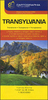
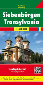
£9.99
In this title, the reverse of the jacket has been printed to be used as a wall poster. In this delightful series of books, under GMC`s exciting new imprint, Button Books, Alain Gree`s stunning vintage illustrations leap out from every page. With three titles, ” Alphabet”, ” Transport” & ” Nature”, aimed at 2-4 years, children will love to be taught their first words with the aid of such absorbing & vibrant illustrations. Despite their simplicity there is a richness of content that children will be fascinated by, & this wealth of information will be a joy for adults to share & discuss, making the potential for learning endless. As an educational tool & a pleasure to own, this fabulous series of books is a wonderful investment for families. ...
Archived Product
£7.99
This gorgeous transport-themed activity book will be very popular with any child who loves all things that go! With over 100 different activities, including dot to dot, spot the difference, colouring in, simple makes & other engaging puzzles. The book is educational as well as fun & features beautiful, bright illustrations that will draw children in & keep them busy. All of the pages are incredibly absorbing, with Alain Gree`s unmistakably rich & appealing style of illustration. & while children are enjoying the mazes, matching & counting, the games are helping them to develop a wide range of skills, including observational, conversational & motor. ...
Archived Product
£6.99
Transport is one of three new additions to this popular non-fiction series. There are four books on the theme of transport
- all
...
Archived Product
£6.99
Transport is one of three new additions to this popular non-fiction series. There are four books on the theme of transport
- all
...
Archived Product
£7.50
Transylvania on an indexed road map at 1:500, 000 from the Hungarian publishers Cartographia. The map provides slightly wider coverage than found on other maps of this region, extending south to include the Iron Gate gorges along the Danube & Bucharest. Relief shading with plenty of names of peaks & mountain ranges gives a good representation of the topography. National parks & protected areas are marked. Road network shows many local roads & prominently indicates scenic routes. Railway lines are included. Symbols mark various places of interest & sites worth visiting, including campsites, spas, etc. Towns & villages have both their Romanian & the old, pre-1920 Hungarian names. Latitude & longitude grid is at 30’ intervals. The index is on the reverse, listing both the current & the historical versions. Map legend

Includes::
English.

...
Archived Product
£30.00
Many people think Transylvania is a fictitious l&, like Ruritania or Narnia. It is the birthplace of Dracula. It is the place where dragons live in Harry Potter & the country to which the Pied Piper spirited the children of Hamelin. Indeed, although Transylvania is a real place, truth here is often stranger than fiction. Streams run with silver, the mountains are full of gold, dinosaur nests are found in river beds & haystacks in trees. It is a country of striking cultural contrasts: of Orthodox monasteries, Gothic churches & Communist follies. While the ` King of the Gypsies` lives in a grandiose modern palace, the future King of England has bought a modest peasant`s house in a remote village. Transylvania only recently awakened from the deep sleep of Communism &, though life is now changing fast, traditions remain here that elsewhere died out long ago. Transylvania captures this vanishing world in words & pictures. ...
Archived Product
£16.99
This new, third edition of Bradt`s Romania: Transylvania remains the only standalone English language guide to this legendary & enchanting region. Comprehensive chapter-per-county coverage is offered, including details to cater for the diverse range of travellers to the region, from city breaks to rural escapes, ski enthusiasts to charity volunteers. Thoroughly updated, this new edition reflects all the changes of the past few years, from enhanced transport infrastructure (in particular the regional airports at Cluj, Sibiu & Targu Mures) to the completion of new motorway routes, such as that between Sibiu & Deva. Also covered are a number of striking new accommodation options: for example the sustainable guesthouse in Valea Zalanului owned by HRH The Prince of Wales, & the mountaintop retreat of Raven`s Nest in the Apuseni Mountains. More attractions have opened up, such as Baroque palaces formerly owned by Hungarian aristocrats, seized under the Communist regime & now being restored by the descendants of their original owners. & the region is developing its offer for new types of tourism, such as summer rock festivals, notably the Untold Festival at Cluj & Electric Castle Festival at Bontida. Transylvania, literally the `land beyond the forest`, is a wild, wooded, intensely romantic region, filled with mountains, gorges & valleys, myths & legends, dragons, bears, wolves
- & vampires. Bram Stoker called it `one of the wildest & least-known parts of Europe` a description which remains true today. One of the most beautiful regions in central Europe & home to three UNESCO World Heritage Sites, Transylvania preserves its cultural & artistic treasures in a unique landscape, bordered on three sides by the Carpathian Mountains. The hay meadows of the lower Carpathians form a man-made, high nature-value grassland ecosystem of extraordinary diversity, offering a beautiful display of wild flowers. The Carpathians are home too to lynx, wild boar, & one of Europe`s largest populations of brown bear. Other natural phenomena include the Scarisoara ice cave in the Apuseni Mountains & the Sfanta Ana volcanic crater lake in Harghita. Whatever your interests, with Bradt`s Romania: Transylvania, you can discover all of the region`s many & varied attractions.
...
Archived Product
£15.99
Transylvania in the Travel Guide series from Bradt; encompassing a comprehensive range of titles to destinations worldwide, with a particular focus on Africa, Central & South America. Bradt are one of the country’s leading independent publishers & have an ethos that focuses on responsible travel, in alliance with a philosophy of sustainability; both in the destinations the guides cover but also in encouraging tourists to limit the impact they have on the local environment. Bradt guides have a reputation for appealing to more independent travelers & often cover destinations that are not available from other publishers. Each guide opens with two comprehensive chapters on Background & Practical Information, covering details of the country’s geography, culture, natural history, government & politics, economy, people, language, religion, education & culture. Important practical advice

Includes::
when to visit, highlights, suggested itineraries, tour operators, red tape, embassies & consulates, getting there & away, health, safety, what to take, money, budgeting, getting around, accommodation, eating & drinking, public holidays, shopping, arts & entertainment, media & communications, business, travel culture & cultural etiquette. Individual sections are organized geographically by region & typically open with information on practicalities & orientation, before focusing on what to see & where to go. Information on what to see, where to stay, where to eat & how to find your way around is provided, with a range of budgets catered for. Simple black & white maps locate key visitor sites & places of accommodation. Bradt Travel Guides include appendices that provide an in-depth introduction to the language of each country, a glossary of terms & a listing of books & internet resources providing further information on the destination.

...
Archived Product
£10.99
Transylvania at 1:400, 000 on a large road map from Freytag & Berndt, with a separate booklet providing extensive index, including historical place names, plus street plans of city centres in the region’s five main towns, Arad, Brasov, Cluj-Napoca, Oradea, Sibiu & Timisoara. All towns & villages are shown with their old historical Hungarian names, with many also given their old German versions. South-western part of the region around the Iron Gate gorges of the Danube is shown as an inset. Subtle relief shading, with names of peaks & mountain ranges presents the topography. Road network shows many local roads, with scenic routes highlighted. Symbols indicate various places of interest, including campsites. Latitude & longitude grid is at 30’ intervals. Map legend

Includes::
English. A booklet attached to the cover

Includes::
small street plans, highlighting various places of interest in the centres of Arad, Brasov, Cluj-Napoca, Oradea, Sibiu, & Timisoara, plus an index of place names, listing both the current & the historical versions.


...
Archived Product
£9.99
Easy to use thanks to its patented folding, the tourist map of Transylvania, central region of Romania, offers all tourist information with a precise topography. Ideal for independent travelers to discover the many castles & the famous fortified churches. ...
Archived Product

Transylvania

Transylvania at 1:400, 000 on a detailed indexed road map from Dimap, with small plans of 11 main towns in the region. All towns and villages are shown with their old historical Hungarian names, and with German names for main towns. South-western part of the region around the Iron Gate gorges of the Danube is shown as an inset.Subtle relief shading, with names of peaks and mountain ranges presents the topography. Road network clearly shows local roads and dirt tracts. Numerous landmarks and places of interest are highlighted, including monuments relating to the region's pre-1914 history, centres of local folk art, World Heritage sites, etc. As befits an area once know for its diversity, five different kinds of local churches are distinguished, and wooden churches are
marked.Latitude and longitude grid is at 10
RIP - This product is no longer available on our network. It was last seen on 25.09.2019

This page now acts as a permanent archive for this product. Add more information using the comments box below to ensure it can still be found by future generations.

Use our search facility to see if it is available from an alternative contributor.
  • External links may include paid for promotion
  • Availability: Out Of Stock
  • Supplier: Stanfords
  • SKU: 9789639251823
Availability: In Stock
£11.95

Product Description

Transylvania at 1:400, 000 on a detailed indexed road map from Dimap, with small plans of 11 main towns in the region. All towns & villages are shown with their old historical Hungarian names, & with German names for main towns. South-western part of the region around the Iron Gate gorges of the Danube is shown as an inset. Subtle relief shading, with names of peaks & mountain ranges presents the topography. Road network clearly shows local roads & dirt tracts. Numerous landmarks & places of interest are highlighted, including monuments relating to the region's pre-1914 history, centres of local folk art, World Heritage sites, etc. As befits an area once know for its diversity, five different kinds of local churches are distinguished, & wooden churches are marked. Latitude & longitude grid is at 10

Reviews/Comments

Add New

Price History

Vouchers

No voucher codes found.
Do you know a voucher code for this product or supplier? Add it to Insights for others to use.

Facebook

Jargon Buster

Wooden - Something that is made from wood, from trees
iron - An electrical deviced used for removing creases from fabrics
iron - A chemical element (FE). The most common element on earth
History - Anything that happens in the past. An acedemic subject.
World - A physical grouping, commonly used to describe earth and everything associated with ti
Network - A link and communication between things. Often computers or people.
Small - something that takes up less space than normal.
Road - a manmade lane or a path that is used to speed up travel.
Subtle - Something that is delicate and not to harsh, can be difficult to describe.

Supplier Information

Stanfords
Stanfords was established in 1853 and opened their iconic Covent Garden flagship store in 1901. They have become the top retailer of maps, travel books and accessories in the UK and arguably offer the largest selection of maps and travel books worldwide. Famous names such as Captain Robert Falcon Scott, Ranulph Fiennes and Michael Palin have purchased from Stanfords. They now have a shop in Bristol and both stores together with other venues operate a calendar of events including talks, book signings and exhibitions. As a specialist map retailer, the map selection is comprehensive and includes road maps, street maps and walking maps from worldwide destinations, as well as a selection of world atlases and wall maps. Books include travel guides and travel literature. Stanfords also stock globes, from miniatures made of blue marble to magnificent floor-standing globes. The website features a selection of interesting articles on travel topics.
Page Updated: 2023-11-12 20:15:36

Community Generated Product Tags

Oh No! The productWIKI community hasn't generated any tags for this product yet!
Menu