More From Contributor
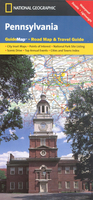
£13.95
The southern section of the Pennine Way between Edale & Horton in Ribblesdale on a waterproof & tear-resistant map at 1:40, 000 from Harvey Map Services presenting the route accompanied by extensive additional tourist information. Divided into six panels, the route is shown on mapping with contours at 15m intervals enhanced by additional graphics for various terrain features such as scattered rocks & boulders, crags, etc. Colouring indicates land cover: pastures, moorl&, woodlands, etc. The overprint highlighting the route shows whether it is on track, path, not visible path or a road, with possible danger points clearly marked. The mapping also highlights other local right of way paths. A wide range of symbols shows various facilities & tourist attractions, including campsites, youth hostels & other accommodation options, food shops & pubs, banks, cycle shops & hire, etc. Each panel has the lines of the British National Grid. Accompanying text provides contact details for tourist information, accommodation bookings, public transport services, etc. To see the full list of Harvey’s maps of long-distance trails please click on the series link. ...
Archived Product
£12.99
The Pennine Way is the 268-mile (431-km) National Trail stretching along the backbone of Britain. This volume features the southern section of the Way, following Natural England's acorn waymarks from Edale in the Peak District across the South Pennine moors & the Yorkshire Dales to Bowes, a distance of 127 miles (204 km). This is the complete, official guide for the long-distance walker or the weekend stroller. National Trail Guides are the official guidebooks to the fifteen National Trails in England & Wales & are published in association with Natural Engl&, the official body charged with developing & maintaining the Trails. ...
Archived Product
£10.95
Waterproof walking map of Pennine Way South at 1:40, 000 from Harvey, with the route divided into individual panels so that you can have the entire trail on one easy-to-read sheet, covering Edale to Horton in Ribblesdale. Cartography shows public bridleways & footpaths, with permissive (permission may be withdrawn) paths indicated. The route is prominently highlighted, with parts on & off road differentiated; dual carriageways, A & B roads, including forest roads, are shown. Railway lines & stops are also marked. Topography is indicated by contour lines at 15m intervals, index contours at 75m intervals, & spot heights; there are numerous symbols to show varying terrain types. The map is GPS compatible, with the National Grid overprinted on each panel. Points of interest & local facilities such as food shops, information points, accommodation, & parking, are clearly marked. The map also has general information on public transport, safety for walkers, accommodation, useful telephone numbers, & more. The map is supplied in a clear plastic pocket. ...
Archived Product
£13.99
Britain`s best-known National Trail winds for 256 miles through three National Parks
- the Peak District, Yorkshire Dales & Northumberl&.
...
Archived Product
£12.99
Originally settled by Swedes, Pennsylvania became the single largest land grant to an individual in history when Charles II of England signed it over to William Penn in 1681. The transaction never turned a profit for Penn, but proved fateful--the colony quickly evolved into a nucleus of American politics, culture, & social reform. This concise volume begins with the history of Pennsylvania from the Native American era to colonial times, when Philadelphia served as the birthplace & first capital of a new nation. It then moves through the centuries to explore the oil, coal, iron, & steel industries that developed in the nineteenth century, ending with an overview of modern-day Pennsylvania, with its varied & complex economy & workforce. * Written in an accessible, popular style * Highlights important trends in politics, society, industry, & culture for each major historical era * 50 b/w photos, illustrations, & maps * Extensive bibliographic list & appendices ...
Archived Product
£30.00
Detailed physical wall map of Pennsylvania & New Jersey States at a scale of 1:500, 000. The cartography shows relief through a stunning, ...
Archived Product
£6.99
Pennsylvania Dutch Country in the Moon Spotlight guide series; covering a range of specific local cities, districts, areas & regions in North, Central & South America & targeted at those seeking to travel to a specific area within a country. Each of the guides has been extracted in full from the relevant country Moon Handbook & individual titles focus on a particular city, region or notable area of the destination. Many of the guides in the series are unique in their coverage, although are limited in putting the destination into its wider geographical context that a more comprehensive guide would provide. Stylistically, Moon ...
Archived Product
£9.99
Pennsylvania on a laminated & waterproof Easy-to-Fold map from Rand Mc Nally, the country’s leading publisher of road maps & street plans. For clarity of road information Rand Mc Nally state maps present the road network on a plain background, with no or little topographic detail. Driving distances are indicated on all principal highways & on many local routes. National or state parks & other protected areas, Indian Reservations & restricted entry military zones are highlighted & symbols indicate campsites, rest areas, various places of interest, etc. Each map shows local administrative boundaries with names of the counties, is indexed & gives geographical coordinates as margin ticks usually at 1° intervals. Rand Mc Nally state maps are available in two formats: double-sided Easy-to-Read maps with numerous enlargements for cities and/or most visited areas, & laminated Easy-to-Fold maps in a more handy format but with smaller print. TO SEE THE LIST OF RAND Mc NALLY STATE MAPS PLEASE CLICK ON THE SERIES LINK. ...
Archived Product
£6.99
Pensylvania Easy-to-Read map from Rand Mc Nally, US leading publisher of road maps & street plans, in their extensive series of state maps. Additional panels provide enlargements for: Allentown
- Bethlehem, Altoona, Erie, Gettysburg, Harrisburg, Johnstown, Lancaster, Philadelphia & vicinity, downtown Philadelphia, Pittsburgh & vicinity, downtown Pittsburgh, Reading, Scranton
- Wilkes-Barre, & York. For clarity of road information Rand Mc Nally state maps present the road network on a plain background, with no or little topographic detail. Driving distances are indicated on all principal highways & on many local routes. National or state parks & other protected areas, Indian Reservations & restricted entry military zones are highlighted & symbols indicate campsites, rest areas, various places of interest, etc. Each map shows local administrative boundaries with names of the counties, is indexed & gives geographical coordinates as margin ticks usually at 1° intervals. Rand Mc Nally state maps are available in two formats: double-sided Easy-to-Read maps with numerous enlargements for cities and/or most visited areas, & laminated Easy-to-Fold maps in a more handy format but with smaller print. TO SEE THE LIST OF RAND Mc NALLY STATE MAPS PLEASE CLICK ON THE SERIES LINK.

...
Archived Product

Pennsylvania

Pennsylvania in a series of US state maps from the National Geographic with cartography from Mapquest, including city maps Philadelphia and Pittsburg, - each with an enlargement of the downtown area, Allentown - Bethlehem, Altoona, Erie, Harrisburg, Johnstown, Lancaster, Reading, Scranton - Wilkes - Barre, State College and York, an enlargement for the Gettysburg National Military Park, plus a scenic drive route across the Amish country from Gap to Marietta. The map is printed on lightweight, waterproof and tear-resistant plastic paper.Maps in the NGS State Series clearly show each state’s national parks, forests and other protected areas, with topography indicated by subtle relief shading and plenty of names of mountain ranges, valleys, deserts, etc. Indian
Reservations are also marked and various places of interest are highlighted, including historical or natural sites, visitor information centres, campsites, etc.Road network indicates toll roads, rest areas and services, and shows driving distances on main routes. Scenic roads are highlighted. The maps have no geographical coordinates. The index lists both counties, shown on the maps with their administrative boundaries, and towns or cities. Each title includes several enlargements showing in greater detail local towns, national parks and other popular destination, all annotated with places of interest. Also provided are general notes about the state with descriptions of its main sights, a recommendation for a scenic drive, a table of services available in the local sites (both
national parks and historical monuments), a calendar of local special events, a distance table and a climate chart.
RIP - This product is no longer available on our network. It was last seen on 25.09.2019

This page now acts as a permanent archive for this product. Add more information using the comments box below to ensure it can still be found by future generations.

Use our search facility to see if it is available from an alternative contributor.
  • External links may include paid for promotion
  • Availability: Out Of Stock
  • Supplier: Stanfords
  • SKU: 9781597750950
Availability: In Stock
£6.99

Product Description

Pennsylvania in a series of US state maps from the National Geographic with cartography from Mapquest, including city maps Philadelphia & Pittsburg,
- each with an enlargement of the downtown area, Allentown
- Bethlehem, Altoona, Erie, Harrisburg, Johnstown, Lancaster, Reading, Scranton
- Wilkes
- Barre, State College & York, an enlargement for the Gettysburg National Military Park, plus a scenic drive route across the Amish country from Gap to Marietta. The map is printed on lightweight, waterproof & tear-resistant plastic paper. Maps in the NGS State Series clearly show each state’s national parks, forests & other protected areas, with topography indicated by subtle relief shading & plenty of names of mountain ranges, valleys, deserts, etc. Indian Reservations are also marked & various places of interest are highlighted, including historical or natural sites, visitor information centres, campsites, etc. Road network indicates toll roads, rest areas & services, & shows driving distances on main routes. Scenic roads are highlighted. The maps have no geographical coordinates. The index lists both counties, shown on the maps with their administrative boundaries, & towns or cities. Each title

Includes::
several enlargements showing in greater detail local towns, national parks & other popular destination, all annotated with places of interest. Also provided are general notes about the state with descriptions of its main sights, a recommendation for a scenic drive, a table of services available in the local sites (both national parks & historical monuments), a calendar of local special events, a distance table & a climate chart.

Reviews/Comments

Add New

Price History

Vouchers

No voucher codes found.
Do you know a voucher code for this product or supplier? Add it to Insights for others to use.

Facebook

Jargon Buster

Paper - A thin sheet mainly used for writing. Available in a variety of colours. Made mainly from wood pulp.
Plastic - A generic term for a synthetic product used in the manufacture of products
Calendar - A system for organising dates
Waterproof - Resistant to water, usualy specified by depth in metres
Natural - not manmade
Network - A link and communication between things. Often computers or people.
Road - a manmade lane or a path that is used to speed up travel.
Resistant - Something that can repel against something.
Popular - Something that is admired and liked by many people.
Subtle - Something that is delicate and not to harsh, can be difficult to describe.

Supplier Information

Stanfords
Stanfords was established in 1853 and opened their iconic Covent Garden flagship store in 1901. They have become the top retailer of maps, travel books and accessories in the UK and arguably offer the largest selection of maps and travel books worldwide. Famous names such as Captain Robert Falcon Scott, Ranulph Fiennes and Michael Palin have purchased from Stanfords. They now have a shop in Bristol and both stores together with other venues operate a calendar of events including talks, book signings and exhibitions. As a specialist map retailer, the map selection is comprehensive and includes road maps, street maps and walking maps from worldwide destinations, as well as a selection of world atlases and wall maps. Books include travel guides and travel literature. Stanfords also stock globes, from miniatures made of blue marble to magnificent floor-standing globes. The website features a selection of interesting articles on travel topics.
Page Updated: 2023-11-12 20:15:36

Community Generated Product Tags

Oh No! The productWIKI community hasn't generated any tags for this product yet!
Menu