
 United Kingdom
 France
 Germany
 Netherlands
 Sweden
 USA
USA
 Italy
Italy
 Spain
Spain
More From Contributor


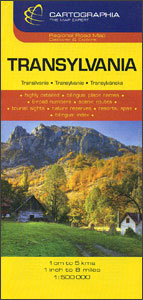
Transylvania
Transylvania on an indexed road map at 1:500, 000 from the Hungarian publishers Cartographia. The map provides slightly wider coverage than found on other maps of this region, extending south to include the Iron Gate gorges along the Danube and Bucharest. Relief shading with plenty of names of peaks and mountain ranges gives a good representation of the topography. National parks and protected areas are marked. Road network shows many local roads and prominently indicates scenic routes. Railway lines are included. Symbols mark various places of interest and sites worth visiting, including campsites, spas, etc.Towns and villages have both their Romanian and the old, pre-1920 Hungarian names. Latitude and longitude grid is at 30’ intervals. The index is on the reverse, listing both
the current and the historical versions. Map legend includes English.
the current and the historical versions. Map legend includes English.

Product Description
Reviews/Comments
Add New
Intelligent Comparison
Archived Product
Transylvania Stanfords
£11.95
Archived Product

Transylvania Stanfords
£30.00
Archived Product
Transylvania Stanfords
£16.99
Archived Product
Transylvania F&B Stanfords
£10.99
Archived Product

Pennsylvania Stanfords
£6.99
Archived Product

TransAtlantic Stanfords
£8.99
Vouchers
No voucher codes found.
Do you know a voucher code for this product or supplier? Add it to Insights for others to use.
Do you know a voucher code for this product or supplier? Add it to Insights for others to use.
 Denmark