
 United Kingdom
 France
 Germany
 Netherlands
 Sweden
 USA
USA
 Italy
Italy
 Spain
Spain
More From Contributor


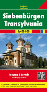
Transylvania F&B
Transylvania at 1:400, 000 on a large road map from Freytag & Berndt, with a separate booklet providing extensive index, including historical place names, plus street plans of city centres in the region’s five main towns, Arad, Brasov, Cluj-Napoca, Oradea, Sibiu and Timisoara.All towns and villages are shown with their old historical Hungarian names, with many also given their old German versions. South-western part of the region around the Iron Gate gorges of the Danube is shown as an inset. Subtle relief shading, with names of peaks and mountain ranges presents the topography. Road network shows many local roads, with scenic routes highlighted. Symbols indicate various places of interest, including campsites. Latitude and longitude grid is at 30’ intervals. Map legend
includes English. A booklet attached to the cover includes small street plans, highlighting various places of interest in the centres of Arad, Brasov, Cluj-Napoca, Oradea, Sibiu, and Timisoara, plus an index of place names, listing both the current and the historical versions.
includes English. A booklet attached to the cover includes small street plans, highlighting various places of interest in the centres of Arad, Brasov, Cluj-Napoca, Oradea, Sibiu, and Timisoara, plus an index of place names, listing both the current and the historical versions.

Product Description
Reviews/Comments
Add New
Vouchers
No voucher codes found.
Do you know a voucher code for this product or supplier? Add it to Insights for others to use.
Do you know a voucher code for this product or supplier? Add it to Insights for others to use.
 Denmark