
 United Kingdom
 France
 Germany
 Netherlands
 Sweden
 USA
USA
 Italy
Italy
 Spain
Spain
More From Contributor


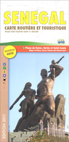
Senegal
Senegal road map at 1:1, 000, 000 from Laure Kane, specialist in maps of north-African destinations, with street plans of Dakar, Gorée Island and Saint-Louis, plus an administrative map of the country and a distance table.The map shows the country’s network of trunk, regional and secondary roads, plus a selection of other local roads or passable tracks. Locations of petrol stations and border crossings are marked. Railway lines are shown with stations and local airfields are indicated. A range of symbols indicate various places of interest, including beaches, historical sites, medical centres, etc. Topography is indicated by altitude colouring, with graphics to indicate flood zones and colouring for national parks. Also marked are the country’s internal administrative
boundaries with town symbols showing their administrative status. The map is not indexed and has no geographical coordinates.Separate insets show streets plan of Dakar and the Gorée Island, plus a more general plan of Saint-Louis, all annotated with places of interest. Also provided is a small administrative map of the country and a distance table.
boundaries with town symbols showing their administrative status. The map is not indexed and has no geographical coordinates.Separate insets show streets plan of Dakar and the Gorée Island, plus a more general plan of Saint-Louis, all annotated with places of interest. Also provided is a small administrative map of the country and a distance table.

Product Description
Reviews/Comments
Add New
Vouchers
No voucher codes found.
Do you know a voucher code for this product or supplier? Add it to Insights for others to use.
Do you know a voucher code for this product or supplier? Add it to Insights for others to use.
 Denmark