
 United Kingdom
 France
 Germany
 Netherlands
 Sweden
 USA
USA
 Italy
Italy
 Spain
Spain
More From Contributor


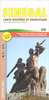


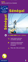
Senegal
Senegal road map at 1:1, 000, 000 from the IGN, France’s national survey organization, with plans of Dakar and Saint-Louis, plus an enlargement for the Cap Vert peninsula. The map has relief shading and indicates areas of different types of vegetation. Railways and various sizes of airfields and aerodromes shown, and the road network indicates seasonal routes. Boundaries of national parks and forest reserves are marked, but the map has no other specific tourist information. Latitude and longitude are shown in the margins at 1º intervals, with cross ticks on the map itself. The map also includes an enlargement for the Cap Vert peninsula and insets showing Dakar and Saint-Louis, naming main streets. Map legend is in French only. Information within Gambia is limited to main
settlements and connecting roads.
settlements and connecting roads.

Product Description
Reviews/Comments
Add New
Vouchers
No voucher codes found.
Do you know a voucher code for this product or supplier? Add it to Insights for others to use.
Do you know a voucher code for this product or supplier? Add it to Insights for others to use.
 Denmark