More From Contributor
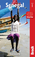
£10.99
Senegal road map at 1:1, 000, 000 from the IGN, France’s national survey organization, with plans of Dakar & Saint-Louis, plus an enlargement for the Cap Vert peninsula. The map has relief shading & indicates areas of different types of vegetation. Railways & various sizes of airfields & aerodromes shown, & the road network indicates seasonal routes. Boundaries of national parks & forest reserves are marked, but the map has no other specific tourist information. Latitude & longitude are shown in the margins at 1º intervals, with cross ticks on the map itself. The map also

Includes::
an enlargement for the Cap Vert peninsula & insets showing Dakar & Saint-Louis, naming main streets. Map legend is in French only. Information within Gambia is limited to main settlements & connecting roads.

...
Archived Product
£9.99
Senegal road map at 1:1, 000, 000 from Laure Kane, specialist in maps of north-African destinations, with street plans of Dakar, Gorée Island & Saint-Louis, plus an administrative map of the country & a distance table. The map shows the country’s network of trunk, regional & secondary roads, plus a selection of other local roads or passable tracks. Locations of petrol stations & border crossings are marked. Railway lines are shown with stations & local airfields are indicated. A range of symbols indicate various places of interest, including beaches, historical sites, medical centres, etc. Topography is indicated by altitude colouring, with graphics to indicate flood zones & colouring for national parks. Also marked are the country’s internal administrative boundaries with town symbols showing their administrative status. The map is not indexed & has no geographical coordinates. Separate insets show streets plan of Dakar & the Gorée Isl&, plus a more general plan of Saint-Louis, all annotated with places of interest. Also provided is a small administrative map of the country & a distance table. ...
Archived Product
£9.99
Senegal with Gambia at 1:740, 000 with, on the reverse, Gambia itself at a more detailed scale of 1;340, 000 on an indexed road map from ITMB with street plans of Dakar, Ile de Gorée & Banjul. Brief annotations accompany various places of interest highlighted in the map. On one side is Senegal with Gambia at 1:740, 000, with on the reverse Gambia shown in greater detail at 1:340, 000, with many more settlements & roads or tracks. Topography on both maps is shown by altitude colouring (in metres), with graphics for mangrove/swamps & salt pans. Within Senegal numeroud national parks & other protected areas are highlighted. Road network distinguishes between all season & seasonal roads &

Includes::
selected tracks. Driving distances are marked on main routes, & the map also indicates locations of petrol supplies & border crossings. Railway lines are included & local airports are marked. The maps also show each country’s internal administrative boundaries with names of the provinces. Various places of interest are highlighted, many annotated with brief descriptions. The map also indicates locations with tourist accommodation and/or medical facilities. Latitude & longitude lines are drawn at 1° intervals (Senegal/ Gambia) & 15’ (Gambia). Each country has a separate index. The map

Includes::
street plans of Dakar, Ile de Gorée & Banjul, showing main streets & indicating locations of various places of interest, including selected hotels. Also provided is a small inset showing precipitation/aridity in that part of Western Africa.


...
Archived Product
£11.50
Senegal & Gambia at 1:550, 000 on an indexed, waterproof & tear-resistant road map of with topographic & tourist information, published by Reise Know-How as part of their highly acclaimed World Mapping Project. The map is double-sided, with a good overlap, to provide the best balance between a good scale & a convenient size sheet. Topography is shown by altitude colouring with contours, spot heights, marshes & flooding zones, seasonal rivers, mangroves, deserts & quicksand areas, wells, oases, etc. Numerous national parks & protected areas are highlighted. Road network

Includes::
local dirt tracks, indicating driving distances on main roads. Railway lines & local airfields are also marked. Internal administrative boundaries are shown with names of the provinces. Symbols highlight various places of interest, including UNESCO heritage sites, archaeological remains, churches & mosques, selected hotels & campsites, etc. The map has a latitude & longitude grid at intervals of 30’ & an extensive index of place names. Map legend

Includes::
English.


...
Archived Product
£9.50
Indexed, waterproof & tear-resistant road map of Senegal & Gambia with topographic & tourist information, published by Reise Know-How as part of their highly acclaimed World Mapping Project. The map is double-sided to provide the best balance between a good scale & a convenient size sheet. Topography is shown by altitude colouring with contours, spot heights, marshes & flooding zones, seasonal rivers, mangroves, deserts & quicksand areas, wells, oases, etc. Numerous national parks & protected areas are highlighted. Road network

Includes::
local dirt tracks, indicating driving distances on main roads. Railway lines & local airfields are also marked. Internal administrative boundaries are shown with names of the provinces. A wide range of symbols highlights various places of interest, including UNESCO heritage sites, archaeological remains, churches & mosques, selected hotels & campsites, etc. The map has a latitude & longitude grid at intervals of 30

...
Archived Product
£22.99
The Senja National Tourist Route Map belongs to a series of 18 map & postcards sets describing popular tourist routes all over Norway. The map set

Includes::
a map in 1: 50, 000 presenting an accurate topography (based on the Norwegian topographic survey) which describes local footpaths, cycle or ski routes, sport & recreational facilities, places of interest, places to stay & eat, viewpoints. Senja National Tourist Route is a 90-kilometre-long stretch of road between Gryllefjord & Botnhamn on the island Senja in the county of Troms in Northern Norway. In addition, the official route

Includes::
detours to Mefjordvær & Husøya, for an additional 12 kilometres of road. The rich fishing in the sea has shaped life on the isl&. In the fjords there are characteristic examples of the lively coastal culture. Small, scattered fishing hamlets & villages claw onto thin strips of land between the mountains & the sea. Here you will find the beautiful Husøya with a population of less than 250 & a five-minute walk to anywhere. An exotic gem with traditions from former Spanish shipwrecks
- the siesta is alive & well on Senja. Senja is hospitable all year round, in summer with its constant light, but also in winter with its short days & changeable weather. There are two panoramic view & rest areas: Tungeneset, rest area with services & full accessibility close to the sea. Here, scenic rock cauldrons are refilled by the sea every day at high tide & quickly heated by the sun. & Bergsbotn, a rest area & viewing platform with a magnificent view over the Bergsfjord & the sea beyond. The set
Features: One map: scale 1:50, 000 Text in three languages (Norwegian, English & German)5 Postcards (13.5x 25cm) To see the list of other titles in this series, please click on the series link.


...
Archived Product
£23.99
Map No. 10151, Senjahopen, in the new topographic survey of Norway at 1:50, 000 covering the country on 195 double-sided sheets & first published by Nordeca in 2011
- 2012; fully GPS compatible, indicating waymarked footpaths, campsites, tourist huts, illuminated ski runs, etc. The maps, now published by Nordeca, the successors to Statens Kartverk & its subsequent owners the Ugland Group, are printed on light, waterproof & tear-resistant synthetic paper. Each map covers an area of 62x 45 kilometres (39 x 28 miles approx.), with a 2-km overlap between the sheets. The maps have contours at 20m intervals (10m glacier contours), plus colouring & graphics to show cultivated areas, bogs, forests, etc. In addition to all the information expected of topographic mapping at this scale the maps distinguish between waymarked & unmarked footpaths & show campsites, tourist huts (serviced/self service/no supplies), country hotels & restaurants, & illuminated ski trails. The series uses EUREF89 (WGS84) datum & the maps have a 1-km UTM grid. Map legend is in Norwegian & English. Each title comes in a sturdy protective card envelope.
...
Archived Product
£7.99
Howard Marks was released from Terre Haute Penitentiary, Indiana in April 1995 after serving seven years of a twenty-five year sentence for marijuana smuggling. It was time for a change of career. So he wrote two best-selling books, became a sports writer & travel writer, stood as a parliamentary candidate in Norwich North, Norwich South, Southampton Test & Neath, applied to become the country`s Drug Czar, & embarked on a long-running sell-out series of one man shows. While performing in his home town of Kenfig Hill, he fell among old friends who made extraordinary claims for Welsh culture (Was Elvis really Welsh? Was there really a tribe of Welsh-speaking Native Americans?) At the same time his elderly aunt told him of his outlaw ancestry: William Owen, the legendary Welsh smuggler (who had operated for some time in South America) & his great-great-grandfather Patrick Mc Carty, the half brother of Billy the Kid, who had joined Butch Cassidy & the Sundance Kid in Patagonia. He decided to explore South America. His travels took him to Jamaica & Panama in the footsteps of the Welsh buccaneer Henry Morgan; he went to Brazil looking for groups of Welsh settlers so obscure he never found them (although he did succeed in finding his musical idol Jimmy Page); & he searched among the thriving Welsh community in Patagonia for signs of Billy the Kid`s half brother. Richly comic & charged with the sense of adventure that would induce an Oxford graduate to become the world`s most notorious marijuana smuggler, ” Senor Nice” is the hugely entertaining sequel to ” Mr Nice”. ...
Archived Product
£8.99
Dionisio Vivo, a South American lecturer in philosophy, is puzzled by the hideously mutilated corpses that keep turning up outside his front door. To his friend, Ramon, one of the few honest policemen in town, the message is all too clear: Dionisio`s letters to the press, exposing the drug barons, must stop; & although Dionisio manages to escape the hit-men sent to get him, he soon realises that others are more vulnerable, & his love for them leads him to take a colossal revenge. ...
Archived Product
£12.99
Topographic survey of France at 1:25, 000 in IGN`s excellent TOP25 / Série Bleue series. All the maps are GPS compatible, with a 1km UTM grid plus latitude & longitude lines at 5’ intervals. Contours are at 5m intervals except for mountainous areas where the maps have contours at 10m intervals, vividly enhanced by hill shading & graphics for rocky terrain. Colouring with graphics indicates different types of vegetation or land use (deciduous or coniferous forests, moors, orchards, vineyards, etc). PLEASE NOTE: coverage of France at this scale is currently being revised – the format & the presentation of each title are indicated by the letters at the end of its Sheet Reference number (e.g. 0416ET, 3531ETR, 1923SB, etc.)MAPS WITH FULL TOURIST OVERPRINT & AN ENGLISH MAP LEGEND: all TOP25 maps & the SB editions of Série Bleue have an overprint highlighting waymarked walking trails including long-distance GR routes &, where appropriate, ski routes. Symbols indicate campsites, gîtes d’etape, refuges, equestrian centres & other recreational facilities or sites, tourist information centres, cultural heritage, etc. Towns & locations of particular interest are highlighted.- ET or OT = single-sided TOP25 map covering approx. 29x 21 km / 18x 13 miles.- ETR or OTR = waterproof & tear resistant TOP25 map covering the same area as the corresponding ET or OT number, but double-sided, printed on a smaller size sheet with a good overlap between the sides.- SB = Série Bleue map with full tourist overprint; these maps, first introduced in summer 2014, each cover approx. 29x 24km / 18x 15 miles.SÉRIE BLEUE maps with numbers ending in E (Est) or O (Ouest): most editions now indicate the GR routes, but do not show any other tourist information. Map legend is in French only. Each map covers approx. 14x 20km / 9x 12 miles. ...
Archived Product

Senegal Bradt Guide

Like the whole of West Africa in microcosm, Senegal boasts a variety of landscapes and cultures that belie its compact size. Northern desert wilds give way to the rain-soaked Casamance, fringed by hundreds of kilometres of pristine beaches and the fantastically frenetic capital city, Dakar, surrounded by ocean and proudly perched at the westernmost point on the African continent. This smorgasbord of landscapes is all accessible within a day`s travel, making Senegal the perfect choice for anyone looking to sink their teeth into West Africa, for the first time or the hundredth.
RIP - This product is no longer available on our network. It was last seen on 25.09.2019

This page now acts as a permanent archive for this product. Add more information using the comments box below to ensure it can still be found by future generations.

Use our search facility to see if it is available from an alternative contributor.
  • External links may include paid for promotion
  • Availability: Out Of Stock
  • Supplier: Stanfords
  • SKU: 9781841629131
Availability: In Stock
£17.99

Product Description

Like the whole of West Africa in microcosm, Senegal boasts a variety of landscapes & cultures that belie its compact size. Northern desert wilds give way to the rain-soaked Casamance, fringed by hundreds of kilometres of pristine beaches & the fantastically frenetic capital city, Dakar, surrounded by ocean & proudly perched at the westernmost point on the African continent. This smorgasbord of landscapes is all accessible within a day`s travel, making Senegal the perfect choice for anyone looking to sink their teeth into West Africa, for the first time or the hundredth.

Reviews/Comments

Add New

Intelligent Comparison

Oooops!
We couldn't find anything!
Perhaps this product's unique.... Or perhaps we are still looking for comparisons!
Click to bump this page and we'll hurry up.

Price History

Vouchers

No voucher codes found.
Do you know a voucher code for this product or supplier? Add it to Insights for others to use.

Facebook

Jargon Buster

compact - Carefuly designed to ensure an item has a minimal physical size
Day - The time it takes a planet or other space objects to complete one rotation.
Size - is the measurement of how big an object is in space.
Compact - something that has a lot combined within a small space.

Supplier Information

Stanfords
Stanfords was established in 1853 and opened their iconic Covent Garden flagship store in 1901. They have become the top retailer of maps, travel books and accessories in the UK and arguably offer the largest selection of maps and travel books worldwide. Famous names such as Captain Robert Falcon Scott, Ranulph Fiennes and Michael Palin have purchased from Stanfords. They now have a shop in Bristol and both stores together with other venues operate a calendar of events including talks, book signings and exhibitions. As a specialist map retailer, the map selection is comprehensive and includes road maps, street maps and walking maps from worldwide destinations, as well as a selection of world atlases and wall maps. Books include travel guides and travel literature. Stanfords also stock globes, from miniatures made of blue marble to magnificent floor-standing globes. The website features a selection of interesting articles on travel topics.
Page Updated: 2023-11-12 20:15:36

Community Generated Product Tags

Oh No! The productWIKI community hasn't generated any tags for this product yet!
Menu