
 United Kingdom
 France
 Germany
 Netherlands
 Sweden
 USA
USA
 Italy
Italy
 Spain
Spain
More From Contributor


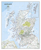

Scotland NGS Executive Wall Map ENCAPSULATED
A wall map of Scotland, 76 x 91cm (2ft 6” x 3ft approx) – encapsulated version, from the National Geographic Society in their executive style designed to present current information in colouring reminiscent of antique maps with shades of beige and brown.The map presents Scotland on a base with relief shading to show the country’s topography, with plenty of names of geographical features: mountain ranges, peaks, lochs and sounds of the coastal waters, etc. National Parks are highlighted.The map shows the division of Scotland into council areas. In addition to the road and rail networks, airports with scheduled services and ferry routes are marked. Also shown are oil pipelines and various historical sites.* This map is also available on paper without the encapsulation.*LAMINATED
and ENCAPSULATED WALL MAPS:*- *laminated* wall maps have a thin layer of plastic usually applied to the printed side only. They can be written on with suitable marker pens without any damage to the map but, unless laminated on both sides, they are not damp-proof.- *encapsulated* wall maps are sealed between two sheets of plastic. They are more rigid and heavier than laminated maps of the same size. They are damp-proof and do not crinkle in humid conditions. Encapsulation gives the map a shiny surface, similar to being displayed behind glass.- *please note:* many publishers and retailers often use these two terms interchangeably. Our map titles and descriptions follow the definitions provided above.
and ENCAPSULATED WALL MAPS:*- *laminated* wall maps have a thin layer of plastic usually applied to the printed side only. They can be written on with suitable marker pens without any damage to the map but, unless laminated on both sides, they are not damp-proof.- *encapsulated* wall maps are sealed between two sheets of plastic. They are more rigid and heavier than laminated maps of the same size. They are damp-proof and do not crinkle in humid conditions. Encapsulation gives the map a shiny surface, similar to being displayed behind glass.- *please note:* many publishers and retailers often use these two terms interchangeably. Our map titles and descriptions follow the definitions provided above.
Product Description
Reviews/Comments
Add New
Vouchers
No voucher codes found.
Do you know a voucher code for this product or supplier? Add it to Insights for others to use.
Do you know a voucher code for this product or supplier? Add it to Insights for others to use.
 Denmark