More From Contributor

£12.99
Scotland at 1:400, 000 on an indexed touring map from Michelin
- laminated version
- particularly good for indentifying scenic

...
Archived Product
£4.99
Scotland in the AA Mini Guide series; comprising a selection of handy, pocket sized guides to a range of British regions &


...
Archived Product
£15.95
Vertebrate’s guide to mountain biking in Scotland covers 25 recommended mountain bike trails, routes & rides ranging from 6km to 290km. The routes themselves have been devised & tested by local riders to help you get the very best out of the North & South Downs trails. Each route is described with easy-to-follow instructions, information on difficulty, length, nearest refreshments (usually a recommended pub), altitude profile, & parking. The maps is taken from Ordnance Survey Landranger (1:50, 000) mapping with the cycle routes prominently highlighted. There are optional routes given as well for each ride, & the guide contains tips on safety, bike-riding day or night, & has a special section

Includes::
details of the Coast-to-Coast tour from Fort William to Montrose.

...
Archived Product
£15.95
” Scotland Mountain Biking
- Wild Trails Vol.2” features 24 classic mountain bike rides across Scotl&. Like the original Wild
...
Archived Product
£25.00
Cicerone’s Scotland Mountain Range Guide is full of route & practical information for the independent mountain lover, whether with a view to walking, climbing, scrambling or ski touring in terrain such as the Southern Uplands, the great granite plateaus of the Cairngorms & the jagged arêtes of the Cuillin hills on the Isle of Skye. Descriptions are provided on all Scottish mountains, arranged area-by-area from south to north, including classic ascents up Ben Nevis. Comprehensive information is provided on routes, aswell as access & bases. Appendices contain a glossary of mountain words in Gaelic & Scots, as well as a bibliography of further reading & a comprehensive list of Munros. A legend system is also used in the text; with symbols representing low-level/passes walks, long distance walks, summit walks, scrambles, rock climbs, winter climbs, ski tours, other local points of interest, chapter highlight. Map pages, designed for pre-trip overview planning rather than use in the field, include road & topographic detail, as well as long distance footpaths & 50m contour lines. Steep gradients & spot heights are marked, as well as accommodation & visitor sights. ...
Archived Product
£16.99
A wall map of Scotl&, 76 x 91cm (2ft 6” x 3ft approx) – encapsulated version, from the National Geographic Society in their traditional “classic” style: a pale beige base with relief shading, road & rail networks, county boundaries, etc. The map presents Scotland on a base with relief shading to show the country’s topography, with plenty of names of geographical

Features:
mountain ranges, peaks, lochs & sounds of the coastal waters, etc. National Parks are highlighted. The map shows the division of Scotland into council areas. In addition to the road & rail networks, airports with scheduled services & ferry routes are marked. Also shown are oil pipelines & various historical sites.* This map is also available on paper without the encapsulation.*LAMINATED & ENCAPSULATED WALL MAPS:*- *laminated* wall maps have a thin layer of plastic usually applied to the printed side only. They can be written on with suitable marker pens without any damage to the map but, unless laminated on both sides, they are not damp-proof.- *encapsulated* wall maps are sealed between two sheets of plastic. They are more rigid & heavier than laminated maps of the same size. They are damp-proof & do not crinkle in humid conditions. Encapsulation gives the map a shiny surface, similar to being displayed behind glass.- *please note:* many publishers & retailers often use these two terms interchangeably. Our map titles & descriptions follow the definitions provided above.

...
Archived Product
£12.99
A wall map of Scotl&, 76 x 91cm (2ft 6” x 3ft approx) – paper version, from the National Geographic Society in their traditional “classic” style: a pale beige base with relief shading, road & rail networks, county boundaries, etc. The map presents Scotland on a base with relief shading to show the country’s topography, with plenty of names of geographical

Features:
mountain ranges, peaks, lochs & sounds of the coastal waters, etc. National Parks are highlighted. The map shows the division of Scotland into council areas. In addition to the road & rail networks, airports with scheduled services & ferry routes are marked. Also shown are oil pipelines & various historical sites.* This map is also available encapsulated.

...
Archived Product
£16.99
A wall map of Scotl&, 76 x 91cm (2ft 6” x 3ft approx) – encapsulated version, from the National Geographic Society in their executive style designed to present current information in colouring reminiscent of antique maps with shades of beige & brown. The map presents Scotland on a base with relief shading to show the country’s topography, with plenty of names of geographical

Features:
mountain ranges, peaks, lochs & sounds of the coastal waters, etc. National Parks are highlighted. The map shows the division of Scotland into council areas. In addition to the road & rail networks, airports with scheduled services & ferry routes are marked. Also shown are oil pipelines & various historical sites.* This map is also available on paper without the encapsulation.*LAMINATED & ENCAPSULATED WALL MAPS:*- *laminated* wall maps have a thin layer of plastic usually applied to the printed side only. They can be written on with suitable marker pens without any damage to the map but, unless laminated on both sides, they are not damp-proof.- *encapsulated* wall maps are sealed between two sheets of plastic. They are more rigid & heavier than laminated maps of the same size. They are damp-proof & do not crinkle in humid conditions. Encapsulation gives the map a shiny surface, similar to being displayed behind glass.- *please note:* many publishers & retailers often use these two terms interchangeably. Our map titles & descriptions follow the definitions provided above.

...
Archived Product
£5.95
Scotland at 1:316, 800 (5 miles to 1 inch) on a double-sided road map from A-Z. Coverage extends south to Blackpool & York, to include the Lake District & Yorkshire Dales, but the map has no overlap between the sides. The index is in a separate booklet attached to the map cover. Current edition of this title was published in 2015. Maps in this “ Five miles to 1 inch” series from A-Z show areas above 400 feet (122 metres) & woodlands by colouring & relief shading; spot heights are in feet. The colouring of the road network clearly distinguishes between primary routes & other A roads, with B roads also easy to follow on all backgrounds. The maps are primarily designed for route planning, so smaller country roads are perhaps less clear to see, with the publishers recommending their alternative series for more detailed local coverage (please search for SI00000215 or SI00000882). Railway lines are included & shown with stations, but at times difficult to find. A wide range of symbols highlight numerous places of interest. Each map has British National Grid lines & is indexed. IMPORTANT
- PLEASE NOTE: many place names & all additional tourist information is in very small lettering, requiring good eyesight or a magnifying glass. To see the list of titles in this series please click on the series link.
...
Archived Product
£6.99
Double-sided Wall map of North & South Scotland at 1:316, 800 (5 miles to 1 inch) from Geographers` A-Z Map Company for traditionalists who prefer their maps drawn at scales corresponding to the imperial measurements of miles to inches, with colourful presentation of topography & hill heights in feet. Presentation of the topography varies slightly, from bold altitude colouring in older editions to slightly gentler colours enhanced by relief shading on more recent maps, both very effectively showing the more hilly or mountainous parts of the country. All maps have spot heights shown in feet. The colouring of the road network clearly distinguishes between primary routes & other A roads for route planning, with B roads also easy to follow on all backgrounds. Smaller country roads are less clear to see, with the publishers recommending their alternative series for more detailed local coverage. Railway lines are included & shown with stations, but at times difficult to find. British national grid lines are overprinted on the cartography & a separate booklet is supplied containing the index to cities, towns, villages, hamlets & locations.* *IMPORTANT
- PLEASE NOTE: many place names & all additional tourist information is in very small lettering, requiring good eyesight or a magnifying glass.*
...
Archived Product

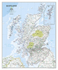
Scotland Munro Bagging Collect And Scratch Print

For those that love the mountains of Scotland you can scratch off the Munros and Munro areas as you bag them. Keep your running total too. Happy Bagging!The Scratch Off Munro-bagging Print is part of the Collect and Scratch range and shows all of the 282 Munro hill tops including their heights, covered by a scratch-off latex. This allows you to document each one you have `Bagged` by scratching off the foil to reveal some colour underneath. Also featured on the map is a tally that you can update with a dry wipe pen as you go along so you can see how many more you need to `Bag`.
RIP - This product is no longer available on our network. It was last seen on 25.09.2019

This page now acts as a permanent archive for this product. Add more information using the comments box below to ensure it can still be found by future generations.

Use our search facility to see if it is available from an alternative contributor.
  • Availability: Out Of Stock
  • Supplier: Stanfords
  • SKU: 9781910378199
Availability: In Stock
£15.99

Product Description

For those that love the mountains of Scotland you can scratch off the Munros & Munro areas as you bag them. Keep your running total too. Happy Bagging! The Scratch Off Munro-bagging Print is part of the Collect & Scratch range & shows all of the 282 Munro hill tops including their heights, covered by a scratch-off latex. This means that you can document each one you have ` Bagged` by scratching off the foil to reveal some colour underneath. Also featured on the map is a tally that you can update with a dry wipe pen as you go along so you can see how many more you need to ` Bag`.

Reviews/Comments

Add New

Intelligent Comparison

Oooops!
We couldn't find anything!
Perhaps this product's unique.... Or perhaps we are still looking for comparisons!
Click to bump this page and we'll hurry up.

Price History

Vouchers

No voucher codes found.
Do you know a voucher code for this product or supplier? Add it to Insights for others to use.

Facebook

Jargon Buster

Dry - A term used to describe an item with has little or no water present
Dry - A term used in wine making to describe the lack of sugar (sweetness)
Colour - The categorised spectrum of light visable to humans
running - A sport or hobbie of moving rapidly on foot. Can also refer to the running of equipment or run time refering to the length of time an applicance can run or the quiet running of an applicance.
Love - Someone who shows deep affection for someone else.
Wipe - To rub a cloth (or similar) along something generally to clean or dry
Print - A mechanical process of putting text onto paper. It can also relate to a pattern on an item.

Supplier Information

Stanfords
Stanfords was established in 1853 and opened their iconic Covent Garden flagship store in 1901. They have become the top retailer of maps, travel books and accessories in the UK and arguably offer the largest selection of maps and travel books worldwide. Famous names such as Captain Robert Falcon Scott, Ranulph Fiennes and Michael Palin have purchased from Stanfords. They now have a shop in Bristol and both stores together with other venues operate a calendar of events including talks, book signings and exhibitions. As a specialist map retailer, the map selection is comprehensive and includes road maps, street maps and walking maps from worldwide destinations, as well as a selection of world atlases and wall maps. Books include travel guides and travel literature. Stanfords also stock globes, from miniatures made of blue marble to magnificent floor-standing globes. The website features a selection of interesting articles on travel topics.
Page Updated: 2023-11-12 20:15:36

Community Generated Product Tags

Oh No! The productWIKI community hasn't generated any tags for this product yet!
Menu