
 United Kingdom
 France
 Germany
 Netherlands
 Sweden
 USA
USA
 Italy
Italy
 Spain
Spain
More From Contributor

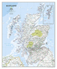

Scotland North & South A-Z Wall Map PAPER
Double-sided Wall map of North and South Scotland at 1:316, 800 (5 miles to 1 inch) from Geographers` A-Z Map Company for traditionalists who prefer their maps drawn at scales corresponding to the imperial measurements of miles to inches, with colourful presentation of topography and hill heights in feet.Presentation of the topography varies slightly, from bold altitude colouring in older editions to slightly gentler colours enhanced by relief shading on more recent maps, both very effectively showing the more hilly or mountainous parts of the country. All maps have spot heights shown in feet.The colouring of the road network clearly distinguishes between primary routes and other A roads for route planning, with B roads also easy to follow on all backgrounds. Smaller country roads are
less clear to see, with the publishers recommending their alternative series for more detailed local coverage. Railway lines are included and shown with stations, but at times difficult to find. British national grid lines are overprinted on the cartography and a separate booklet is supplied containing the index to cities, towns, villages, hamlets and locations.* *IMPORTANT - PLEASE NOTE: many place names and all additional tourist information is in very small lettering, requiring good eyesight or a magnifying glass.*
less clear to see, with the publishers recommending their alternative series for more detailed local coverage. Railway lines are included and shown with stations, but at times difficult to find. British national grid lines are overprinted on the cartography and a separate booklet is supplied containing the index to cities, towns, villages, hamlets and locations.* *IMPORTANT - PLEASE NOTE: many place names and all additional tourist information is in very small lettering, requiring good eyesight or a magnifying glass.*
Product Description
Reviews/Comments
Add New
Vouchers
No voucher codes found.
Do you know a voucher code for this product or supplier? Add it to Insights for others to use.
Do you know a voucher code for this product or supplier? Add it to Insights for others to use.
 Denmark