
 United Kingdom
 France
 Germany
 Netherlands
 Sweden
 USA
USA
 Italy
Italy
 Spain
Spain
More From Contributor


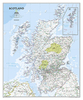

Scotland Mountain Range Guide
Cicerone’s Scotland Mountain Range Guide is full of route and practical information for the independent mountain lover, whether with a view to walking, climbing, scrambling or ski touring in terrain such as the Southern Uplands, the great granite plateaus of the Cairngorms and the jagged arêtes of the Cuillin hills on the Isle of Skye.Descriptions are provided on all Scottish mountains, arranged area-by-area from south to north, including classic ascents up Ben Nevis. Comprehensive information is provided on routes, aswell as access and bases. Appendices contain a glossary of mountain words in Gaelic and Scots, as well as a bibliography of further reading and a comprehensive list of Munros. A legend system is also used in the text; with symbols representing low-level/passes
walks, long distance walks, summit walks, scrambles, rock climbs, winter climbs, ski tours, other local points of interest, chapter highlight. Map pages, designed for pre-trip overview planning rather than use in the field, include road and topographic detail, as well as long distance footpaths and 50m contour lines. Steep gradients and spot heights are marked, as well as accommodation and visitor sights.
walks, long distance walks, summit walks, scrambles, rock climbs, winter climbs, ski tours, other local points of interest, chapter highlight. Map pages, designed for pre-trip overview planning rather than use in the field, include road and topographic detail, as well as long distance footpaths and 50m contour lines. Steep gradients and spot heights are marked, as well as accommodation and visitor sights.
Product Description
Reviews/Comments
Add New
Vouchers
No voucher codes found.
Do you know a voucher code for this product or supplier? Add it to Insights for others to use.
Do you know a voucher code for this product or supplier? Add it to Insights for others to use.
 Denmark