More From Contributor

£12.95
This work is a compact, briskly-written introduction to the history, politics & culture of Sweden, Finl&, Norway & Denmark, from the Napoleonic era to the present. It aims to diminish national stereotypes. It describes the salient events & personalities, including artists, musicians & intellectuals such as Ibsen, Bergman, Kierkegaard, Munch & Sibelius. ...
Archived Product
£140.00
Sweden & Norway, an original antique map by S.A. Mitchell, published in Philadelphia, 1846. Copperplate, original colour. Map size 25 x 30 cm, overall mounted size 40.5 x 46 cm.A detailed map of these two Scandinavian countries. Samuel Augustus Mitchell's New Universal Atlas.. . comprised finely engraved & delicately h&-coloured maps & plans of all areas of the world. Antique maps from various original publishers are presented on the Stanford ...
Archived Product
£29.99
Spiral-bound atlas of Scandinavia covering Norway, Denmark, Sweden, Finl&, the Benelux & norther Germany at a scale of 1:250, 000-400, 000. Small parts of the adjacent countries are also covered. Details combines clear road mapping with subtle hillshading & peak heights. Eight different types of roads are shown, with clearly marked road names, distances between junctions, gradients, service stations, parkings & motels. Toll roads, border crossings & scenic & tourists routes are also indicated. Railways, ferry lines, & national & provincial boundaries are marked alongside national parks & military areas. Also a series of symbols depicts places of interest, viewpoints, airports & harbours, campings, archeological sites & mountain huts. Following the main mapping is an extensive index with postal codes, & 33 street plans of major town centres at 1:15, 000 with corresponding indexes. All Legends are in 8 different languages including English. ...
Archived Product
£16.99
Scandinavia Insight Guide is dedicated to exploring the destination in detail with a selection of glossy illustrations. Extensive introductory sections explore the region’s history & culture & there are also short articles written by locals about distinctive local issues, whilst selective photo-features illustrate the variety of the place. The ‘ Places’ section is grouped geographically & provides details of the area including places to visit, suggestions for tours & other activities. Each section has its own listings of the best restaurants, bars & cafes. Essential practical information is provided in the Travel Tips chapter on accommodation, shopping & local activities. A useful location finder & travel tip index with relevant page numbers are given on the inside covers. Overview street plans are also provided for the main cities in the region or country. ...
Archived Product
£9.99
Scandinavia at 1:1, 350, 000 on an indexed map from ITMB, presenting on one side Denmark with southern Norway & Sweden, & on the reverse, with an overlap between the sides, northern Norway & Sweden with Finl&. Road & rail networks are shown on a single-colour green background, with topography indicated only by spot heights. Also marked are selected ferry connections annotated with the duration of transit. Symbols indicate various places of interest & facilities; the map also shows national parks & restricted entry zones. Latitude & longitude lines are drawn at 1º & 2º respectively. Each side has a separate index. ...
Archived Product
£12.99
Scandinavia at 1:2, 765, 000 on a wall map,

Size:
77 x 60cm (30” x 24” approx) – paper version, from the

...
Archived Product
£15.99
You can count on Rick Steves to tell you what you really need to know when travelling in Denmark, Norway, Sweden, Finl&, & Estonia. With this guide, you`ll set sail to Europe`s most prosperous corner--a smorgasbord of Viking ships, deep green fjords, stave churches, brooding castles, & colourful farmhouses. Explore the sleek, modern capital cities of Copenhagen, Oslo, Stockholm, Helsinki, & Tallinn. Cruise through Stockholm`s scenic archipelago, & sample the Baltic charms of Tallinn. Delve deep into Norway`s scenic Sognefjord & bike through the idyllic Danish countryside on the castaway island of Aero. & take some time out from sightseeing to get your blood pumping in a steamy Finnish sauna. The author himself has comprehensively researched each title, lending the recommendations in each guide a more personal air than guides that are researched by a team of writers. Each title is arranged geographically by region, area & city, with each section giving details on orientation, tourist information, ‘helpful hints’, getting around, local tours on foot or by car, day trips, principal sights, activities, recommended experiences, nightlife, sleeping, eating & transport connections. H&-drawn overview maps lend each guide a more personal touch. An introductory paragraph also introduces readers to the destination, with guidance on pre-trip planning, practicalities, money, sightseeing, sleeping, eating, ‘travelling as a temporary local’ & ‘back door travel philosophy’. An appendix also offers information on communication, transportation, resources, holidays & festivals, conversions & climate, a packing checklist & essential vocabulary. *A number of Rick Steves’ guides are updated annually. Please see individual titles for further information; they will carry the year in the title of the guidebook.’* ...
Archived Product
£26.00
Here are authentic Scandinavian recipes with a modern twist, shot on location in Scandinavia. The book is suffused with `hygge`, ...
Archived Product
£16.99
In Scandinavia the whole period of Christmas, from the first Sunday in Advent to New Year`s Day, is marked by festivals & celebrated in traditional but beautifully contemporary style. Hygge, the Danish word for cosiness, is about being inside with candles, great comfort food & lots of cakes & sweets. The first week of December is baking week
- enough has to be made to last the whole Christmas period. Jars of decorated cookies, gingerbread houses & clogs filled with little presents rub shoulders with simple wreaths, trees & tables decorated with white candles & fresh greenery
- the perfect mix of ancient & modern. Brunches, cocktail & tea parties, lunches & dinners are celebrated with a mixture of traditional goodies & delicious modern recipes. Duck & pork rule on Christmas Eve, fish, ham & seasonal vegetables on Christmas Day. Sweets, biscuits, puddings & other treats abound
- all washed down with gluwein & fruity cocktails. In this glorious book, illustrated with Lars Ranek`s evocative photographs, Trine Hahnemann provides a cornucopia of 70 Christmas recipes
- all featuring ingredients which are common to all northern climes
- showing us how we, too, can decorate our homes & make delicious dishes to celebrate Christmas the Scandinavian way.


...
Archived Product
£25.00
The Scandinavians excel in comfort
- family, friends, a good atmosphere, long meals, relaxation & an emphasis on simple pleasures.
...
Archived Product

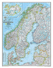
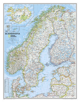
Scandinavia NGS Classic Wall Map ENCAPSULATED

Scandinavia at 1:2, 765, 000 on a wall map, size: 77 x 60cm (30” x 24” approx) – encapsulated version, from the National Geographic Society in their traditional classic style with a light base and country boundaries in bright colours.Coverage includes the whole of the Baltic Sea, Estonia, Latvia and Lithuania. Insets show Iceland, Faroe Islands and Jan Mayen (but not Svalbard).The map shows the network of main roads and railways, airports and ferry routes. Topography is indicated by light relief shading, with spot heights and graphics for swamp areas, and in Iceland glaciers and lava fields, plus names of various mountain ranges, etc. Main national parks are highlighted. A glossary provides a translation of various geographical terms. Latitude and longitude lines are drawn
at 2° intervals.* This map is also available on paper without the encapsulation.
RIP - This product is no longer available on our network. It was last seen on 25.09.2019

This page now acts as a permanent archive for this product. Add more information using the comments box below to ensure it can still be found by future generations.

Use our search facility to see if it is available from an alternative contributor.
  • Availability: Out Of Stock
  • Supplier: Stanfords
  • SKU: 9780792292678
Availability: In Stock
£16.99

Product Description

Scandinavia at 1:2, 765, 000 on a wall map,

Size:
77 x 60cm (30” x 24” approx) – encapsulated version, from the National Geographic Society in their traditional classic style with a light base & country boundaries in bright colours. Coverage

Includes::
the whole of the Baltic Sea, Estonia, Latvia & Lithuania. Insets show Icel&, Faroe Islands & Jan Mayen (but not Svalbard). The map shows the network of main roads & railways, airports & ferry routes. Topography is indicated by light relief shading, with spot heights & graphics for swamp areas, & in Iceland glaciers & lava fields, plus names of various mountain ranges, etc. Main national parks are highlighted. A glossary provides a translation of various geographical terms. Latitude & longitude lines are drawn at 2° intervals.* This map is also available on paper without the encapsulation.

Reviews/Comments

Add New

Intelligent Comparison

Oooops!
We couldn't find anything!
Perhaps this product's unique.... Or perhaps we are still looking for comparisons!
Click to bump this page and we'll hurry up.

Price History

Vouchers

No voucher codes found.
Do you know a voucher code for this product or supplier? Add it to Insights for others to use.

Facebook

Jargon Buster

Paper - A thin sheet mainly used for writing. Available in a variety of colours. Made mainly from wood pulp.
Graphics - A general term for visual aspects of an item/display
Wall - A physical barrier between two areas
Railways - A set of tracks that have been laid for the purpose of trains to travel up and down them
Size - is the measurement of how big an object is in space.
Network - A link and communication between things. Often computers or people.
Traditional - Something that has become the same through a period of time and thus repeated.
Traditional - Something that has been around for a while and is repeated regularly.
Classic - Something that is still like it was originally a high quality standard.

Supplier Information

Stanfords
Stanfords was established in 1853 and opened their iconic Covent Garden flagship store in 1901. They have become the top retailer of maps, travel books and accessories in the UK and arguably offer the largest selection of maps and travel books worldwide. Famous names such as Captain Robert Falcon Scott, Ranulph Fiennes and Michael Palin have purchased from Stanfords. They now have a shop in Bristol and both stores together with other venues operate a calendar of events including talks, book signings and exhibitions. As a specialist map retailer, the map selection is comprehensive and includes road maps, street maps and walking maps from worldwide destinations, as well as a selection of world atlases and wall maps. Books include travel guides and travel literature. Stanfords also stock globes, from miniatures made of blue marble to magnificent floor-standing globes. The website features a selection of interesting articles on travel topics.
Page Updated: 2023-11-12 20:15:36

Community Generated Product Tags

Oh No! The productWIKI community hasn't generated any tags for this product yet!
Menu