
 United Kingdom
 France
 Germany
 Netherlands
 Sweden
 USA
USA
 Italy
Italy
 Spain
Spain
More From Contributor


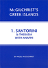


Santorini - Thirasia Anavasi 10.24
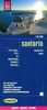
Santorini with the nearby Thirasia at 1:26, 000 on light, waterproof and tear-resistant, contoured and GPS compatible map from Anavasi, with on the reverse special maps of the two islands highlighting numerous hiking paths.On one side the two islands, with Nea Kameni, Palea Kameni and Aspronisi, are presented with contours at 20 metre intervals with additional altitude colouring. Road network indicates dirt roads in poor condition, gives distances on most small local roads, and shows locations of petrol stations. Symbols highlight various places of interest, including beaches and scuba diving sites, campsites, archaeological remains, etc. Place names are in both Greek and Latin alphabet. The map has a 1-km UTM grid plus latitude and longitude crosshairs at 1’ intervals.On the
reverse are slightly simplified maps of the two islands highlighting numerous hiking options, 19 on Santorini and 6 on Thirasia, each accompanied by a brief description. Map legend and all the text include English.To see which other Greek islands are covered by maps from Anavasi, please click on the series link.
reverse are slightly simplified maps of the two islands highlighting numerous hiking options, 19 on Santorini and 6 on Thirasia, each accompanied by a brief description. Map legend and all the text include English.To see which other Greek islands are covered by maps from Anavasi, please click on the series link.

Product Description
Reviews/Comments
Add New
Vouchers
No voucher codes found.
Do you know a voucher code for this product or supplier? Add it to Insights for others to use.
Do you know a voucher code for this product or supplier? Add it to Insights for others to use.
 Denmark