
 United Kingdom
 France
 Germany
 Netherlands
 Sweden
 USA
USA
 Italy
Italy
 Spain
Spain
More From Contributor


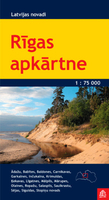
Riga And Environs
The environs of Riga on a double-sided map at 1:75, 000 from the locally-based Jana Seta publishers with detailed presentation of terrain and the road or rail networks, places of interest and tourist facilities, etc.The map is double-sided, with a generous overlap and Riga itself included on both sides. Topography and landscape are shown by contours at 10m intervals, numerous spot heights, and colouring/graphics for different types of land use or terrain (orchards, forests, swamps, etc). Finely graded road network indicates “difficult to travel unsurfaced roads”, shows driving distances on main and secondary routes, and indicates locations of petrol stations. Railway lines are shown with stations and stops; the map also shows narrow gauge lines and abandoned routes.
Interesting locations are highlighted and symbols indicate hotels and other tourist accommodation, campsites, viewpoints, hills and interesting natural sites, etc. The map has latitude and longitude lines at 5’ and 10’ respectively. Map legend includes English.To see the other titles in this series please click on the series link.
Interesting locations are highlighted and symbols indicate hotels and other tourist accommodation, campsites, viewpoints, hills and interesting natural sites, etc. The map has latitude and longitude lines at 5’ and 10’ respectively. Map legend includes English.To see the other titles in this series please click on the series link.

Product Description
Reviews/Comments
Add New
Vouchers
No voucher codes found.
Do you know a voucher code for this product or supplier? Add it to Insights for others to use.
Do you know a voucher code for this product or supplier? Add it to Insights for others to use.
 Denmark