
 United Kingdom
 France
 Germany
 Netherlands
 Sweden
 USA
USA
 Italy
Italy
 Spain
Spain
More From Contributor


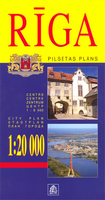
Riga
Riga street plan from Latvia’s leading map publishers Jana Seta, presenting the city with its outer suburbs at 1:20, 000, plus a more detailed plan of the historic town centre and the adjoining districts at 1:7, 000.The main plan presents Riga with its outer suburbs, with northern and southernmost parts of the city shown as insets. Streets are annotated with selected house numbers for easy identification of addresses. Tram, trolleybus and bus routes indicate stops and line numbers and railways are shown with names of local stations. The plan shows one way streets, car parks, and locations of petrol stations. Main through routes are highlighted and motorway junctions clearly laid out. Symbols highlight hotels and other accommodation, campsites, museums, churches, markets, etc.
An enlargement shows the city’s historic centre and the adjoining districts in greater detail. Map legend includes English. Street index is in a separate booklet attached to the map cover.
An enlargement shows the city’s historic centre and the adjoining districts in greater detail. Map legend includes English. Street index is in a separate booklet attached to the map cover.

Product Description
Reviews/Comments
Add New
Vouchers
No voucher codes found.
Do you know a voucher code for this product or supplier? Add it to Insights for others to use.
Do you know a voucher code for this product or supplier? Add it to Insights for others to use.
 Denmark