More From Contributor
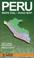
£15.99
With its astounding natural diversity, eclectic blend of cultures & outdoor activities of all kinds, Peru is endlessly surprising. Be inspired to visit this enthralling country with our updated edition of Insight Guides Peru.- Over 345 pages of insider knowledge from local experts- In-depth on history & culture, from the Incas to life in the Andes, Peruvian crafts & wildlife
- Enjoy special features on the Amazon by riverboat, jungle lodges & pottery, to name a few-

Includes::
innovative extras that are unique in the market
- all Insight Guides to countries & regions come with a free e Book & app that`s regularly updated with new hotel, bar, restaurant, shop & local event listings- Invaluable maps, travel tips & practical information ensure effortless planning
- Inspirational colour photography throughout- Inventive design makes for an engaging reading experience


...
Archived Product
£7.99
Peru in the Pocket Guide series from Insight provides detailed commentary on a collection of itinerary based trips in a handy pocket format. Each guide has an historical & cultural introduction, profiling the growth of the region or city. There is also a large selection of localised & pedestrian friendly tour itineraries designed to take in the major sites, as well as a chapter on excursions to other destinations within easy reach. Further sections detail leisure activities including shopping, eating out, nightlife, festivals & local events with accompanying addresses & contact details where relevant. There is also practical guidance on transport, local services, language & accommodation. Each guide also has a large selection of colour photographs & a pull-out pocket map giving an overview of the region. ...
Archived Product
£9.99
Peru at 1:1, 500, 000 on a double-sided, waterproof & tear-resistant, indexed map from ITMB, with large, clear street plans of central Lima & Cusco, highlighting accommodation, places of interest & various facilities. The map divides the country north/south, Approx. along the line between the Cordillera Blanca & Cordillera Huyahuash, with very little overlap between the two sides. Topography is very effectively presented by altitude colouring, with spot heights & additional graphics for swamps & marshl&, glaciers & volcanos. The map shows the country’s road network distinguishing between all-weather & seasonable roads & indicates driving distances on main routes. Railway lines, including the popular routes linking Cusco with Puno & Arequipa, are very clearly shown. The map also shows local airports & airstrips, as well as internal administrative boundaries with names of the provinces. National parks are highlighted & symbols indicate various other places of interest, including the country archaeological sites. Latitude & longitude lines are drawn at intervals of 1°. Each side has a separate index of localities. Also included are very clear street plans of central Lima & Cusco highlighting selected accommodation, supermarkets, various institutions & places of interest, etc. ...
Archived Product
£12.95
Indexed physical road map, with street plans. The country is displayed in its entirety on one side, with hill-shading effectively showing the general relief & selected peak heights. Road detail

Includes::
unpaved roads & dirt roads, & shows intermediate driving distances on main routes. Administrative department boundaries are marked, also national parks & reserves
- although these are not particularly obvious. Symbols classify settlements according to population size. Other symbols denote airports, ports, high passes, thermal springs, archaeological sites, mines & other sites of interest to tourists. Latitude & longitude lines are at 1


...
Archived Product
£12.95
Peru at 1:2, 200, 000 on an indexed road map from the locally based Editorial Lima 2000 with 11 street plans, including metropolitan & central Lima, Cusco, Arequipa, Huaraz, Iquitos, Cajamarca, Trujillo, etc. On one side is a road map of the whole country, extending north to include Quito & east over Lake Titicaca to La Paz. Relief shading & colouring very effectively presents the country ...
Archived Product
£12.95
Small, double-sided road map dividing the country north/south. The detail is the same as that on the 1:2, 200, 000 map by this publisher, here reproduced at a slightly larger scale. Hill-shading effectively shows the general relief & selected peak heights are marked. Road detail

Includes::
unpaved roads & dirt roads, & shows intermediate driving distances on main routes. Administrative department boundaries are marked, also national parks & reserves
- although these are not particularly obvious. Symbols classify settlements according to population size. Other symbols denote airports, ports, high passes, thermal springs, archaeological sites, mines & other sites of interest to tourists. Latitude & longitude lines are at 1


...
Archived Product
£9.99
Small, double-sided road map dividing the country north/south. The detail is the same as that on the 1:2, 200, 000 map by this publisher, here reproduced at a slightly larger scale. Hill-shading effectively shows the general relief & selected peak heights are marked. Road detail

Includes::
unpaved roads & dirt roads, & shows intermediate driving distances on main routes. Administrative department boundaries are marked, also national parks & reserves
- although these are not particularly obvious. Symbols classify settlements according to population size. Other symbols denote airports, ports, high passes, thermal springs, archaeological sites, mines & other sites of interest to tourists. Latitude & longitude lines are at 1° intervals. The legend is in Spanish & English.


...
Archived Product
£5.99
Peru at 1:1, 500, 000 on a large, indexed, double-sided map from Michelin with very clear presentation of the country’s topography, detailed grading of the road network, places of interest, plus a street plan of central Lima. The map divides the country north/south with a good overlap between the two sides. Coverage of the southern side

Includes::
Cordillera Blanca, so all the country’s most visited regions are presented on one side of the map. The northern side extends north to Quito. Vivid relief shading presents the topography, with plenty of names of mountain ranges & main peaks. National parks & other protected areas are marked. Road network indicates all-weather surfaces or unsurfaced routes & unsurfaced roads suitable only for 4WD vehicles. Driving distances are marked on many secondary routes. Railway lines are included & local airports are marked. Places of interest are clearly highlighted, with special symbols for Inca ruins & UNESCO World Heritage sites. The map also shows pipelines as well the internal administrative borders with names of the departments. Latitude & longitude lines are drawn at intervals of 1º. Map legend

Includes::
English. The map is indexed &

Includes::
a street plan of central Lima highlighting the city’s main sights, a distance table, plus basic driving regulations.


...
Archived Product
£11.50
Peru at 1:1, 500, 000 on an indexed, waterproof & tear-resistant road map with topographic & tourist information, published by Reise Know-How as part of their highly acclaimed World Mapping Project. The map is double-sided to provide the best balance between a good scale & a convenient size sheet. Coverage extends north to Quito. The country’s topography is presented by altitude colouring with contours, spot heights, & plenty of names of mountain range, peaks, etc. National parks & other protected areas are highlighted. Road network, clear to see against the background colouring, indicates unsurfaced local roads & 4WD tracks, & gives driving distances on main routes. Railway lines & ferry connections on Lake Titicaca are included & local airports/airfields are marked. The map also shows internal administrative boundaries with names of the provinces. Symbols highlight various places of interest, including UNESCO world heritage sites, archaeological remains, beaches, etc. The map has a latitude & longitude grid at intervals of 1° & an extensive index of localities with a separate list of protected areas. Map legend

Includes::
English.” World Mapping Project” is an extensive series of maps at varying scales, aiming to provide coverage of countries & regions worldwide using clear, well presented cartography with both topographic & tourist information.

...
Archived Product

Peru Mapa Vial

Peru at 1:2, 200, 000 on an indexed road map from the locally based Editorial Lima 2000 with 11 street plans, including metropolitan and central Lima, Cusco, Arequipa, Huaraz, Iquitos, Cajamarca, Trujillo, etc.On one side is a road map of the whole country, extending north to include Quito and east over Lake Titicaca to La Paz. Relief shading and colouring very effectively presents the country’s topography, with names of main mountain ranges and peaks. The map also shows boundaries of protected areas. Road network indicates paved and unpaved roads and includes dirt tracks, with driving distances shown on all routes. Railway lines are included and local airports are marked. Also shown are internal administrative divisions into departments. Small symbols mark archaeological
sites. Latitude and longitude lines are drawn at 1° intervals. The index, on the reverse side, includes lists of principal points of interest, plus rivers and lakes. Map legend includes English.On the reverse is a large street plan of metropolitan Lima, plus 11 panels with city centre street plans of Lima, Cusco, Arequipa, Ica, Iquitos, Huancayo, Huaraz, Piura, Chiclayo, Trujillo and Cajamarca. The plans highlight main traffic arteries and principal buildings. Also provided is a distance table.
RIP - This product is no longer available on our network. It was last seen on 25.09.2019

This page now acts as a permanent archive for this product. Add more information using the comments box below to ensure it can still be found by future generations.

Use our search facility to see if it is available from an alternative contributor.
  • External links may include paid for promotion
  • Availability: Out Of Stock
  • Supplier: Stanfords
  • SKU: 9789972654541
Availability: In Stock
£11.99

Product Description

Peru at 1:2, 200, 000 on an indexed road map from the locally based Editorial Lima 2000 with 11 street plans, including metropolitan & central Lima, Cusco, Arequipa, Huaraz, Iquitos, Cajamarca, Trujillo, etc. On one side is a road map of the whole country, extending north to include Quito & east over Lake Titicaca to La Paz. Relief shading & colouring very effectively presents the country’s topography, with names of main mountain ranges & peaks. The map also shows boundaries of protected areas. Road network indicates paved & unpaved roads &

Includes::
dirt tracks, with driving distances shown on all routes. Railway lines are included & local airports are marked. Also shown are internal administrative divisions into departments. Small symbols mark archaeological sites. Latitude & longitude lines are drawn at 1° intervals. The index, on the reverse side,

Includes::
lists of principal points of interest, plus rivers & lakes. Map legend

Includes::
English. On the reverse is a large street plan of metropolitan Lima, plus 11 panels with city centre street plans of Lima, Cusco, Arequipa, Ica, Iquitos, Huancayo, Huaraz, Piura, Chiclayo, Trujillo & Cajamarca. The plans highlight main traffic arteries & principal buildings. Also provided is a distance table.

Reviews/Comments

Add New

Intelligent Comparison

Oooops!
We couldn't find anything!
Perhaps this product's unique.... Or perhaps we are still looking for comparisons!
Click to bump this page and we'll hurry up.

Price History

Vouchers

No voucher codes found.
Do you know a voucher code for this product or supplier? Add it to Insights for others to use.

Facebook

Jargon Buster

Network - A link and communication between things. Often computers or people.
Large - something that takes up more space than normal.
Small - something that takes up less space than normal.
Road - a manmade lane or a path that is used to speed up travel.

Supplier Information

Stanfords
Stanfords was established in 1853 and opened their iconic Covent Garden flagship store in 1901. They have become the top retailer of maps, travel books and accessories in the UK and arguably offer the largest selection of maps and travel books worldwide. Famous names such as Captain Robert Falcon Scott, Ranulph Fiennes and Michael Palin have purchased from Stanfords. They now have a shop in Bristol and both stores together with other venues operate a calendar of events including talks, book signings and exhibitions. As a specialist map retailer, the map selection is comprehensive and includes road maps, street maps and walking maps from worldwide destinations, as well as a selection of world atlases and wall maps. Books include travel guides and travel literature. Stanfords also stock globes, from miniatures made of blue marble to magnificent floor-standing globes. The website features a selection of interesting articles on travel topics.
Page Updated: 2023-11-12 20:15:36

Community Generated Product Tags

Oh No! The productWIKI community hasn't generated any tags for this product yet!
Menu