More From Contributor

£11.99
Peru at 1:2, 200, 000 on an indexed road map from the locally based Editorial Lima 2000 with 11 street plans, including metropolitan & central Lima, Cusco, Arequipa, Huaraz, Iquitos, Cajamarca, Trujillo, etc. On one side is a road map of the whole country, extending north to include Quito & east over Lake Titicaca to La Paz. Relief shading & colouring very effectively presents the country’s topography, with names of main mountain ranges & peaks. The map also shows boundaries of protected areas. Road network indicates paved & unpaved roads &

Includes::
dirt tracks, with driving distances shown on all routes. Railway lines are included & local airports are marked. Also shown are internal administrative divisions into departments. Small symbols mark archaeological sites. Latitude & longitude lines are drawn at 1° intervals. The index, on the reverse side,

Includes::
lists of principal points of interest, plus rivers & lakes. Map legend

Includes::
English. On the reverse is a large street plan of metropolitan Lima, plus 11 panels with city centre street plans of Lima, Cusco, Arequipa, Ica, Iquitos, Huancayo, Huaraz, Piura, Chiclayo, Trujillo & Cajamarca. The plans highlight main traffic arteries & principal buildings. Also provided is a distance table.


...
Archived Product
£12.95
Small, double-sided road map dividing the country north/south. The detail is the same as that on the 1:2, 200, 000 map by this publisher, here reproduced at a slightly larger scale. Hill-shading effectively shows the general relief & selected peak heights are marked. Road detail

Includes::
unpaved roads & dirt roads, & shows intermediate driving distances on main routes. Administrative department boundaries are marked, also national parks & reserves
- although these are not particularly obvious. Symbols classify settlements according to population size. Other symbols denote airports, ports, high passes, thermal springs, archaeological sites, mines & other sites of interest to tourists. Latitude & longitude lines are at 1


...
Archived Product
£9.99
Small, double-sided road map dividing the country north/south. The detail is the same as that on the 1:2, 200, 000 map by this publisher, here reproduced at a slightly larger scale. Hill-shading effectively shows the general relief & selected peak heights are marked. Road detail

Includes::
unpaved roads & dirt roads, & shows intermediate driving distances on main routes. Administrative department boundaries are marked, also national parks & reserves
- although these are not particularly obvious. Symbols classify settlements according to population size. Other symbols denote airports, ports, high passes, thermal springs, archaeological sites, mines & other sites of interest to tourists. Latitude & longitude lines are at 1° intervals. The legend is in Spanish & English.


...
Archived Product
£5.99
Peru at 1:1, 500, 000 on a large, indexed, double-sided map from Michelin with very clear presentation of the country’s topography, detailed grading of the road network, places of interest, plus a street plan of central Lima. The map divides the country north/south with a good overlap between the two sides. Coverage of the southern side

Includes::
Cordillera Blanca, so all the country’s most visited regions are presented on one side of the map. The northern side extends north to Quito. Vivid relief shading presents the topography, with plenty of names of mountain ranges & main peaks. National parks & other protected areas are marked. Road network indicates all-weather surfaces or unsurfaced routes & unsurfaced roads suitable only for 4WD vehicles. Driving distances are marked on many secondary routes. Railway lines are included & local airports are marked. Places of interest are clearly highlighted, with special symbols for Inca ruins & UNESCO World Heritage sites. The map also shows pipelines as well the internal administrative borders with names of the departments. Latitude & longitude lines are drawn at intervals of 1º. Map legend

Includes::
English. The map is indexed &

Includes::
a street plan of central Lima highlighting the city’s main sights, a distance table, plus basic driving regulations.


...
Archived Product
£8.99
The highly successful Globetrotter Travel Series, which

Includes::
Travel Guides, Travel Maps, Road Atlases,

...
Archived Product
£17.99
Peru in the National Geographic Traveler guide series, produced by America’s leading travel publishers, exploring a range of cities, regions & countries worldwide & using the expertise & tradition of National Geographic to provide a comprehensive survey of each destination. Each of the guides in the series draws upon National Geographic’s rich history of travel experience & is researched by authors familiar with the area. Whilst the content is influenced by an American editorial style, individual titles are still accessible to a non-American audience, with a combination of practical guidance & detailed information included in each guide. The series also relies upon the extensive image libraries of National Geographic to present a rich visual image of each destination. Individual National Geographic Traveler titles are organised uniformly, allowing readers to access information quickly & easily. Introductory sections provide information on Charting your Trip, with details of getting there & around & a History & Culture chapter profiling history, food & drink, land & landscape, flora & fauna & arts & literature. Chapter are arranged geographically by region, with notable cities & areas principally describing the main sites & attractions, with further information on directions, history & practicalities. There are also a number of individual features & insider tips throughout each guide covering subjects such as walking tours, local culture, driving tours, recommended local experiences & in-depth thematic short histories of the culture & histories of individual regions. A Travelwise section at the back of each guide provides essential practical information on when to go, what to take, further reading, getting there & around, local etiquette, media, holidays, money matters, religion, smoking, time differences, opening times, travellers with disabilities & accommodation. Restaurants & hotels are listed with brief descriptions & information on prices, location, contact details & facilities for the relevant regional chapters in the guide. ...
Archived Product
£16.99
Linked by the sinuous spine of the Andes, Peru, Bolivia & Ecuador are born of a synthesis of ancient America & medieval Europe. Footprint`s Peru, Bolivia & Ecuador Handbook will guide you from the unforgettably unique Galapagos Islands, through the awe-inspiring citadel of Machu Picchu, to the shimmering turquoise waters of Lake Titicaca. Great coverage of the top activities & sights in the region, including the colonial treasures of Quito; spectacular costumed festivals; sacred pyramids & temples; the incredible salt flats of Salar de Uyunia Loaded with information & suggestions on how to get off the beaten track, from where to find the best artesania to seeking jaguars in the rainforest.
Includes: comprehensive information on everything from transport & racticalities to history, culture & landscape Plus all the usual accommodation, eating & drinking listings for every budget Full-colour planning section to inspire travellers & help them find the best experiences From the mysterious Nazca lines to bustling indigenous markets, Footprint`s fully updated 5th edition will help you navigate this breathtaking destination.
...
Archived Product
£15.99
Peru, Bolivia & Ecuador in the Handbooks series from Footprint; comprehensive & leading guides designed & written for independent travellers who enjoy exploring off the beaten track. Footprint guides have an established reputation, built up since 1921, for catering for more adventurous & individual travellers. An unrestrictive editorial style also gives authors the freedom to capture & explore local cultures, sights & areas that are often not covered in other guides. Widely recognised for their reliability & independent writing style, Footprint guides all have the same layout. Introductory sections introduce the reader to the destination, with chapters on planning on your trip & essentials, including practical information & guidance on subjects such as when & where to go, itineraries, sport & activities, arts, getting there & around, eating & drinks, sleeping & a dedicated section on the anticipated carbon footprint involved in travelling to the destination. Each guide is organised geographically by region or country, with individual sections having a particular focus on an extensive range of sights & places of interest. Further, there are also details of accommodation, nightlife, restaurants & any notable local activities. Information boxes throughout the text give readers an insight into local customs, stories & sights of particular interest.A ...
Archived Product
£15.99
Tracing the range of the Andes
- the geographical & cultural spine of South America
- Peru, Bolivia & Ecuador are born of a

...
Archived Product

Peru Reise Know-How

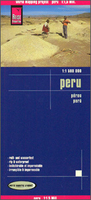
Peru at 1:1, 500, 000 on an indexed, waterproof and tear-resistant road map with topographic and tourist information, published by Reise Know-How as part of their highly acclaimed World Mapping Project. The map is double-sided to provide the best balance between a good scale and a convenient size sheet. Coverage extends north to Quito.The country’s topography is presented by altitude colouring with contours, spot heights, and plenty of names of mountain range, peaks, etc. National parks and other protected areas are highlighted. Road network, clear to see against the background colouring, indicates unsurfaced local roads and 4WD tracks, and gives driving distances on main routes. Railway lines and ferry connections on Lake Titicaca are included and local airports/airfields are
marked. The map also shows internal administrative boundaries with names of the provinces. Symbols highlight various places of interest, including UNESCO world heritage sites, archaeological remains, beaches, etc. The map has a latitude and longitude grid at intervals of 1° and an extensive index of localities with a separate list of protected areas. Map legend includes English.”World Mapping Project” is an extensive series of maps at varying scales, aiming to provide coverage of countries and regions worldwide using clear, well presented cartography with both topographic and tourist information.
RIP - This product is no longer available on our network. It was last seen on 25.09.2019

This page now acts as a permanent archive for this product. Add more information using the comments box below to ensure it can still be found by future generations.

Use our search facility to see if it is available from an alternative contributor.
  • External links may include paid for promotion
  • Availability: Out Of Stock
  • Supplier: Stanfords
  • SKU: 9783831772803
Availability: In Stock
£11.50

Product Description

Peru at 1:1, 500, 000 on an indexed, waterproof & tear-resistant road map with topographic & tourist information, published by Reise Know-How as part of their highly acclaimed World Mapping Project. The map is double-sided to provide the best balance between a good scale & a convenient size sheet. Coverage extends north to Quito. The country’s topography is presented by altitude colouring with contours, spot heights, & plenty of names of mountain range, peaks, etc. National parks & other protected areas are highlighted. Road network, clear to see against the background colouring, indicates unsurfaced local roads & 4WD tracks, & gives driving distances on main routes. Railway lines & ferry connections on Lake Titicaca are included & local airports/airfields are marked. The map also shows internal administrative boundaries with names of the provinces. Symbols highlight various places of interest, including UNESCO world heritage sites, archaeological remains, beaches, etc. The map has a latitude & longitude grid at intervals of 1° & an extensive index of localities with a separate list of protected areas. Map legend

Includes::
English.” World Mapping Project” is an extensive series of maps at varying scales, aiming to provide coverage of countries & regions worldwide using clear, well presented cartography with both topographic & tourist information.

Reviews/Comments

Add New

Intelligent Comparison

Oooops!
We couldn't find anything!
Perhaps this product's unique.... Or perhaps we are still looking for comparisons!
Click to bump this page and we'll hurry up.

Price History

Vouchers

No voucher codes found.
Do you know a voucher code for this product or supplier? Add it to Insights for others to use.

Facebook

Jargon Buster

Waterproof - Resistant to water, usualy specified by depth in metres
World - A physical grouping, commonly used to describe earth and everything associated with ti
Size - is the measurement of how big an object is in space.
Network - A link and communication between things. Often computers or people.
Road - a manmade lane or a path that is used to speed up travel.
Resistant - Something that can repel against something.
Altitude - Something that can be quite high in relation to sea or ground level.
Balance - Something that is evenly weighted to keep something upright.
Convenient - Something that suits and fits well to other activities.

Supplier Information

Stanfords
Stanfords was established in 1853 and opened their iconic Covent Garden flagship store in 1901. They have become the top retailer of maps, travel books and accessories in the UK and arguably offer the largest selection of maps and travel books worldwide. Famous names such as Captain Robert Falcon Scott, Ranulph Fiennes and Michael Palin have purchased from Stanfords. They now have a shop in Bristol and both stores together with other venues operate a calendar of events including talks, book signings and exhibitions. As a specialist map retailer, the map selection is comprehensive and includes road maps, street maps and walking maps from worldwide destinations, as well as a selection of world atlases and wall maps. Books include travel guides and travel literature. Stanfords also stock globes, from miniatures made of blue marble to magnificent floor-standing globes. The website features a selection of interesting articles on travel topics.
Page Updated: 2023-11-12 20:15:36

Community Generated Product Tags

Oh No! The productWIKI community hasn't generated any tags for this product yet!
Menu