
 United Kingdom
 France
 Germany
 Netherlands
 Sweden
 USA
USA
 Italy
Italy
 Spain
Spain
More From Contributor

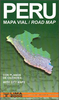


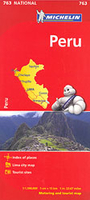
Peru Michelin
Peru at 1:1, 500, 000 on a large, indexed, double-sided map from Michelin with very clear presentation of the country’s topography, detailed grading of the road network, places of interest, plus a street plan of central Lima.The map divides the country north/south with a good overlap between the two sides. Coverage of the southern side includes Cordillera Blanca, so all the country’s most visited regions are presented on one side of the map. The northern side extends north to Quito.Vivid relief shading presents the topography, with plenty of names of mountain ranges and main peaks. National parks and other protected areas are marked. Road network indicates all-weather surfaces or unsurfaced routes and unsurfaced roads suitable only for 4WD vehicles. Driving distances are marked
on many secondary routes. Railway lines are included and local airports are marked. Places of interest are clearly highlighted, with special symbols for Inca ruins and UNESCO World Heritage sites. The map also shows pipelines as well the internal administrative borders with names of the departments. Latitude and longitude lines are drawn at intervals of 1º. Map legend includes English.The map is indexed and includes a street plan of central Lima highlighting the city’s main sights, a distance table, plus basic driving regulations.
on many secondary routes. Railway lines are included and local airports are marked. Places of interest are clearly highlighted, with special symbols for Inca ruins and UNESCO World Heritage sites. The map also shows pipelines as well the internal administrative borders with names of the departments. Latitude and longitude lines are drawn at intervals of 1º. Map legend includes English.The map is indexed and includes a street plan of central Lima highlighting the city’s main sights, a distance table, plus basic driving regulations.

Product Description
Reviews/Comments
Add New
Vouchers
No voucher codes found.
Do you know a voucher code for this product or supplier? Add it to Insights for others to use.
Do you know a voucher code for this product or supplier? Add it to Insights for others to use.
 Denmark