
 United Kingdom
 France
 Germany
 Netherlands
 Sweden
 USA
USA
 Italy
Italy
 Spain
Spain
More From Contributor


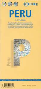
Peru Borch
Laminated, waterproof tourist map of Peru with street plans of Lima, Cuzco, Arequipa, Ayacucho and Trujillo, plus plans of the main archaeological sites. The map is double-sided, dividing the main part of the country north/south at 1:1, 750, 000, with the Amazon region shown at 1:2, 500, 000. Bold hill-shading indicates the relief, with selected peak altitudes marked. Various mountain ranges and geographical regions are named, and national parks and nature reserves are indicated. Road detail distinguishes paved and unpaved roads, includes selected tracks and shows intermediate distances on many roads. Symbols denote local airports, mountain passes, archaeological sites, museums, caves, waterfalls, lighthouses, and other sites of interest. Latitude and longitude lines are
at 1° intervals. Multilingual map legend includes English.An enlargement at 1:150, 000 covers the area of greater Lima and Callao, showing access to the international airport and highlighting beaches and places of interest. The city centre is shown on a detailed street plan at 1:18, 000, with selected hotels, main sights, etc. Two maps of Cuzco provide similar information: a more general plan 1:50, 000 plus the city centre at 1:12, 000. There are also street plans of Arequipa, Ayacucho and Trujillo. All the maps and plans are indexed for localities/streets, places of interest, etc. Also included are site plans of Machu Picchu, Chan Chan and Sacsayhuamán, a small map Peru showing administrative divisions and time zones with the neighbouring countries, and information on the
country’s climate.

Product Description
Reviews/Comments
Add New
Intelligent Comparison
Archived Product
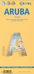
Aruba Borch Stanfords
£9.99
Archived Product

Paris Borch Stanfords
£8.99
Archived Product

Berlin Borch Stanfords
£8.99
Archived Product

Prague Borch Stanfords
£8.99
Archived Product

Jerusalem Borch Stanfords
£8.99
Vouchers
No voucher codes found.
Do you know a voucher code for this product or supplier? Add it to Insights for others to use.
Do you know a voucher code for this product or supplier? Add it to Insights for others to use.
 Denmark