
 United Kingdom
 France
 Germany
 Netherlands
 Sweden
 USA
USA
 Italy
Italy
 Spain
Spain
More From Contributor


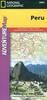

Peru And Ecuador
Peru and Ecuador at 1:2, 500, 000 from Nelles Verlag, with a smaller size sheet offering a convenient format for use when travelling. Included are several street plans of main cities, plus enlargements of popular areas of Peru. The map is double-sided, showing Ecuador with the northern and the Amazonian part of Peru on one side, with on the reverse central and southern Peru plus the adjoining parts of Bolivia with La Paz and Cordillera Real. Vivid relief shading, numerous spot heights and names of mountain ranges present the topography. National parks and other protected area are marked.Road network distinguishes between highways in good and poor condition and includes partially paved roads and cart tracks, with distances shown on main routes. Railway lines and local airports are
included, and the map also shows internal administrative boundaries with names of the provinces. Numerous places of interest are prominently marked. Latitude and longitude margin ticks are at 2
included, and the map also shows internal administrative boundaries with names of the provinces. Numerous places of interest are prominently marked. Latitude and longitude margin ticks are at 2
Product Description
Reviews/Comments
Add New
Intelligent Comparison
Archived Product

Peru, Bolivia & Ecuador Stanfords
£16.99
Archived Product

Peru - Ecuador Nelles Stanfords
£10.99
Vouchers
No voucher codes found.
Do you know a voucher code for this product or supplier? Add it to Insights for others to use.
Do you know a voucher code for this product or supplier? Add it to Insights for others to use.
 Denmark