
 United Kingdom
 France
 Germany
 Netherlands
 Sweden
 USA
USA
 Italy
Italy
 Spain
Spain
More From Contributor


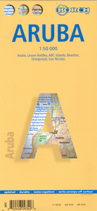
Aruba Borch
Laminated, waterproof tourist map of Aruba from Borch, with street plans of Oranjestad and San Nicolas. The main map at 1:50, 000 shows the boundaries of the Arikok National Park and highlights numerous places of interest, including beaches, shipwrecks, windsurfing and snorkeling sites, as well as information centres, petrol supplies, etc. The island’s topography is shown by relief shading with spot heights and road network includes unsurfaced country tracks. No geographical coordinates are provided. The map is supplemented by two insets with the whole of the Lesser Antilles at 1:7, 000, 000 and the ABC Islands (Aruba, Bonaire and Curaçao) at 1:1, 000, 000.On the reverse there are street plans of Oranjestad (1:10, 000) and the area north of it with the island’s main beaches
(1:25, 000), plus of the southern tip of Aruba with San Nicolas (1:20, 000), highlighting places of interest and various facilities. All the maps and the street plans are indexed, with separate lists for accommodation, beaches, places of interest, etc. Map legend includes English. Also provided is a time-zone map of the Lesser Antilles and climate charts for Aruba with average monthly temperature, precipitation, etc.
(1:25, 000), plus of the southern tip of Aruba with San Nicolas (1:20, 000), highlighting places of interest and various facilities. All the maps and the street plans are indexed, with separate lists for accommodation, beaches, places of interest, etc. Map legend includes English. Also provided is a time-zone map of the Lesser Antilles and climate charts for Aruba with average monthly temperature, precipitation, etc.

Product Description
Reviews/Comments
Add New
Intelligent Comparison
Archived Product
Cuba Borch Stanfords
£9.99
Archived Product
Peru Borch Stanfords
£9.99
Vouchers
No voucher codes found.
Do you know a voucher code for this product or supplier? Add it to Insights for others to use.
Do you know a voucher code for this product or supplier? Add it to Insights for others to use.
 Denmark