
 United Kingdom
 France
 Germany
 Netherlands
 Sweden
 USA
USA
 Italy
Italy
 Spain
Spain
More From Contributor


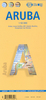

Aruba
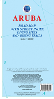
Aruba at 1:50, 000 on a light, laminated, waterproof and tear-resistant map from Berndtson, with 15 top rated sights and other tourist information, street plans of main built-up areas, maps of the surrounding region of the Caribbean, etc.The main map covers the island at 1:50, 000, showing its road network with locations of petrol stations and driving distances on main roads. 15 top sites are prominently highlighted (all provided with brief descriptions), as well as other places of interest including beaches, scuba diving/snorkeling/windsurfing sites, golf courses and other recreational facilities, national parks and wildlife reserves, etc. Topography is shown by relief shading with hill names and heights. In the surrounding coastal waters coral reefs are also marked. The map
has an index of localities and latitude/longitude grid at 0.025 of a degree.On the reverse are street plans of Oranjestad, San Nicolas and the main beach areas north of the capital, all like the main map highlighting places of interest and indexed for places, streets, points of interest, hotels, shopping centres, etc. Also provided are a map showing the
has an index of localities and latitude/longitude grid at 0.025 of a degree.On the reverse are street plans of Oranjestad, San Nicolas and the main beach areas north of the capital, all like the main map highlighting places of interest and indexed for places, streets, points of interest, hotels, shopping centres, etc. Also provided are a map showing the
Product Description
Reviews/Comments
Add New
Intelligent Comparison
Archived Product
Aruba Stanfords
£13.99
Archived Product
Arboga Stanfords
£16.99
Vouchers
No voucher codes found.
Do you know a voucher code for this product or supplier? Add it to Insights for others to use.
Do you know a voucher code for this product or supplier? Add it to Insights for others to use.
 Denmark