
 United Kingdom
 France
 Germany
 Netherlands
 Sweden
 USA
USA
 Italy
Italy
 Spain
Spain
More From Contributor


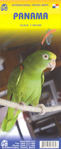
Panama ITMB
Panama at 1:300, 000 on an indexed, double-sided map from ITMB, printed on waterproof and tear-resistant plastic paper, with large, clear street plan of central Panama City highlighting various places of interest and tourist facilities.The map divides the country east/west, with some overlap between the two sides. Topography is shown by altitude colouring with spot heights and names of mountain ranges. Swaps, mangrove and salt marshes are marked, and national parks or protected areas and Indian Reserves highlighted.The map shows the country’s road network with locations of petrol stations and border crossings, plus railways and local airports or landing grounds. Internal administrative boundaries are shown with names of the provinces. Symbols highlight various places of interest,
archaeological sites, hot springs, beaches, diving or surfing sites, fishing areas, turtle protection zones, etc. Also marked is the course of the Trans-Panamanian oil pipeline. The map is indexed and has latitude and longitude lines at intervals of 30’.A large inset shows the central part of Panama City, indicating 18 selected hotels, places of interest and various facilities. Another inset extends the coverage to include the capital’s Old Town and the Causeway Islands.
archaeological sites, hot springs, beaches, diving or surfing sites, fishing areas, turtle protection zones, etc. Also marked is the course of the Trans-Panamanian oil pipeline. The map is indexed and has latitude and longitude lines at intervals of 30’.A large inset shows the central part of Panama City, indicating 18 selected hotels, places of interest and various facilities. Another inset extends the coverage to include the capital’s Old Town and the Causeway Islands.

Product Description
Reviews/Comments
Add New
Intelligent Comparison
Archived Product
Canada ITMB Stanfords
£9.99
Archived Product
Bahamas ITMB Stanfords
£9.99
Archived Product
Ghana ITMB Stanfords
£9.99
Archived Product
Paraguay ITMB Stanfords
£9.99
Archived Product
Tanzania ITMB Stanfords
£9.99
Archived Product
Zambia ITMB Stanfords
£9.99
Archived Product

Manila ITMB Stanfords
£9.99
Archived Product

Poland ITMB Stanfords
£9.99
Vouchers
No voucher codes found.
Do you know a voucher code for this product or supplier? Add it to Insights for others to use.
Do you know a voucher code for this product or supplier? Add it to Insights for others to use.
 Denmark