
 United Kingdom
 France
 Germany
 Netherlands
 Sweden
 USA
USA
 Italy
Italy
 Spain
Spain
More From Contributor


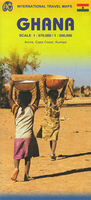
Ghana ITMB
Ghana on a double-sided indexed road map from ITMB presenting the southern part of the country at 1:500, 000 and the north at 1:570, 000, with street plans of Accra, Cape Coast and Kumasi, plus brief notes on the country’s various places of interest. The country is divided north/south, with a small overlap between the sides. Topography is shown altitude colouring and spot heights, both in feet, plus graphics for mangroves and swamps. Nature reserves and national parks are highlighted. Road network is shown with minor roads and selected local tracks, and indicates locations of fuel supplies and border crossings. Railways and local airfields are included, and ferry routes across Lake Volta are marked. The map also shows internal administrative boundaries with names of the regions.
A range of symbols indicate tourist accommodation, medical facilities, places of interest, etc. Latitude and longitude lines are drawn at 1° intervals. Each side of the map has a separate index.Street plans cover central Accra, Cape Coast, and Kumasi, showing selected accommodation facilities and restaurants, petrol stations, important governmental offices, various facilities and other locations of interest.
A range of symbols indicate tourist accommodation, medical facilities, places of interest, etc. Latitude and longitude lines are drawn at 1° intervals. Each side of the map has a separate index.Street plans cover central Accra, Cape Coast, and Kumasi, showing selected accommodation facilities and restaurants, petrol stations, important governmental offices, various facilities and other locations of interest.

Product Description
Reviews/Comments
Add New
Vouchers
No voucher codes found.
Do you know a voucher code for this product or supplier? Add it to Insights for others to use.
Do you know a voucher code for this product or supplier? Add it to Insights for others to use.
 Denmark