
 United Kingdom
 France
 Germany
 Netherlands
 Sweden
 USA
USA
 Italy
Italy
 Spain
Spain
More From Contributor

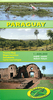


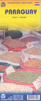
Paraguay ITMB
Paraguay on an indexed double-side map 1:800, 000 from ITMB with an enlargement for the environs of Asuncion plus a street plan of the capital’s city centre highlighting numerous hotels and various places of interest.The map divides the country east/west with a good overlap between the sides. Altitude colouring shows the topography, with swamps and marshes and national parks or other protected areas also marked. Road network gives distances on main routes and indicates locations of petrol stations. Symbols highlight places of interest, including locations with tourist accommodation and medical facilities. Also marked are internal administrative boundaries with names of the province. The map is indexed and has latitude and longitude lines at intervals of 1º.An enlargement presents the
environs of Asuncion in greater detail including access to resorts on Lago Ypacarai. The centre of the capital is shown on a clear street plan highlighting hotels and various places of interest.
environs of Asuncion in greater detail including access to resorts on Lago Ypacarai. The centre of the capital is shown on a clear street plan highlighting hotels and various places of interest.

Product Description
Reviews/Comments
Add New
Vouchers
No voucher codes found.
Do you know a voucher code for this product or supplier? Add it to Insights for others to use.
Do you know a voucher code for this product or supplier? Add it to Insights for others to use.
 Denmark