
 United Kingdom
 France
 Germany
 Netherlands
 Sweden
 USA
USA
 Italy
Italy
 Spain
Spain
More From Contributor


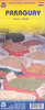

Paraguay
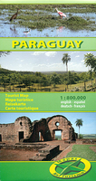
Paraguay at 1:800, 000 on an indexed, double-sided map from Mapas NaTurismo – German publishers specialising in coverage of Central and South America, with detailed presentation of the road network, national parks, etc.The map is double-sided, dividing the country north/south, with a generous overplay between the sides. Topography is presented by relief shading and altitude colouring, with spot heights and graphics indicating swamps, palm tree or papyrus groves and areas of yerba mate cultivation. National parks and other protected areas a prominently highlighted and the map also indicates important bird watching areas.Road network indicates dirt roads and includes seasonal tracks, showing distances on all roads and selected tracks, plus locations of fuel supplies and border
crossings. Railway lines are included and domestic airports are marked. Also shown are internal administrative boundaries with names of the provinces. A range of symbols highlight various places of interest including campsites, locations with hotels/lodges, churches of different religious orders, UNESCO World Heritage sites, horse riding facilities, etc. The map is indexed and has latitude and longitude lines at intervals of 30’. Map legend includes English.
crossings. Railway lines are included and domestic airports are marked. Also shown are internal administrative boundaries with names of the provinces. A range of symbols highlight various places of interest including campsites, locations with hotels/lodges, churches of different religious orders, UNESCO World Heritage sites, horse riding facilities, etc. The map is indexed and has latitude and longitude lines at intervals of 30’. Map legend includes English.

Product Description
Reviews/Comments
Add New
Vouchers
No voucher codes found.
Do you know a voucher code for this product or supplier? Add it to Insights for others to use.
Do you know a voucher code for this product or supplier? Add it to Insights for others to use.
 Denmark