
 United Kingdom
 France
 Germany
 Netherlands
 Sweden
 USA
USA
 Italy
Italy
 Spain
Spain
More From Contributor


Newark 1900
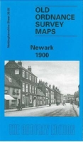
Newark in 1900 in a fascinating series of reproductions of old Ordnance Survey plans in the Alan Godfrey Editions, ideal for anyone interested in the history of their neighbourhood or family. Selected towns in Great Britain and Ireland are covered by maps showing the extent of urban development in the last decades of the 19th and early 20th century.In this title: the map covers the centre of Newark, and its southern and western outskirts. Coverage stretches from Queen's Road southward to Sconce Hills. Features include Market Place, St Mary's church, chapels, part of Midland Railway with southern end of station, Castle remains, Flour Mill with railway connection, River Trent, Hospital, Town Hall, chapels, schools, St Catherine's Well, Farndon Field, malthouse, Trent Bridge,
Town Wharf Grammar School, Chantry House, The Friary, Devon Bridge etc. On the reverse are street directory entries for Balderton Gate, Carter Gate, Castle Gate, Kirk Gate, Market Place, Middle Gate. About the Alan Godfrey Editions of the 25
Town Wharf Grammar School, Chantry House, The Friary, Devon Bridge etc. On the reverse are street directory entries for Balderton Gate, Carter Gate, Castle Gate, Kirk Gate, Market Place, Middle Gate. About the Alan Godfrey Editions of the 25
Product Description
Reviews/Comments
Add New
Intelligent Comparison
Archived Product
Newark 1900 Stanfords
£3.50
Archived Product

Newmarket 1901 Stanfords
£3.50
Archived Product
Newport 1900 Stanfords
£2.95
Archived Product

Newport 1900 Stanfords
£3.50
Archived Product
Newry 1903 Stanfords
£2.95
Vouchers
No voucher codes found.
Do you know a voucher code for this product or supplier? Add it to Insights for others to use.
Do you know a voucher code for this product or supplier? Add it to Insights for others to use.
 Denmark