
 United Kingdom
 France
 Germany
 Netherlands
 Sweden
 USA
USA
 Italy
Italy
 Spain
Spain
More From Contributor


Marrakech
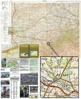
Marrakech at 1:5, 100 is an indexed tourist map with additional street and regional plans of other parts of the country. This map includes town centre plans of Essaouira and Agadir which show main routes through and around town, places of accommodation and tourist sites, as well as a larger, regional Moroccan map surrounding Marrakech at a scale of 1:500, 000.National, main, minor roads and tracks are shown, where applicable, on these maps, with mountainous sections and scenic routes particularly highlighted. Also indicated is the projected path of the motorway that is under construction form the North of the country to Agadir. Airports and airfields are shown.The central Marrakech map shows hotels, green spaces and places of interest to the visitor, mosques, parking facilities
and the railway station. Good windsurfing sites along the coast are marked on the broader area map, as well as selected places of interest outside of the capital and Kasbahs across the country. The publisher
and the railway station. Good windsurfing sites along the coast are marked on the broader area map, as well as selected places of interest outside of the capital and Kasbahs across the country. The publisher
Product Description
Reviews/Comments
Add New
Intelligent Comparison
Archived Product
Marrakech Stanfords
£10.00
Archived Product
Top 10 Marrakech Stanfords
£8.99
Vouchers
No voucher codes found.
Do you know a voucher code for this product or supplier? Add it to Insights for others to use.
Do you know a voucher code for this product or supplier? Add it to Insights for others to use.
 Denmark