More From Contributor
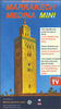
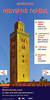
£2.95
Marple Rose Hill in 1896 in a fascinating series of reproductions of old Ordnance Survey plans in the Alan Godfrey Editions, ideal for anyone interested in the history of their neighbourhood or family. Selected towns in Great Britain & Ireland are covered by maps showing the extent of urban development in the last decades of the 19th & early 20th century. About the Alan Godfrey Editions of the 25 ...
Archived Product
£3.50
Marple Rose Hill in 1896 in a fascinating series of reproductions of old Ordnance Survey plans in the Alan Godfrey Editions, ideal for anyone interested in the history of their neighbourhood or family. About the Alan Godfrey Editions of the 25” OS Series: Selected towns in Great Britain & Ireland are covered by maps showing the extent of urban development in the last decades of the 19th & early 20th century. The plans have been taken from the Ordnance Survey mapping & reprinted at about 15 inches to one mile (1:4, 340). On the reverse most maps have historical notes & many also include extracts from contemporary directories. Most maps cover about one mile (1.6kms) north/south, one & a half miles (2.4kms) across; adjoining sheets can be combined to provide wider coverage.FOR MORE INFORMATION & A COMPLETE LIST OF ALL AVAILABLE TITLES PLEASE CLICK ON THE SERIES LINK. ...
Archived Product
£35.00
MARPOL Annex VI, Regulations for the prevention of air pollution from ships, covers the requirements in respect of both emissions to air (chapter 3) & energy efficiency (chapter 4). The requirements for control of nitrogen oxides (NOx), given by chapter 3, are supplemented by the mandatory NOx Technical Code 2008 which covers the testing, survey & certification of marine diesel engines. This fourth edition of the consolidated texts of MARPOL Annex VI & the NOx Technical Code 2008

Includes::
all amendments through to that adopted at MEPC 70 in October 2016. Also contained are the current versions of the Guidelines & other information relevant to the application of MARPOL Annex VI & the NOx Technical Code 2008. These include all those related to:• exhaust gas cleaning systems;• the energy efficiency aspects of chapter 4; and• selective catalytic reduction systems. This publication is intended to be of use to maritime administrations, recognized organizations, shipping companies, classification societies, educational institutes, shipbuilders & equipment manufacturers together with others with an interest in the prevention of air pollution from ships & in the technical & operational measures to improve the energy efficiency of ships.

...
Archived Product
£80.00
The International Convention for the Prevention of Pollution from Ships, 1973 (MARPOL Convention), is concerned with preserving the marine environment through the prevention of pollution by oil & other harmful substances & the minimization of accidental discharge of such substances. Its technical content is laid out in six Annexes, the first five of which were adopted by the 1973 Convention, as modified by a 1978 Protocol. These Annexes cover pollution of the sea by oil, by noxious liquid substances in bulk, by harmful substances in packaged form, by sewage from ships, & by garbage from ships. Annex VI was adopted by a further Protocol in 1997 & covers air pollution from ships. The 2017 consolidated edition aims to provide an easy & comprehensive reference to the up-to-date provisions & Unified Interpretations of the Articles, Protocols & Annexes of the MARPOL Convention, including the incorporation of all the amendments that have been adopted by the Marine Environment Protection Committee (MEPC). ...
Archived Product
£4.99
Marrakech at 1:5, 100 is an indexed tourist map with additional street & regional plans of other parts of the country. This map


...
Archived Product
£13.99
Marrakech
- High Atlas & Essaouira in the Thematic Destinations series from Footprint; exploring a range of varied worldwide destinations,
...
Archived Product
£5.99
The Medina of Marrakesh, the city’s historic heart, on a handy size, well-presented & very detailed, double-sided street plan from Medinacarte with a wealth of tourist information, including locations of main hotels, individual souks annotated to show what types of goods are sold there, etc. Unlike other maps of Marrakesh, this plan names not only the main streets within the Medina but also smaller ones, including over 400 derb passages. Colouring differentiates between buildings of traditional or modern architecture, indicates public parks or gardens, street markets, etc. Symbols mark various facilities: main hotels, cafes & restaurants, banks, ranks for taxis or horse drawn carriages, public phones & internet cafes, medical help, etc. The route of the cross-Medina bus line is shown with stops. Streets with souks & markets are highlighted, indicating what goods are sold there & where appropriate, doors which are locked at night. The plan is accompanied by an index of streets & derbs, a list of main hotels marked on it, plus a list of GPS coordinates for 36 important buildings & locations within the area. On the back cover of the map there are two at-a-glance plans highlighting locations of main points of interest & of the Medina’s gates & districts. The twelve main points of interest are pictured, with brief description, opening hours & position on the map. Map legend & accompanying text are in French & English. Whilst the main map covers the Medina area of Marrakesh, accompanying insert shows mains streets in the centre of Gueliz
- the new town, indicating selected facilities.PLEASE NOTE. Medinacarte also publish a larger size street plan of the Medina, which in addition shows locations of over 600 hotels & guesthouses.
...
Archived Product
£9.99
The Medina of Marrakesh, the city’s historic heart, on a large, well-presented & very detailed street plan from Medinacarte with a wealth of tourist information, including locations of over 600 hotels & guesthouses, individual souks annotated to show what types of goods are sold there, etc. Unlike other maps of Marrakesh, this plan names not only the main streets within the Medina but also smaller ones, including over 400 derb passages. Colouring differentiates between buildings of traditional or modern architecture, indicates public parks or gardens, street markets, etc. Symbols mark various facilities: over 600 hotels & guesthouses, cafes & restaurants, banks, ranks for taxis or horse drawn carriages, public phones & internet cafes, medical help, etc. The route of the cross-Medina bus line is shown with stops. Streets with souks & markets are highlighted, indicating what goods are sold there & where appropriate, doors which are locked at night. The plan is accompanied by an index of streets & derbs, a list of hotels & guesthouses marked on it, plus a list of GPS coordinates for 36 important buildings & locations within the area. On the back cover of the map there are two at-a-glance plans highlighting locations of main points of interest & of the Medina’s gates & districts. Map legend & accompanying text are in French & English.PLEASE NOTE: this map covers just the Medina area of Marrakesh, the rest of the city is not included. Medinacarte also publish a pocket, double-sided Mini Map of the Medina
- handy size, but with less information than presented in this version.
...
Archived Product
£6.99
Marrakech in the City Pack series from AA Publishing; covering an extensive selection of world-wide cities in a handy, pocket-sized laminated format. The guides provde a detailed overview of each destination, with each city organised by district to allow for practical use on the city streets. An introductory section introduces readers to the city, with individual features on a short stay in the city, the Top 25 attractions, shopping by theme, the city by night, eating out & restaurants by cuisine. Each guide is presented in a similar format, exploring the city by geographical area & district. A basic overview map is provided at the start of each section & there is detailed listings information on the principal sights, walks, shops, entertainment & nightlife & restaurants for each area of the city. A Farther Afield section explores the area outside the city limits, with suggestions for possible excursions & day trips. A dedicated accommodation chapter provides information about a range of budget, mid-range & luxury hotels to suit for individual tastes. There is also a Need to Know chapter with practical information on getting there & around, essential facts, language & a timeline of the city. ...
Archived Product
£8.99
Marrakech in the Frommer's Day By Day series is a pocket-sized guide ideal for short trips, covering a variety of budgets. The best sights of each destination are listed in convenient full-day tours for one, two or three days such as: thematic tours for interests including art, architecture & history are described, allowing you to get the most out of your time; walking tours take you around each destination ...
Archived Product

Marrakech

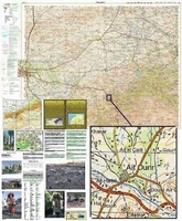
Marrakech and the region to the east of it extending to Demnat in a series of GPS compatible maps at 1:160, 000 published by EWP and West Col Productions and covering Morocco’s Atlas Mountains with its neighbouring deserts and coastal areas. The maps use the cartography of the Russian military survey of the area, providing a very detailed representation of the terrain, with contours at 40m intervals plus graphics and/or colouring to show features such as cliffs, ravines, sand ridges and dunes, various types of vegetation, etc. All place names are given in the Latin alphabet.Road information includes unsurfaced roads and tracks. Where main roads meet the edge of the map, the distance to the next large town is stated. Selected high passes are annotated to show months when passable.
Railways and local airports are marked and a range of symbols indicate various landmarks and places of interest, including mountain refuges and forestry buildings, oasis, caves, etc. Interesting locations are highlighted.Each sheet covers 40’ of latitude and 1° of longitude and has a grid based on the Kronstadt system which, according to the publishers’ notes, is related closely to the UTM system and is suitable for a GPS set to UTM or MGRS. The maps also have either additional margin ticks or a grid for latitude and longitude.On the reverse are illustrated notes about the area, plus a glossary of Berber terms and notes on transliteration of local names.Map legend and all the texts are in English and French.
RIP - This product is no longer available on our network. It was last seen on 25.09.2019

This page now acts as a permanent archive for this product. Add more information using the comments box below to ensure it can still be found by future generations.

Use our search facility to see if it is available from an alternative contributor.
  • Availability: Out Of Stock
  • Supplier: Stanfords
  • SKU: 9780906227978
Availability: In Stock
£10.00

Product Description

Marrakech & the region to the east of it extending to Demnat in a series of GPS compatible maps at 1:160, 000 published by EWP & West Col Productions & covering Morocco’s Atlas Mountains with its neighbouring deserts & coastal areas. The maps use the cartography of the Russian military survey of the area, providing a very detailed representation of the terrain, with contours at 40m intervals plus graphics and/or colouring to show features such as cliffs, ravines, sand ridges & dunes, various types of vegetation, etc. All place names are given in the Latin alphabet. Road information

Includes::
unsurfaced roads & tracks. Where main roads meet the edge of the map, the distance to the next large town is stated. Selected high passes are annotated to show months when passable. Railways & local airports are marked & a range of symbols indicate various landmarks & places of interest, including mountain refuges & forestry buildings, oasis, caves, etc. Interesting locations are highlighted. Each sheet covers 40’ of latitude & 1° of longitude & has a grid based on the Kronstadt system which, according to the publishers’ notes, is related closely to the UTM system & is suitable for a GPS set to UTM or MGRS. The maps also have either additional margin ticks or a grid for latitude & longitude. On the reverse are illustrated notes about the area, plus a glossary of Berber terms & notes on transliteration of local names. Map legend & all the texts are in English & French.

Reviews/Comments

Add New

Intelligent Comparison

Oooops!
We couldn't find anything!
Perhaps this product's unique.... Or perhaps we are still looking for comparisons!
Click to bump this page and we'll hurry up.

Price History

Vouchers

No voucher codes found.
Do you know a voucher code for this product or supplier? Add it to Insights for others to use.

Facebook

Jargon Buster

GPS - Global Positioning System - Global position using satellites
Graphics - A general term for visual aspects of an item/display
Railways - A set of tracks that have been laid for the purpose of trains to travel up and down them
edge - Enhanced data rates for GSM evolution also known as enhanced GPRS. A mobile phone technology with improved data transmission rates.
edge - The point at which two surfaces meet
Set - a group of items usually related to one another. Some objects cannot function without the complete set of items.
Large - something that takes up more space than normal.
Road - a manmade lane or a path that is used to speed up travel.

Supplier Information

Stanfords
Stanfords was established in 1853 and opened their iconic Covent Garden flagship store in 1901. They have become the top retailer of maps, travel books and accessories in the UK and arguably offer the largest selection of maps and travel books worldwide. Famous names such as Captain Robert Falcon Scott, Ranulph Fiennes and Michael Palin have purchased from Stanfords. They now have a shop in Bristol and both stores together with other venues operate a calendar of events including talks, book signings and exhibitions. As a specialist map retailer, the map selection is comprehensive and includes road maps, street maps and walking maps from worldwide destinations, as well as a selection of world atlases and wall maps. Books include travel guides and travel literature. Stanfords also stock globes, from miniatures made of blue marble to magnificent floor-standing globes. The website features a selection of interesting articles on travel topics.
Page Updated: 2023-11-12 20:15:36

Community Generated Product Tags

Oh No! The productWIKI community hasn't generated any tags for this product yet!
Menu