
 United Kingdom
 France
 Germany
 Netherlands
 Sweden
 USA
USA
 Italy
Italy
 Spain
Spain
More From Contributor


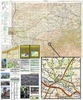
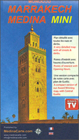
Marrakech - Medina Mini Map
The Medina of Marrakesh, the city’s historic heart, on a handy size, well-presented and very detailed, double-sided street plan from Medinacarte with a wealth of tourist information, including locations of main hotels, individual souks annotated to show what types of goods are sold there, etc.Unlike other maps of Marrakesh, this plan names not only the main streets within the Medina but also smaller ones, including over 400 derb passages. Colouring differentiates between buildings of traditional or modern architecture, indicates public parks or gardens, street markets, etc. Symbols mark various facilities: main hotels, cafes and restaurants, banks, ranks for taxis or horse drawn carriages, public phones and internet cafes, medical help, etc. The route of the
cross-Medina bus line is shown with stops. Streets with souks and markets are highlighted, indicating what goods are sold there and where appropriate, doors which are locked at night.The plan is accompanied by an index of streets and derbs, a list of main hotels marked on it, plus a list of GPS coordinates for 36 important buildings and locations within the area. On the back cover of the map there are two at-a-glance plans highlighting locations of main points of interest and of the Medina’s gates and districts. The twelve main points of interest are pictured, with brief description, opening hours and position on the map. Map legend and accompanying text are in French and English.Whilst the main map covers the Medina area of Marrakesh, accompanying insert shows mains streets in
the centre of Gueliz - the new town, indicating selected facilities.PLEASE NOTE. Medinacarte also publish a larger size street plan of the Medina, which additionally shows locations of over 600 hotels and guesthouses.

Product Description
Reviews/Comments
Add New
Vouchers
No voucher codes found.
Do you know a voucher code for this product or supplier? Add it to Insights for others to use.
Do you know a voucher code for this product or supplier? Add it to Insights for others to use.
 Denmark