More From Contributor

£9.99
Map No. 128, Maroon Bells
- Redstone
- Marble, CO, in an extensive series of GPS compatible, contoured hiking maps of USA’s

...
Archived Product
£2.95
Marple in 1896 in a fascinating series of reproductions of old Ordnance Survey plans in the Alan Godfrey Editions, ideal for anyone interested in the history of their neighbourhood or family. Selected towns in Great Britain & Ireland are covered by maps showing the extent of urban development in the last decades of the 19th & early 20th century. In this title: the map covers most of the village of Marple, a few miles south-east of Stockport. Coverage

Includes::
the village centre with Hollins Mill, Hollins House, old shafts, Mineral Mill, lime works, Macclesfield Canal, Marple Locks. The eastern half of the map, east of the river, is in Derbyshire. Coverage extends north to Lower Marple, where features include railway with station, spindle manufactory, St Martin's church, Marple Bridge. Further east are Bottom's Hall, Mellor Mill, Cataract Bridge, Clough Mill, Townscliff. On the reverse is the directory of Marple Bridge (which is rather small!) & extracts from a Cheshire Trade Directory for the region About the Alan Godfrey Editions of the 25

...
Archived Product
£3.50
Marple in 1896 in a fascinating series of reproductions of old Ordnance Survey plans in the Alan Godfrey Editions, ideal for anyone interested in the history of their neighbourhood or family. The map covers most of the village of Marple, a few miles south-east of Stockport. Coverage

Includes::
the village centre with Hollins Mill, Hollins House, old shafts, Mineral Mill, lime works, Macclesfield Canal, Marple Locks. The eastern half of the map, east of the river, is in Derbyshire. Coverage extends north to Lower Marple, where features include railway with station, spindle manufactory, St Martin`s church & Marple Bridge. Further east are Bottom`s Hall, Mellor Mill, Cataract Bridge, Clough Mill & Townscliff. On the reverse is the directory of Marple Bridge & extracts from a Cheshire Trade Directory for the region About the Alan Godfrey Editions of the 25” OS Series: Selected towns in Great Britain & Ireland are covered by maps showing the extent of urban development in the last decades of the 19th & early 20th century. The plans have been taken from the Ordnance Survey mapping & reprinted at about 15 inches to one mile (1:4, 340). On the reverse most maps have historical notes & many also include extracts from contemporary directories. Most maps cover about one mile (1.6kms) north/south, one & a half miles (2.4kms) across; adjoining sheets can be combined to provide wider coverage.FOR MORE INFORMATION & A COMPLETE LIST OF ALL AVAILABLE TITLES PLEASE CLICK ON THE SERIES LINK.

...
Archived Product
£2.95
Marple Rose Hill in 1896 in a fascinating series of reproductions of old Ordnance Survey plans in the Alan Godfrey Editions, ideal for anyone interested in the history of their neighbourhood or family. Selected towns in Great Britain & Ireland are covered by maps showing the extent of urban development in the last decades of the 19th & early 20th century. About the Alan Godfrey Editions of the 25 ...
Archived Product
£3.50
Marple Rose Hill in 1896 in a fascinating series of reproductions of old Ordnance Survey plans in the Alan Godfrey Editions, ideal for anyone interested in the history of their neighbourhood or family. About the Alan Godfrey Editions of the 25” OS Series: Selected towns in Great Britain & Ireland are covered by maps showing the extent of urban development in the last decades of the 19th & early 20th century. The plans have been taken from the Ordnance Survey mapping & reprinted at about 15 inches to one mile (1:4, 340). On the reverse most maps have historical notes & many also include extracts from contemporary directories. Most maps cover about one mile (1.6kms) north/south, one & a half miles (2.4kms) across; adjoining sheets can be combined to provide wider coverage.FOR MORE INFORMATION & A COMPLETE LIST OF ALL AVAILABLE TITLES PLEASE CLICK ON THE SERIES LINK. ...
Archived Product
£80.00
The International Convention for the Prevention of Pollution from Ships, 1973 (MARPOL Convention), is concerned with preserving the marine environment through the prevention of pollution by oil & other harmful substances & the minimization of accidental discharge of such substances. Its technical content is laid out in six Annexes, the first five of which were adopted by the 1973 Convention, as modified by a 1978 Protocol. These Annexes cover pollution of the sea by oil, by noxious liquid substances in bulk, by harmful substances in packaged form, by sewage from ships, & by garbage from ships. Annex VI was adopted by a further Protocol in 1997 & covers air pollution from ships. The 2017 consolidated edition aims to provide an easy & comprehensive reference to the up-to-date provisions & Unified Interpretations of the Articles, Protocols & Annexes of the MARPOL Convention, including the incorporation of all the amendments that have been adopted by the Marine Environment Protection Committee (MEPC). ...
Archived Product
£4.99
Marrakech at 1:5, 100 is an indexed tourist map with additional street & regional plans of other parts of the country. This map


...
Archived Product
£10.00
Marrakech & the region to the east of it extending to Demnat in a series of GPS compatible maps at 1:160, 000 published by EWP & West Col Productions & covering Morocco’s Atlas Mountains with its neighbouring deserts & coastal areas. The maps use the cartography of the Russian military survey of the area, providing a very detailed representation of the terrain, with contours at 40m intervals plus graphics and/or colouring to show features such as cliffs, ravines, sand ridges & dunes, various types of vegetation, etc. All place names are given in the Latin alphabet. Road information

Includes::
unsurfaced roads & tracks. Where main roads meet the edge of the map, the distance to the next large town is stated. Selected high passes are annotated to show months when passable. Railways & local airports are marked & a range of symbols indicate various landmarks & places of interest, including mountain refuges & forestry buildings, oasis, caves, etc. Interesting locations are highlighted. Each sheet covers 40’ of latitude & 1° of longitude & has a grid based on the Kronstadt system which, according to the publishers’ notes, is related closely to the UTM system & is suitable for a GPS set to UTM or MGRS. The maps also have either additional margin ticks or a grid for latitude & longitude. On the reverse are illustrated notes about the area, plus a glossary of Berber terms & notes on transliteration of local names. Map legend & all the texts are in English & French.

...
Archived Product
£13.99
Marrakech
- High Atlas & Essaouira in the Thematic Destinations series from Footprint; exploring a range of varied worldwide destinations,
...
Archived Product
£5.99
The Medina of Marrakesh, the city’s historic heart, on a handy size, well-presented & very detailed, double-sided street plan from Medinacarte with a wealth of tourist information, including locations of main hotels, individual souks annotated to show what types of goods are sold there, etc. Unlike other maps of Marrakesh, this plan names not only the main streets within the Medina but also smaller ones, including over 400 derb passages. Colouring differentiates between buildings of traditional or modern architecture, indicates public parks or gardens, street markets, etc. Symbols mark various facilities: main hotels, cafes & restaurants, banks, ranks for taxis or horse drawn carriages, public phones & internet cafes, medical help, etc. The route of the cross-Medina bus line is shown with stops. Streets with souks & markets are highlighted, indicating what goods are sold there & where appropriate, doors which are locked at night. The plan is accompanied by an index of streets & derbs, a list of main hotels marked on it, plus a list of GPS coordinates for 36 important buildings & locations within the area. On the back cover of the map there are two at-a-glance plans highlighting locations of main points of interest & of the Medina’s gates & districts. The twelve main points of interest are pictured, with brief description, opening hours & position on the map. Map legend & accompanying text are in French & English. Whilst the main map covers the Medina area of Marrakesh, accompanying insert shows mains streets in the centre of Gueliz
- the new town, indicating selected facilities.PLEASE NOTE. Medinacarte also publish a larger size street plan of the Medina, which in addition shows locations of over 600 hotels & guesthouses.
...
Archived Product

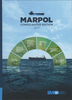
MARPOL Annex VI And NTC 2008, 2017 Edition

MARPOL Annex VI, Regulations for the prevention of air pollution from ships, covers the requirements in respect of both emissions to air (chapter 3) and energy efficiency (chapter 4). The requirements for control of nitrogen oxides (NOx), given by chapter 3, are supplemented by the mandatory NOx Technical Code 2008 which covers the testing, survey and certification of marine diesel engines.This fourth edition of the consolidated texts of MARPOL Annex VI and the NOx Technical Code 2008 includes all amendments through to that adopted at MEPC 70 in October 2016.Also contained are the current versions of the Guidelines and other information relevant to the application of MARPOL Annex VI and the NOx Technical Code 2008.These include all those related to:• exhaust gas cleaning systems;•
the energy efficiency aspects of chapter 4; and• selective catalytic reduction systems.This publication is intended to be of use to maritime administrations, recognized organizations, shipping companies, classification societies, educational institutes, shipbuilders and equipment manufacturers together with others with an interest in the prevention of air pollution from ships and in the technical and operational measures to improve the energy efficiency of ships.
RIP - This product is no longer available on our network. It was last seen on 25.09.2019

This page now acts as a permanent archive for this product. Add more information using the comments box below to ensure it can still be found by future generations.

Use our search facility to see if it is available from an alternative contributor.
  • Availability: Out Of Stock
  • Supplier: Stanfords
  • SKU: 9789280116588
Availability: In Stock
£35.00

Product Description

MARPOL Annex VI, Regulations for the prevention of air pollution from ships, covers the requirements in respect of both emissions to air (chapter 3) & energy efficiency (chapter 4). The requirements for control of nitrogen oxides (NOx), given by chapter 3, are supplemented by the mandatory NOx Technical Code 2008 which covers the testing, survey & certification of marine diesel engines. This fourth edition of the consolidated texts of MARPOL Annex VI & the NOx Technical Code 2008

Includes::
all amendments through to that adopted at MEPC 70 in October 2016. Also contained are the current versions of the Guidelines & other information relevant to the application of MARPOL Annex VI & the NOx Technical Code 2008. These include all those related to:• exhaust gas cleaning systems;• the energy efficiency aspects of chapter 4; and• selective catalytic reduction systems. This publication is intended to be of use to maritime administrations, recognized organizations, shipping companies, classification societies, educational institutes, shipbuilders & equipment manufacturers together with others with an interest in the prevention of air pollution from ships & in the technical & operational measures to improve the energy efficiency of ships.

Reviews/Comments

Add New

Intelligent Comparison

Oooops!
We couldn't find anything!
Perhaps this product's unique.... Or perhaps we are still looking for comparisons!
Click to bump this page and we'll hurry up.

Price History

Vouchers

No voucher codes found.
Do you know a voucher code for this product or supplier? Add it to Insights for others to use.

Facebook

Jargon Buster

Diesel - A fuel used in internal combustion engines
Diesel - An Italian clothing brand. Founded in 1978
Equipment - A product or good that is tactile.
technical - Something that relates to a good level of skill and methods.

Supplier Information

Stanfords
Stanfords was established in 1853 and opened their iconic Covent Garden flagship store in 1901. They have become the top retailer of maps, travel books and accessories in the UK and arguably offer the largest selection of maps and travel books worldwide. Famous names such as Captain Robert Falcon Scott, Ranulph Fiennes and Michael Palin have purchased from Stanfords. They now have a shop in Bristol and both stores together with other venues operate a calendar of events including talks, book signings and exhibitions. As a specialist map retailer, the map selection is comprehensive and includes road maps, street maps and walking maps from worldwide destinations, as well as a selection of world atlases and wall maps. Books include travel guides and travel literature. Stanfords also stock globes, from miniatures made of blue marble to magnificent floor-standing globes. The website features a selection of interesting articles on travel topics.
Page Updated: 2023-11-12 20:15:36

Community Generated Product Tags

Oh No! The productWIKI community hasn't generated any tags for this product yet!
Menu