
 United Kingdom
 France
 Germany
 Netherlands
 Sweden
 USA
USA
 Italy
Italy
 Spain
Spain
More From Contributor


Malaysia Reise Know-How
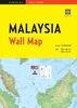
Malaysia at 1:800, 000 for the peninsular part of the country and at 1:1, 100, 000 for Sarawak and Sabah (Northern Borneo) on an indexed road map with topographic and tourist information, printed on light, waterproof and tear-resistant plastic paper. The map, part of Reise Know-How’s highly acclaimed World Mapping Project, is double-sided to provide the best balance between a good scale and a convenient size sheet.On one side is the Peninsular Malaysia shown at 1:800, 000, with on the reverse the country’s two provinces on northern Borneo, Sarawak and Sabah, and Brunei. Topography is indicated by altitude colouring with spot heights, names of mountain ranges and peaks, swamps, mangroves and coral reefs in the coastal waters. National parks and other protected areas are
highlighted. Road network includes local roads and selected tracks. Intermediate driving distances are shown on main routes. Railway lines and ferry connections are included and local airports or airfields are marked. Also indicated are internal administrative boundaries with names of the provinces. Symbols highlight various places of interest, including mosques and Hindu or Buddhist temples, caves, beaches and diving sites, etc. Latitude and longitude lines are drawn at12° intervals and the map has an extensive index of localities. Map legend includes English.
highlighted. Road network includes local roads and selected tracks. Intermediate driving distances are shown on main routes. Railway lines and ferry connections are included and local airports or airfields are marked. Also indicated are internal administrative boundaries with names of the provinces. Symbols highlight various places of interest, including mosques and Hindu or Buddhist temples, caves, beaches and diving sites, etc. Latitude and longitude lines are drawn at12° intervals and the map has an extensive index of localities. Map legend includes English.

Product Description
Reviews/Comments
Add New
Vouchers
No voucher codes found.
Do you know a voucher code for this product or supplier? Add it to Insights for others to use.
Do you know a voucher code for this product or supplier? Add it to Insights for others to use.
 Denmark