More From Contributor

£6.99
Malaysia on a double-sided map by Periplus, with enlargements for its most visited regions plus street plans for central Kuala Lumpur, Melaka, Georgetown, Johor Bahru, Kota Kinabalu & Kuching. Peninsular Malaysia is shown at 1:1, 500, 000, with Sabah & Sarawak at 1:2, 000, 000, accompanied by a map showing these two parts of the country in proper geographical context at 1:6, 500, 000. The network of main roads & railways is shown on a base with bold relief shading & spot heights for the main peaks. Local airports are marked & numerous places of interest highlighted, including historic sites, beaches, diving sites & national parks. The mapping also shows internal administrative divisions with names of the provinces. Latitude & longitude lines are drawn at intervals of 2° on the main country maps. The map also
Includes::* Enlargements of the Johor Bahru region with Singapore (1:200, 000) & of the Penang Island (1:80, 000)* Greater Kuala Lumpur area at 1:230, 000 plus a large street plan of central Kuala Lumpur at 1:15, 000* Street plans of central Georgetown (1:15, 000), Melaka (1:15, 000), Johor Bahru (1:20, 000), Kuching (1:17, 500) & Kota Kinabalu (1:30, 000). Like the main maps & the enlargements, street plans are also all annotated with various places of interest, plus numerous hotels, etc. None of the maps or plans are indexed. Also provided is a distance table.
...
Archived Product
£4.99
Malaysia in the Pocket Guide series from Berlitz; a collection of handy, pocket-sized guides dedicated to an extensive range of cities, regions & countries worldwide. Written in narrative form, individual guides explore the history, main sights & attractions, food & drink, accommodation & local culture of the destination in detail. Each Berlitz pocket guide has a similar format, with colour-coded sections helping readers locate information quickly in addition to distinctive chapters exploring the city or region. An introduction outlines the destination for visitors & a section dedicated to 'A Brief History' actually explores the area in relative depth. A where to go chapter is organized by region & city & is written in prose form with references to individual sites highlighted in bold for clarity. There are also further suggestions on where & when to eat. Recommendations for leisure activities in the region, including sport, nightlife & shopping, are also provided & tailored accordingly for each destination. Handy travel tips are listed alphabetically in a dedicated section, providing practical guidance & helping visitors make the most of their stay. The main hotels, particularly for cities, are also listed in an accommodation section, offering a brief overview with approximate price bandings & relevant contact details. ...
Archived Product
£6.99
Berlitz Pocket Guide Malaysia is a concise, full-colour travel guide that combines lively text with vivid photography to highlight the very best that this diverse country has to offer. The Where To Go chapter details all the key sights on a tour of both Peninsular Malaysia & Malaysia Borneo, from the dazzling architecture of Kuala Lumpur & the World Heritage Sites of Georgetown & Melaka, to the natural splendours of Mount Kinabalu & the world`s largest orangutan sanctuary in Sabah. Handy maps on the cover help you to get around with ease. To inspire you, the book offers a rundown of the Top 10 Attractions in Malaysia, followed by an itinerary for a Perfect Tour of the country. The What to Do chapter is a snapshot of ways to spend your spare time, from shopping & sports to traditonal Malay dance & theatre. You`ll also be armed with background information, including a brief history of the country & an Eating Outchapter covering its mouth-watering cuisine. There are carefully chosen listings of the best hotels & restaurants, & an A-Z to give you all the practical information you will need Malaysia`s diverse wildlife, tropical beaches & dynamic capital city of Kuala Lumpur are attracting more & more visitors each year, with a record number of 24.7 million tourists in 2011 (Tourism Malaysia). Berlitz Pocket Guide Malaysia is the ideal handy guide to this diverse & fascinating country, combining concise information on where to go & what to do with great photography & full-colour, fold-out maps. ...
Archived Product
£6.99
Berlitz Pocket Guide Malaysia is a concise, full-colour travel guide that combines lively text with vivid photography to highlight the very best that this diverse country has to offer. The Where To Go chapter details all the key sights on a tour of both Peninsular Malaysia & Malaysia Borneo, from the dazzling architecture of Kuala Lumpur & the World Heritage Sites of Georgetown & Melaka, to the natural splendours of Mount Kinabalu & the world's largest orangutan sanctuary in Sabah. Handy maps on the cover help you to get around with ease. To inspire you, the book offers a rundown of the Top 10 Attractions in Malaysia, followed by an itinerary for a Perfect Tour of the country. The What to Do chapter is a snapshot of ways to spend your spare time, from shopping & sports to traditonal Malay dance & theatre. You'll also be armed with background information, including a brief history of the country & an Eating Out chapter covering its mouth-watering cuisine. There are carefully chosen listings of the best hotels & restaurants, & an A-Z to give you all the practical information you will need. ...
Archived Product
£11.50
Malaysia at 1:800, 000 for the peninsular part of the country & at 1:1, 100, 000 for Sarawak & Sabah (Northern Borneo) on an indexed road map with topographic & tourist information, printed on light, waterproof & tear-resistant plastic paper. The map, part of Reise Know-How’s highly acclaimed World Mapping Project, is double-sided to provide the best balance between a good scale & a convenient size sheet. On one side is the Peninsular Malaysia shown at 1:800, 000, with on the reverse the country’s two provinces on northern Borneo, Sarawak & Sabah, & Brunei. Topography is indicated by altitude colouring with spot heights, names of mountain ranges & peaks, swamps, mangroves & coral reefs in the coastal waters. National parks & other protected areas are highlighted. Road network

Includes::
local roads & selected tracks. Intermediate driving distances are shown on main routes. Railway lines & ferry connections are included & local airports or airfields are marked. Also indicated are internal administrative boundaries with names of the provinces. Symbols highlight various places of interest, including mosques & Hindu or Buddhist temples, caves, beaches & diving sites, etc. Latitude & longitude lines are drawn at 12° intervals & the map has an extensive index of localities. Map legend

Includes::
English.


...
Archived Product
£7.95
Peninsular Malaysia at 1:1, 500, 000 & a street plan of Singapore at 1:15, 000 from Nelles Verlag, with a smaller size sheet offering a convenient format for use when travelling. Also included are several other street plans & enlargements. On one side is a road map of the western, peninsular part of Malaysia. Vivid relief shading, numerous spot & names of mountain ranges, plus graphics for marshlands present the topography. National parks & other protected area are marked. Road network distinguishes between highways in good & poor condition &

Includes::
partially paved roads & cart tracks, with distances shown on main routes. Railway lines & local airports are included, & the map also shows internal administrative boundaries with names of the states. Numerous places of interest are prominently marked. Latitude & longitude margin ticks are at 1

...
Archived Product
£10.99
Road map fro Nelles Verlag presenting the Peninsular Malaysia at 1:1, 500, 000 with additional street plans & enlargements, plus on the reverse an indexed street plan of Singapore City & maps of Singapore Island & an enlargement of Sentosa Isl&. Smaller size sheet offers a convenient format for use when travelling & map legend for all the sections of this title

Includes::
English. On one side is a road map of the western, peninsular part of Malaysia. Vivid relief shading, spot & names of mountain ranges, plus graphics for marshlands present the topography. National parks & other protected area are marked. Road network distinguishes between highways in good & poor condition &

Includes::
partially paved roads & cart tracks, with distances shown on main routes. Railway lines & local airports are included, & the map also shows internal administrative boundaries with names of the states. Numerous places of interest are prominently marked. Latitude & longitude margin ticks are at 1


...
Archived Product
£10.99
Road map fro Nelles Verlag presenting the Peninsular Malaysia at 1:1, 500, 000 with additional street plans & enlargements, plus on the reverse an indexed street plan of Singapore City & maps of Singapore Island & an enlargement of Sentosa Isl&. Smaller size sheet offers a convenient format for use when travelling & map legend for all the sections of this title

Includes::
English. On one side is a road map of the western, peninsular part of Malaysia. Vivid relief shading, spot & names of mountain ranges, plus graphics for marshlands present the topography. National parks & other protected area are marked. Road network distinguishes between highways in good & poor condition &

Includes::
partially paved roads & cart tracks, with distances shown on main routes. Railway lines & local airports are included, & the map also shows internal administrative boundaries with names of the states. Numerous places of interest are prominently marked. Latitude & longitude margin ticks are at 1° intervals. The map has no index of localities. The map is accompanied by enlargements showing in greater detail the Kuala Lumpur region, Penang & Pangkor, plus street plans highlighting main places of interest in central Kuala Lumpur, Georgetown & Melaka/ Malacca. On the reverse central Singapore is shown on a street plan at 1:15, 000, clearly indicating metro stations & showing public buildings & various places of interest. The plan is indexed for streets, housing & industrial estates, places of interest, hotels, embassies & medical centres. 64 institutions marked on the plan within the Business District are cross-referenced to a list of their names. Also included is a map of the whole Singapore Island at 1:125, 000 clearly showing railway connections, plus an enlargement of the Sentosa Island at 1:22, 500.


...
Archived Product
£5.99
Malaysia Indonesia & the Philippines at 1:4, 000, 000 on a large indexed map from Insight Guides, with street plans of central Bangkok, Kuala Lumpur & Singapore, plus both central & Old Jakarta, all also indexed. The map provides much wider coverage than suggested by its title &

Includes::
the whole of South East Asia (Thail&, Cambodia, Laos & Vietnam), plus most of Burma/ Myanmar. The base map uses hill-shading to portray the relief; heights of significant peaks are indicated & many rivers, lakes & highland ranges are named. Communication detail

Includes::
major railways, ferry routes & airports, & intermediate driving distances are indicated on main roads. No distinction is made between surfaced & unsurfaced main roads, although some minor routes are classed as tracks. Where main roads meet the edge of the map the distance to next major location is stated. National parks & reserves are marked, & coloured symbols highlight selected sites of interest. Latitude & longitude lines are drawn at 2


...
Archived Product
£16.99
Malaysia, Singapore & Brunei in the Countries, Regions & Cities series from Rough Guides; comprehensively detailed guidebooks specifically designed for independent travellers & serving a range of worldwide destinations. Widely recognised for their free editorial style, Rough Guide authors are allowed to express their personal opinions on a range of subjects. Although sometimes controversial, this editorial stance allows readers to experience more detailed & personal takes on each destination, a feature often more limited in other guidebooks. Cultural & historical nuances are explored in significant depth throughout the text & descriptions on the ambience of individual settings alongside personal recommendations, particularly in cities, are notably prevalent. Each Rough Guide in the Countries, Regions & Cities series has a similar layout. A ...
Archived Product

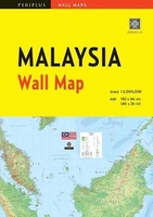
Malaysia Wall Map First Edition

This portable map of Malaysia guarantees you won`t go anywhere without the information you need!This first edition wall map of Malaysia is handsome enough to hang up and display, while sufficiently compact to carry on hand for easy access. It is scaled at 1:2, 000, 000 and features a simple-to-use legend for quick reference. When not in use, the map can be folded to a compact 7 1/2 x 10 3/4 inches, and stored in the included protective pocket with a cardstock cover. However, when opened, it hangs for easy display. This Malaysia map emphasizes essential points of interest such as: Transportation (airports, ferries, highways and secondary roads, etc.) Recreational amenities (beaches, museums, golf courses, etc.) Places of worship, educational facilities, lighthouses, and towers
Geographic features (ponds, rivers, lakes) and more!Never be caught off-guard with this thorough and up-to-date map and Malaysia atlas from Periplus, the number one publisher of maps for foreign travelers in Asia.
RIP - This product is no longer available on our network. It was last seen on 25.09.2019

This page now acts as a permanent archive for this product. Add more information using the comments box below to ensure it can still be found by future generations.

Use our search facility to see if it is available from an alternative contributor.
  • External links may include paid for promotion
  • Availability: Out Of Stock
  • Supplier: Stanfords
  • SKU: 9780794608088
Availability: In Stock
£4.99

Product Description

This portable map of Malaysia guarantees you won`t go anywhere without the information you need! This first edition wall map of Malaysia is handsome enough to hang up & display, while sufficiently compact to carry on hand for easy access. It is scaled at 1:2, 000, 000 & features a simple-to-use legend for quick reference. When not in use, the map can be folded to a compact 7 1/2 x 10 3/4 inches, & stored in the included protective pocket with a cardstock cover. However, when opened, it hangs for easy display. This Malaysia map emphasizes essential points of interest such as: Transportation (airports, ferries, highways & secondary roads, etc.) Recreational amenities (beaches, museums, golf courses, etc.) Places of worship, educational facilities, lighthouses, & towers Geographic features (ponds, rivers, lakes) & more! Never be caught off-guard with this thorough & up-to-date map & Malaysia atlas from Periplus, the number one publisher of maps for foreign travelers in Asia.

Reviews/Comments

Add New

Intelligent Comparison

Oooops!
We couldn't find anything!
Perhaps this product's unique.... Or perhaps we are still looking for comparisons!
Click to bump this page and we'll hurry up.

Price History

Vouchers

No voucher codes found.
Do you know a voucher code for this product or supplier? Add it to Insights for others to use.

Facebook

Jargon Buster

Hand - A part of the body at the end of the arm
Hand - A pointer which indicates time on a clock face
Date - A day on a calendar
Date - A social activity whith a current or potential partner
compact - Carefuly designed to ensure an item has a minimal physical size
Wall - A physical barrier between two areas
Quick - Something that is fast
Compact - something that has a lot combined within a small space.
Golf - A sport played on a large outside grass course, the aim to hit a small ball with a club into small holes.
Simple - Basic, easy no difficulty in understanding.
Pocket - A bag shaped insert in clothing used to carry items
Reference - To prove evidence with a back up source.

Supplier Information

Stanfords
Stanfords was established in 1853 and opened their iconic Covent Garden flagship store in 1901. They have become the top retailer of maps, travel books and accessories in the UK and arguably offer the largest selection of maps and travel books worldwide. Famous names such as Captain Robert Falcon Scott, Ranulph Fiennes and Michael Palin have purchased from Stanfords. They now have a shop in Bristol and both stores together with other venues operate a calendar of events including talks, book signings and exhibitions. As a specialist map retailer, the map selection is comprehensive and includes road maps, street maps and walking maps from worldwide destinations, as well as a selection of world atlases and wall maps. Books include travel guides and travel literature. Stanfords also stock globes, from miniatures made of blue marble to magnificent floor-standing globes. The website features a selection of interesting articles on travel topics.
Page Updated: 2023-11-12 20:15:36

Community Generated Product Tags

Oh No! The productWIKI community hasn't generated any tags for this product yet!
Menu