More From Contributor
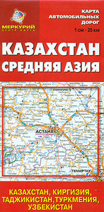
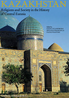
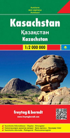
£24.95
Kayak Cevennes is a full bilingual kayaking guidebook (French & English text) which describes 44 rivers South-East of the French Massif Central
- 68 runs from grade 3 to 6. It

Includes::
well-known rivers such as ” Haut Tarn”, ” Dourbie”, ” Bourges”, as well as many unknown runs. 5 Freestyle playspots are also described. Rivers are introduced by well known paddlers: the ” Haut Tarn” by Jay Sigbrandt, the ” Drobie” by Paul Villecourt, the ” Glueyre” by Simon Leveque (Canada), the ” Beaume” by Jean Lamy, etcetera.


...
Archived Product
£9.99
Loel Collins draws on his experience to help the readers learn to roll a kayak or improve the roll they already have. The approach is to illustrate the ideas with clear photo sequences, keeping the text to a minimum. Rolling is learnt by working through a sequence of exercises to allow the learner to `feel` what is required. Once the initial sequences have been learnt, problems are identified & solved. The learners are then provided with exercises to prepare them for the challenges involved in rolling in rough water & given advice on how to cope when they get there. For those who wish to improve an unreliable roll, a flow chart helps them to plan a learning sequence & choose the appropriate exercises. Although aimed at kayakers, the book is also a mine of useful tools for the coach looking for tools that they can use when teaching rolling. ...
Archived Product
£8.99
Kayaking is a tremendously wide--ranging sport. You can go for a leisurely paddle on your local pond, travel down a river or experience the thrills of ehite water. It is truly a sport for life. This lavishly--illustrated, clearly--written guide will have you out on the water fast -- & in safety. It covers: * How to get started * The equipment youa ll need * Launching * how to control the boat * Basic manoeuvres * What to do if you capsize * The Eskimo roll * Rescue procedures. ...
Archived Product
£21.99
This is a modern illustrated `how to` guide to kayaking, with authoritative information for beginners as well as the experienced paddler, all delivered with humour & enthusiasm. Presented in colour with easy-to-follow, step-by-step photographic sequences & inspirational action images, this manual covers everything from flat water through to ocean paddling, white water & surfing. The book also explains the clothing & equipment required for every type of kayaking &, of course, the boats & paddles themselves, as well as weather, hydrodynamics, safety & rescue. ...
Archived Product
£17.99
The 1:50 000 topographic map gives a more general picture of the ground features than a basic map. It shows settlements, houses, roads, cultivated areas, waterways, cutting areas, mires, rock exposures, & relief. One map sheet covers an area of 30 x 40 km & one centimetre corresponds to 500 metres on the ground. The 1:50, 000 topographic map is also an ideal complement to nautical charts as it provides useful information about the land areas adjacent to waterways. For example, all Finnish sea areas are covered by 1:50 000 topographic map sheets. ...
Archived Product
£9.50
Indexed, waterproof & tear-resistant road map of Kazakhstan & the northern half of Kyrgyzstan with topographic & tourist information, published by Reise Know-How as part of their highly acclaimed World Mapping Project. The map is double-sided to provide the best balance between a good scale & a convenient size sheet. Road & rail networks are easy to see on a clear base which shows the area ...
Archived Product
£6.95
Kazakhstan at 1:2, 500, 000 on a double-sided map from the Russian publishers Merkury with English legend but all place names given in Cyrillic alphabet. Coverage extends south to include Uzbekistan Kyrgyzstan, Tajikistan & Turkmenistan. The map shows the countries’ road & rail networks on a plain white base with topography indicated by spot heights, but including seasonal rivers & lakes, salt flats & swamps. National parks & other protected areas are highl;ighted. Roads network shows distances on main & many secondary routes & indicates locations of railway stations & border crossings. Also indicated are internal administrative boundaries with names of the provinces. The map has no geographical coordinates. Also provided is a distance table with locations in all the five ex-Soviet Union countries & a political map of the area showing distances on main routes, as well as facts-&-figures panels for each country.A curious addition is a political map of Europe showing major road connections & membership of the European Union. ...
Archived Product
£52.50
This book is essentially a portfolio of the religious experience in the Kazakh lands organized in two parts: the first devoted to the religions of the Steppes of Central Eurasia (present-day Kazakhstan) in the prehistoric & ancient period, & the second is devoted to the study of the different religious beliefs professed by the various populations who lived & live in the Kazakh Steppes in the medieval, modern & contemporary periods (12th-20th century). Special attention is given to themes of the utmost importance such as Buddhist Lamaism in Kazakh lands, the role of religion in the control of intertribal conflicts between Kazakhs, & the Jewish presence in nineteenth & twentieth-century Kazakhstan. This book is illustrated with a wealth of photographs & maps of the major places of worship in Kazakhstan from archive collections belonging to Kazakhstan & the Russian Federation. ...
Archived Product
£9.99
Double-sided, indexed map presenting on one side Kazakhstan at 1:3, 000, 000 accompanied by street plans of Astana & Almaty, with on the reverse Uzbekistan at 1:1, 580, 000 with street plan of Tashkent & Samark&. Topography is shown by altitude colouring with spot heights & names of mountain ranges. The maps show the two countries’ road & railway networks, indicating the main routes of the Silk Road. Symbols highlight various places of interest. Latitude & longitude lines are drawn at 1º intervals & each side has a separate index. The four street plans indicate locations of various facilities & places of interest. ...
Archived Product
£9.99
Kazakhstan at 1:3, 000, 000 from Gizi Map with bold altitude colouring providing an excellent picture of the country’s topography, an index of localities on the reverse, & good coverage of the adjoining regions: the map extends well beyond Kazakhstan’s borders to include the other four Central Asian countries (Uzbekistan, Kyrgyzstan, Tajikistan & Turkmenistan), as well as part of western China, Pakistan north of Islamabad/ Rawalpindi/ Peshawar, the northern half of Afghanistan with Kabul, a large part of Iran with Teheran & Isfahan, the whole of the Caspian Sea, plus the border region of Russia from Volgograd to Novosibirsk. All place names are in the Latin alphabet. The map shows the region’s rail & road networks, including dirt tracks, & gives driving distances on major routes. Local airports are marked & the map shows names & boundaries of Kazakhstan’s administrative provinces. Vivid presentation of the topography through bold altitude colouring

Includes::
graphics for deserts, swamps & salt flats, with plenty of names of mountain ranges, peaks, etc. National parks are highlighted, as are the various routes of the Silk Road. Latitude & longitude lines are drawn at 2° intervals. The index, separate for each country covered by the map, is on the reverse. Map legend

Includes::
English.PLEASE NOTE: the same map but with slightly reduced coverage of western China is also available in a political edition where the altitude colouring has been replaced by a different colour for each country. The political version also

Includes::
a street plan of Astana. Both the geographical & the political versions are also available as wall maps.


...
Archived Product

Kazakhstan

Indexed, double-sided map of Kazakhstan printed on waterproof and tear-resistant paper, with plans of central Almaty and Astana. Topography is shown by altitude colouring with spot heights, indicating swamps and slat flats, seasonal rivers and lakes, deserts, etc. Around the Aral Sea the water level in 1960 is marked. The map shows the country
RIP - This product is no longer available on our network. It was last seen on 25.09.2019

This page now acts as a permanent archive for this product. Add more information using the comments box below to ensure it can still be found by future generations.

Use our search facility to see if it is available from an alternative contributor.
  • External links may include paid for promotion
  • Availability: Out Of Stock
  • Supplier: Stanfords
  • SKU: 9781553412694
Availability: In Stock
£9.95

Product Description

Indexed, double-sided map of Kazakhstan printed on waterproof & tear-resistant paper, with plans of central Almaty & Astana. Topography is shown by altitude colouring with spot heights, indicating swamps & slat flats, seasonal rivers & lakes, deserts, etc. Around the Aral Sea the water level in 1960 is marked. The map shows the country

Reviews/Comments

Add New

Price History

Vouchers

No voucher codes found.
Do you know a voucher code for this product or supplier? Add it to Insights for others to use.

Facebook

Jargon Buster

Paper - A thin sheet mainly used for writing. Available in a variety of colours. Made mainly from wood pulp.
water - A chemical substance. Chemical formula H2O.
Waterproof - Resistant to water, usualy specified by depth in metres
Resistant - Something that can repel against something.
Altitude - Something that can be quite high in relation to sea or ground level.

Supplier Information

Stanfords
Stanfords was established in 1853 and opened their iconic Covent Garden flagship store in 1901. They have become the top retailer of maps, travel books and accessories in the UK and arguably offer the largest selection of maps and travel books worldwide. Famous names such as Captain Robert Falcon Scott, Ranulph Fiennes and Michael Palin have purchased from Stanfords. They now have a shop in Bristol and both stores together with other venues operate a calendar of events including talks, book signings and exhibitions. As a specialist map retailer, the map selection is comprehensive and includes road maps, street maps and walking maps from worldwide destinations, as well as a selection of world atlases and wall maps. Books include travel guides and travel literature. Stanfords also stock globes, from miniatures made of blue marble to magnificent floor-standing globes. The website features a selection of interesting articles on travel topics.
Page Updated: 2023-11-12 20:15:36

Community Generated Product Tags

Oh No! The productWIKI community hasn't generated any tags for this product yet!
Menu