
 United Kingdom
 France
 Germany
 Netherlands
 Sweden
 USA
USA
 Italy
Italy
 Spain
Spain
More From Contributor


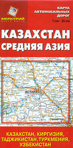
Kazakhstan
Kazakhstan at 1:2, 500, 000 on a double-sided map from the Russian publishers Merkury with English legend but all place names given in Cyrillic alphabet. Coverage extends south to include Uzbekistan Kyrgyzstan, Tajikistan and Turkmenistan.The map shows the countries’ road and rail networks on a plain white base with topography indicated by spot heights, but including seasonal rivers and lakes, salt flats and swamps. National parks and other protected areas are highl;ighted. Roads network shows distances on main and many secondary routes and indicates locations of railway stations and border crossings. Also indicated are internal administrative boundaries with names of the provinces. The map has no geographical coordinates. Also provided is a distance table with locations in all the
five ex-Soviet Union countries and a political map of the area showing distances on main routes, as well as facts-and-figures panels for each country.A curious addition is a political map of Europe showing major road connections and membership of the European Union.
five ex-Soviet Union countries and a political map of the area showing distances on main routes, as well as facts-and-figures panels for each country.A curious addition is a political map of Europe showing major road connections and membership of the European Union.

Product Description
Reviews/Comments
Add New
Intelligent Comparison
Archived Product
Kazakhstan Stanfords
£9.95
Archived Product

Kazakhstan Stanfords
£9.50
Archived Product
Kazakhstan Stanfords
£52.50
Archived Product
Kazakhstan F&B Stanfords
£10.99
Archived Product
Flag Of Kazakhstan Stanfords
£8.99
Vouchers
No voucher codes found.
Do you know a voucher code for this product or supplier? Add it to Insights for others to use.
Do you know a voucher code for this product or supplier? Add it to Insights for others to use.
 Denmark