More From Contributor
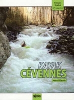
£17.99
Kavango Region of north-eastern Namibia along the Okavango River on a double-sided map from the Namibian national survey organization combining four maps, information on climate & languages, tourist tips, etc.A general map at 1:500, 000 provides an overview of the area. Roads & tracks indicate scenic sections & symbols mark locations of various facilities including tourist accommodation, fuel supplies, medical centres, etc. The base map derived from satellite imagery is coloured according to different types of vegetation. On the reverse three large panels provide extracts from Namibia’s topographic survey: the Khaudum Game Park at 1:250, 000, plus Divundu & Mahango Park & the environs of Rundu at 1:50, 000, again showing various facilities & sites of tourist interest. The maps have latitude & longitude grid lines for GPS navigation. The map also

Includes::
a distance table & driving tips, information about local population & its different languages, notes about malaria, climate charts, etc.

...
Archived Product
£11.50
One of the titles in the topographic survey of the coastal part of French Guiana, published as an extension of IGN’s survey of France to its overseas departments. Contours are at 5m intervals & the maps indicate 13 different types of vegetation & land use, including rain forest, brushwood, savanna, high & low mangrove, rice fields, orchards & plantations, etc. The extent of changes in the coastline in the recent decades is indicated. The maps have a UTM grid & latitude/longitude lines at intervals of 5’. Map legend

Includes::
English.

...
Archived Product
£8.95
Kaweka & Kaimanawa Recreation Areas in a series of topographic maps of popular walking & recreational areas with contours at 20m intervals & relief shading. Perennial snow & ice contours are marked in blue & terrain information

Includes::
cliffs, saddles, moraine, scree, forest, scrub, etc. The maps show tracks & footpaths, with some paths indicating walking distances between marked points. A range of symbols depict campsites, huts, shelters, toilets & parking areas, fuel supplies, places of interest, etc. Latitude & longitude margin ticks are at 1' intervals, & the New Zealand Map Grid is printed over the map. In this title: double-sided map covering the Kaimanawa Forest Park & the Kaweka Forest Park, extending south-east from Turangi.

...
Archived Product
£9.95
This book describes KZN`s national monuments & heritage sites & conservancies (including two World Heritage Sites) in a way that makes them accessible & interesting to travellers as well as those who live in the province. It is intended to encourage a greater interest in the history & culture of the province, providing new options for visitors & a deeper or broader perspective on the many interesting areas to be discovered or seen again in this part of the country. The book

Includes::
precise & detailed maps & is illustrated with full-colour photographs. It is divided into the main geographic areas to facilitate its use as a travel guide. They include:
- Durban & surrounding areas
- Northern & Central Kwazulu Natal
- Pietermaritzburg
- Southern Kwazulu Natal
- The Greater St Lucia Wetlands
- UKhahlamba-Drakenserg World Heritage Site
- Zululand & Maputoland


...
Archived Product
£24.99
Fairy tale finesse: Reviving East of the Sun & West of the Moon, Kay Nielsen`s most ambitious illustration project Step into a world of star-crossed lovers, magical winds, mischievous giants, & trolls, through some of themost exquisite illustrations in publishing history. In this gorgeous reprint, TASCHEN revives the most ambitious publication project of beloved Danish artist Kay Nielsen, one of the most famous children s book illustrators of all time. First published in 1914, East of the Sun & West of the Moonis a celebrated collection offifteen fairy tales, gathered by legendary Norwegian folklorists Peter Christen Asbjornsen & Jorgen Engebretsen Moeon their journeys across Norway in the mid-nineteenth century. Nielsen s illustration edition of Asbjornsen & Moe s tales is considereda jewel of early 20th-century children`s literature, highly sought-after by art & book collectors worldwide. An original signed copy of the book sold at auction in 2008 commanded the highest price ever paid for an illustrated children s book. This finely crafted reprint restores the stunning detail & artistry of Nielsen s images to their original splendor. Featuring 46 illustrations, including many enlarged details from Nielsen s rare original watercolors, the book is printed in five colors with a lovingly designed slipcase. Three accompanying essays, illustrated with dozens of rare & previously unseen artworks by Nielsen, explore the history of Norwegian folktales, Nielsen s life & work, & how this masterpiece came to be. ” ...
Archived Product
£9.99
Loel Collins draws on his experience to help the readers learn to roll a kayak or improve the roll they already have. The approach is to illustrate the ideas with clear photo sequences, keeping the text to a minimum. Rolling is learnt by working through a sequence of exercises to allow the learner to `feel` what is required. Once the initial sequences have been learnt, problems are identified & solved. The learners are then provided with exercises to prepare them for the challenges involved in rolling in rough water & given advice on how to cope when they get there. For those who wish to improve an unreliable roll, a flow chart helps them to plan a learning sequence & choose the appropriate exercises. Although aimed at kayakers, the book is also a mine of useful tools for the coach looking for tools that they can use when teaching rolling. ...
Archived Product
£8.99
Kayaking is a tremendously wide--ranging sport. You can go for a leisurely paddle on your local pond, travel down a river or experience the thrills of ehite water. It is truly a sport for life. This lavishly--illustrated, clearly--written guide will have you out on the water fast -- & in safety. It covers: * How to get started * The equipment youa ll need * Launching * how to control the boat * Basic manoeuvres * What to do if you capsize * The Eskimo roll * Rescue procedures. ...
Archived Product
£21.99
This is a modern illustrated `how to` guide to kayaking, with authoritative information for beginners as well as the experienced paddler, all delivered with humour & enthusiasm. Presented in colour with easy-to-follow, step-by-step photographic sequences & inspirational action images, this manual covers everything from flat water through to ocean paddling, white water & surfing. The book also explains the clothing & equipment required for every type of kayaking &, of course, the boats & paddles themselves, as well as weather, hydrodynamics, safety & rescue. ...
Archived Product
£17.99
The 1:50 000 topographic map gives a more general picture of the ground features than a basic map. It shows settlements, houses, roads, cultivated areas, waterways, cutting areas, mires, rock exposures, & relief. One map sheet covers an area of 30 x 40 km & one centimetre corresponds to 500 metres on the ground. The 1:50, 000 topographic map is also an ideal complement to nautical charts as it provides useful information about the land areas adjacent to waterways. For example, all Finnish sea areas are covered by 1:50 000 topographic map sheets. ...
Archived Product
£9.95
Indexed, double-sided map of Kazakhstan printed on waterproof & tear-resistant paper, with plans of central Almaty & Astana. Topography is shown by altitude colouring with spot heights, indicating swamps & slat flats, seasonal rivers & lakes, deserts, etc. Around the Aral Sea the water level in 1960 is marked. The map shows the country ...
Archived Product

Kayak Cevennes

Kayak Cevennes is a full bilingual kayaking guidebook (French & English text) which describes 44 rivers South-East of the French Massif Central - 68 runs from grade 3 to 6. It includes well-known rivers such as ”Haut Tarn”, ”Dourbie”, ”Bourges”, as well as many unknown runs. 5 Freestyle playspots are also described. Rivers are introduced by well known paddlers: the ”Haut Tarn” by Jay Sigbrandt, the ”Drobie” by Paul Villecourt, the ”Glueyre” by Simon Leveque (Canada), the ”Beaume” by Jean Lamy, etcetera.
RIP - This product is no longer available on our network. It was last seen on 25.09.2019

This page now acts as a permanent archive for this product. Add more information using the comments box below to ensure it can still be found by future generations.

Use our search facility to see if it is available from an alternative contributor.
  • External links may include paid for promotion
  • Availability: Out Of Stock
  • Supplier: Stanfords
  • SKU: 9782910197230
Availability: In Stock
£24.95

Product Description

Kayak Cevennes is a full bilingual kayaking guidebook (French & English text) which describes 44 rivers South-East of the French Massif Central
- 68 runs from grade 3 to 6. It

Includes::
well-known rivers such as ” Haut Tarn”, ” Dourbie”, ” Bourges”, as well as many unknown runs. 5 Freestyle playspots are also described. Rivers are introduced by well known paddlers: the ” Haut Tarn” by Jay Sigbrandt, the ” Drobie” by Paul Villecourt, the ” Glueyre” by Simon Leveque (Canada), the ” Beaume” by Jean Lamy, etcetera.

Reviews/Comments

Add New

Intelligent Comparison

Oooops!
We couldn't find anything!
Perhaps this product's unique.... Or perhaps we are still looking for comparisons!
Click to bump this page and we'll hurry up.

Price History

Vouchers

No voucher codes found.
Do you know a voucher code for this product or supplier? Add it to Insights for others to use.

Facebook

Jargon Buster

Supplier Information

Stanfords
Stanfords was established in 1853 and opened their iconic Covent Garden flagship store in 1901. They have become the top retailer of maps, travel books and accessories in the UK and arguably offer the largest selection of maps and travel books worldwide. Famous names such as Captain Robert Falcon Scott, Ranulph Fiennes and Michael Palin have purchased from Stanfords. They now have a shop in Bristol and both stores together with other venues operate a calendar of events including talks, book signings and exhibitions. As a specialist map retailer, the map selection is comprehensive and includes road maps, street maps and walking maps from worldwide destinations, as well as a selection of world atlases and wall maps. Books include travel guides and travel literature. Stanfords also stock globes, from miniatures made of blue marble to magnificent floor-standing globes. The website features a selection of interesting articles on travel topics.
Page Updated: 2023-11-12 20:15:36

Community Generated Product Tags

Oh No! The productWIKI community hasn't generated any tags for this product yet!
Menu