
 United Kingdom
 France
 Germany
 Netherlands
 Sweden
 USA
USA
 Italy
Italy
 Spain
Spain
More From Contributor


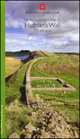
Hadrian`s Wall Archaeological Map
Hadrian’s Wall and the nearby archaeological Roman remains on a light, waterproof and tear-resistant map from the English Heritage with the base map from the Ordnance Survey 1:25, 000 Explorer series.The map presents in six panels the whole course of the wall including its sections across the present day Newcastle, plus the adjoining area along the Irish Sea coast. Cartography of the Ordnance Survey Explorer series has its standard colouring faded out to provide a clearer base for highlighting all the elements of the Roman frontiers which can be readily depicted at this scale. The map shows not only the wall and its fortifications, but also nearby camps, civil settlements, temples, bathhouses, quarries, watermills, kilns, etc, distinguishing between visible sites and those no
longer there but known or strongly presumed to have existed. All the panels have the lines of the British National Grid at 1km intervals.
longer there but known or strongly presumed to have existed. All the panels have the lines of the British National Grid at 1km intervals.

Product Description
Reviews/Comments
Add New
Vouchers
No voucher codes found.
Do you know a voucher code for this product or supplier? Add it to Insights for others to use.
Do you know a voucher code for this product or supplier? Add it to Insights for others to use.
 Denmark