
 United Kingdom
 France
 Germany
 Netherlands
 Sweden
 USA
USA
 Italy
Italy
 Spain
Spain
More From Contributor


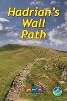
Hadrian`s Wall Path
Hadrian`s Wall Path, a 138km / 86 mile long trail from Bowness-on-Solway to Wallsend along the remains of the Roman walls and forts, presented by Rucksack Readers in handy A5 size, spiral-bound, waterproof guide with mapping at 1:100, 000. The 64-page guide provides general advice on when to go, availability of accommodation, etc, and includes notes on archaeology, the industrial heritage of the Tyneside, geology, habitats and wildlife. Detailed route descriptions, arranged in daily stages, are preceded by a summary of each section of the route giving distance, terrain, grade, and availability of food and drink. The guide is illustrated with numerous colour photos.The route is highlighted on fold-out map at 1:100, 000. The map has altitude colouring to show the topography
and also indicates various facilities and places of interest. No geographical coordinates for GPS users are provided. The publishers themselves recommend that their guide is used in conjunction with more detailed, contoured and GPS compatible maps. To see other titles in this series please click on the series link.
and also indicates various facilities and places of interest. No geographical coordinates for GPS users are provided. The publishers themselves recommend that their guide is used in conjunction with more detailed, contoured and GPS compatible maps. To see other titles in this series please click on the series link.

Product Description
Reviews/Comments
Add New
Vouchers
No voucher codes found.
Do you know a voucher code for this product or supplier? Add it to Insights for others to use.
Do you know a voucher code for this product or supplier? Add it to Insights for others to use.
 Denmark