
 United Kingdom
 France
 Germany
 Netherlands
 Sweden
 USA
USA
 Italy
Italy
 Spain
Spain
More From Contributor


Global Mapping Political World Wall Map: EXTRA LARGE
Extra large, 195 x 120cm, political map of the world from Global Mapping with countries shown in bright vivid colours against light blue oceans at 1:20, 000, 000. Country names are in large, clearly legible print. English versions of all city names are used throughout, major airports are displayed.The map has well designed relief shading to show the mountainous areas like the Rockies or the Andes, enhancing the overall presentation; selected spot heights are also given. Lines of latitude and longitude are marked at 10
Product Description
Reviews/Comments
Add New
Intelligent Comparison
Archived Product
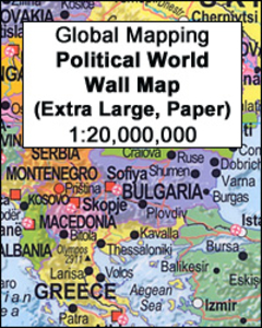
Global Mapping Political World Wall Map EXTRA LARGE, PAPER Stanfords
£22.99
Archived Product
Global Mapping Political World Wall Map A3 PAPER Stanfords
£4.99
Archived Product

World Global Mapping Political Wall Map LARGE PAPER Stanfords
£11.99
Archived Product
Global Mapping Antique Style Political World Wall Map Stanfords
£9.99
Archived Product
Europe: Global Mapping Political Wall Map ENCAPSULATED Stanfords
£23.99
Archived Product
Europe: Global Mapping Political Wall Map PAPER Stanfords
£10.99
Archived Product
Europe: Global Mapping Political Wall Map PAPER Stanfords
£10.99
Archived Product
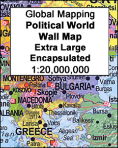
World Global Mapping Political Wall Map X-LARGE ENCAPSULATED Stanfords
£39.99
Vouchers
No voucher codes found.
Do you know a voucher code for this product or supplier? Add it to Insights for others to use.
Do you know a voucher code for this product or supplier? Add it to Insights for others to use.
 Denmark