More From Contributor

£5.00
In this radical & wide-ranging reassessment of Renaissance art, Jerry Brotton & Lisa Jardine examine the ways in which European culture came to define itself culturally & aesthetically in the years 1450 to 1550. Looking outwards for confirmation of who they were & of what defined them as civilized`, Europeans encountered the returning gaze of what we now call the East, in particular the powerful Ottoman Empire of Mehmed the Conqueror & Suleyman the Magnificent. ” Global Interests” explores these historical interactions by offering new & exciting accounts of three often neglected art objects: portrait medals, tapestries & equestrian art. The portability of medals & tapestries, & the transportability of, & esteem accorded to, pure-bred Eastern horses made them frequently exchanged objects, &, as such, highly revealing of the cultural currents flowing between Occident & Orient. The authors provide fascinating new responses to some of the most iconic paintings of the period, including the work of Pisanello, Leonardo, Durer, Holbein & Titian.” Global Interests” also offers a timely reassessment of the development of European imperialism, focusing on the Habsburg Empire of Charles V, & concludes with a consideration of the impact this history continues to have upon contemporary perceptions of European culture & ethnic identity. ...
Archived Product
£9.99
Political wall map of the world at 1:40, 000, 000 from Global Mapping, size 100 x 57.5 cm (39.5 x 22.5 approx), in an antique style of presentation with the countries in pleasant subdued colours & the oceans with graphics to show the ridges, etc. A useful enlargement presents Europe in greater clarity. Countries are presented in pleasant subdued colours against the oceans in light beige. Current edition of this map shows South Sudan. Country names are in their English versions; cities are in the language of the country so Warszawa, Wien, Al Qahira, etc. In USA, Canada, Brazil, Argentina & Australia boundaries & names of the states/provinces are shown. The map shows main road & rail connections & principal airports. Land masses have subtle relief shading with names of important geographical features & largest mountains. Graphic relief shows the ocean floor with ridges, trenches, etc. Clocks indicate change in local time from GMT at 60 ...
Archived Product
£75.00
The 1:30M version won Best Printed Map from the British Cartographic Society (BCS) who also awarded it the BCS Cup for the best overall map. The classic design of muted colours & hill shading give an antique feel to the map. The map features insets of the two polar regions as well as an enlargement of Central Europe, all with an increased level of detail than the medium map. Uniquely, the map also

Includes::
explanatory text about the Tropics of Cancer & Capricorn, the Arctic & Antarctic Circles as well as an Analemma which shows which day of the year the sun is directly overhead & how sun time compares to clock time.

...
Archived Product
£11.99
Large 136 x 83 cm physical map with international boundaries drawn in red. Close examination reveals land relief finely depicted by hill-shading. Bathymetry is shown with far more generalisation. Land colour ranges from a pale sandy colour for desert to green for forested regions. Major towns, selected rivers & peaks are named. Capital cities are highlighted with red symbols. Time zones are not drawn but a general indication of time differences is provided by clockface symbols placed every 30 ...
Archived Product
£11.99
Large 136x 83cm Physical map with international boundaries drawn in red. Close examination reveals land relief finely depicted by hill-shading. Bathymetry is shown with far more generalisation. Land colour ranges from a pale sandy colour for desert to green for forested regions. Major towns, selected rivers & peaks are named. Capital cities are highlighted with red symbols. Time zones are not drawn but a general indication of time differences is provided by clockface symbols placed every 30deg of longitude. ...
Archived Product
£4.99
A3 size political map of the world from Global Mapping. Given the small size of the map, some country names, particularly within Europe, are shown abbreviated & not all the capital cities are included. Country names are in English; within Europe names of capital cities are shown as used in their countiers (K ...
Archived Product
£22.99
Political map of the world from Global Mapping, extra large size 199 x 135cm (78.5” x 53” approx) – paper version, with bright colouring of the individual countries pleasantly contrasted by the light blue oceans, relief shading for mountain ranges on land & the structure of the ocean floor, a panel of country flags, etc. The map is part of Global Mapping series of political maps presenting the world in four different sizes, as indicated below. This particular version has not yet been updated to show South Sudan or the new International Date Line &, unlike the three smaller versions, does not include a panel of flags.GLOBAL MAPPING POLITICAL MAPS OF THE WORLD:FORMAT &

Sizes:
the maps are available on paper or encapsulated & in four

Sizes:
199 x 135cm, 138 x 95cm, 99.5 x 69.5cm & 69.5 x 61cm on paper but slightly larger when encapsulated – please see individual entries for exact measurements. PRESENTATION: country names are in English. Within Europe, city names are as used in their countries (Köln, Wien, Warszawa); elsewhere the names vary (e.g. Viangchan for Vientiane). In USA, Canada, Brazil & Australia the map shows names of states/provinces, with their borders & administrative capitals. Relief shading shows elevation on land & particularly effectively on the ocean floor. On all four sizes clocks show time difference from GMT (but without indicating the exact geographical area covered by each time zone); the International Date Line is not included on the smallest version. Small, medium & large size versions include a panel of country flags under the map.PLEASE NOTE: as the scale & the size of the map increases, each version

Includes::
more cities & more geographical information (mountain ranges, islands, etc).


...
Archived Product
£25.99
Extra large, 195 x 120cm, political map of the world from Global Mapping with countries shown in bright vivid colours against light blue oceans at 1:20, 000, 000. Country names are in large, clearly legible print. English versions of all city names are used throughout, major airports are displayed. The map has well designed relief shading to show the mountainous areas like the Rockies or the Andes, enhancing the overall presentation; selected spot heights are also given. Lines of latitude & longitude are marked at 10 ...
Archived Product
£25.00
On a world tour through a variety of dramatic landscapes, from the pack ice of the Arctic to the desert wastes of Arabia, ” Global Safari” explores fifty of the most exciting places to watch wildlife, all vividly brought to life by breathtaking nature photography of the highest standard. It looks at what animals can be seen in each place, why they are there, & some of the issues involved in the long-term protection of these places & the flora & fauna they support. The book covers all rare & familiar species alike. Well-known wildlife spectacles such as Polar Bears gathering in autumn on the edge of Canada`s Hudson Bay & rainforest treks in search of the endangered Mountain Gorillas of Central Africa share the stage with less famous but equally astonishing experiences. ...
Archived Product

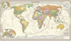
Global Mapping Physical World Wall Map, Pacific Centred

Large 136x83cm Physical map with international boundaries drawn in red. Close examination reveals land relief finely depicted by hill-shading. Bathymetry is shown with far more generalisation. Land colour ranges from a pale sandy colour for desert to green for forested regions.Major towns, selected rivers and peaks are named. Capital cities are highlighted with red symbols. Time zones are not drawn but a general indication of time differences is provided by clockface symbols placed every 30deg of longitude.
RIP - This product is no longer available on our network. It was last seen on 21.11.2018

This page now acts as a permanent archive for this product. Add more information using the comments box below to ensure it can still be found by future generations.

Use our search facility to see if it is available from an alternative contributor.
  • Availability: Out Of Stock
  • Supplier: Stanfords
  • SKU: X122612
Availability: In Stock
£11.99

Product Description

Large 136x 83cm Physical map with international boundaries drawn in red. Close examination reveals land relief finely depicted by hill-shading. Bathymetry is shown with far more generalisation. Land colour ranges from a pale sandy colour for desert to green for forested regions. Major towns, selected rivers & peaks are named. Capital cities are highlighted with red symbols. Time zones are not drawn but a general indication of time differences is provided by clockface symbols placed every 30deg of longitude.

Reviews/Comments

Add New

Intelligent Comparison

Oooops!
We couldn't find anything!
Perhaps this product's unique.... Or perhaps we are still looking for comparisons!
Click to bump this page and we'll hurry up.

Price History

Vouchers

No voucher codes found.
Do you know a voucher code for this product or supplier? Add it to Insights for others to use.

Facebook

Jargon Buster

Physical - Used to describe strength or visual properties of an item
Wall - A physical barrier between two areas
Red - One of the three primary colours
World - A physical grouping, commonly used to describe earth and everything associated with ti
Colour - The categorised spectrum of light visable to humans
Large - something that takes up more space than normal.

Supplier Information

Stanfords
Stanfords was established in 1853 and opened their iconic Covent Garden flagship store in 1901. They have become the top retailer of maps, travel books and accessories in the UK and arguably offer the largest selection of maps and travel books worldwide. Famous names such as Captain Robert Falcon Scott, Ranulph Fiennes and Michael Palin have purchased from Stanfords. They now have a shop in Bristol and both stores together with other venues operate a calendar of events including talks, book signings and exhibitions. As a specialist map retailer, the map selection is comprehensive and includes road maps, street maps and walking maps from worldwide destinations, as well as a selection of world atlases and wall maps. Books include travel guides and travel literature. Stanfords also stock globes, from miniatures made of blue marble to magnificent floor-standing globes. The website features a selection of interesting articles on travel topics.
Page Updated: 2023-11-12 20:15:36

Community Generated Product Tags

Oh No! The productWIKI community hasn't generated any tags for this product yet!
Menu