More From Contributor

£14.99
Packed with over 150 amazing coffee experiences in 37 countries, from its birthplace in East Africa, to modern-day Cuba, the United States, Australia & the UK, this follow-up to our hugely popular Global Beer Tour features legendary espresso bars, plantation tours, urban roasteries & must-visit cafes. Inside this definitive guide to coffee tasting around the world, you`ll discover exactly where to go & what to try, plus illustrated spreads on roasting coffee, cocktails, brewing techniques & more. The places you`ll learn about in Lonely Planet`s Global Coffee Tour & visit aren`t just cafes
- they`re meccas for coffee lovers, offering insight into the local culture & the history, personalities, passion & creativity behind each coffee.- Discover each country`s top five, must-drink coffees
- Learn how to order a coffee in the local language
- Explore each area with our itinerary of local things to do
- Find coffee classes & learn about roasting & brewing
- Packed with photos of coffee houses the world over


...
Archived Product
£12.99
` If I were a voter in Britain, I would vote for [ Jeremy Corbyn]`
- Noam Chomsky, 2017 Global Discontents is an essential guide
...
Archived Product
£16.99
Today`s global energy system faces two major challenges: how to secure the supply of reliable & affordable energy; & how to rapidly transform to a low-carbon, efficient & environmentally harmless energy supply. In this rigorous & illuminating book, Michael Bradshaw explores the key aspects of the current global energy dilemma & examines how it is playing out across the major regions & countries of the world. The book begins by charting the development of the current global energy system
- exploring its key characteristics with a focus upon energy security & the relationship between energy, economic development & climate change. The next four chapters offer in-depth analyses of four distinct global energy dilemmas in different parts of the world: the challenge of sustaining affluence & decarbonising energy services in the high-energy economies of the developed world; the legacies of the centrally planned economy & the consequences of liberalisation in the post-socialist world; growing energy demand & emissions growth associated with the emerging regions; & finally, the quest to provide universal access to modern energy services in the developing world in a manner that is both economically & environmentally sustainable. Identifying the governance structures & policy options available to tackle the global energy dilemma, the book concludes that only an integrated approach
- sensitive to regional issues
- can reconcile the interests & needs of those facing differing energy challenges across the world today.


...
Archived Product
£5.00
In this radical & wide-ranging reassessment of Renaissance art, Jerry Brotton & Lisa Jardine examine the ways in which European culture came to define itself culturally & aesthetically in the years 1450 to 1550. Looking outwards for confirmation of who they were & of what defined them as civilized`, Europeans encountered the returning gaze of what we now call the East, in particular the powerful Ottoman Empire of Mehmed the Conqueror & Suleyman the Magnificent. ” Global Interests” explores these historical interactions by offering new & exciting accounts of three often neglected art objects: portrait medals, tapestries & equestrian art. The portability of medals & tapestries, & the transportability of, & esteem accorded to, pure-bred Eastern horses made them frequently exchanged objects, &, as such, highly revealing of the cultural currents flowing between Occident & Orient. The authors provide fascinating new responses to some of the most iconic paintings of the period, including the work of Pisanello, Leonardo, Durer, Holbein & Titian.” Global Interests” also offers a timely reassessment of the development of European imperialism, focusing on the Habsburg Empire of Charles V, & concludes with a consideration of the impact this history continues to have upon contemporary perceptions of European culture & ethnic identity. ...
Archived Product
£9.99
Political wall map of the world at 1:40, 000, 000 from Global Mapping, size 100 x 57.5 cm (39.5 x 22.5 approx), in an antique style of presentation with the countries in pleasant subdued colours & the oceans with graphics to show the ridges, etc. A useful enlargement presents Europe in greater clarity. Countries are presented in pleasant subdued colours against the oceans in light beige. Current edition of this map shows South Sudan. Country names are in their English versions; cities are in the language of the country so Warszawa, Wien, Al Qahira, etc. In USA, Canada, Brazil, Argentina & Australia boundaries & names of the states/provinces are shown. The map shows main road & rail connections & principal airports. Land masses have subtle relief shading with names of important geographical features & largest mountains. Graphic relief shows the ocean floor with ridges, trenches, etc. Clocks indicate change in local time from GMT at 60 ...
Archived Product
£11.99
Large 136 x 83 cm physical map with international boundaries drawn in red. Close examination reveals land relief finely depicted by hill-shading. Bathymetry is shown with far more generalisation. Land colour ranges from a pale sandy colour for desert to green for forested regions. Major towns, selected rivers & peaks are named. Capital cities are highlighted with red symbols. Time zones are not drawn but a general indication of time differences is provided by clockface symbols placed every 30 ...
Archived Product
£11.99
Large 136x 83cm Physical map with international boundaries drawn in red. Close examination reveals land relief finely depicted by hill-shading. Bathymetry is shown with far more generalisation. Land colour ranges from a pale sandy colour for desert to green for forested regions. Major towns, selected rivers & peaks are named. Capital cities are highlighted with red symbols. Time zones are not drawn but a general indication of time differences is provided by clockface symbols placed every 30deg of longitude. ...
Archived Product
£4.99
A3 size political map of the world from Global Mapping. Given the small size of the map, some country names, particularly within Europe, are shown abbreviated & not all the capital cities are included. Country names are in English; within Europe names of capital cities are shown as used in their countiers (K ...
Archived Product

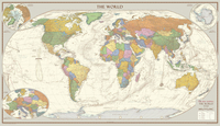
Global Mapping Antique Style World Map - Huge 2000 X 1150 Mm

The 1:30M version won Best Printed Map from the British Cartographic Society (BCS) who also awarded it the BCS Cup for the best overall map. The classic design of muted colours and hill shading give an antique feel to the map. The map features insets of the two polar regions as well as an enlargement of Central Europe, all with an increased level of detail than the medium map. Uniquely, the map also includes explanatory text about the Tropics of Cancer and Capricorn, the Arctic and Antarctic Circles as well as an Analemma which shows which day of the year the sun is directly overhead and how sun time compares to clock time.
RIP - This product is no longer available on our network. It was last seen on 25.09.2019

This page now acts as a permanent archive for this product. Add more information using the comments box below to ensure it can still be found by future generations.

Use our search facility to see if it is available from an alternative contributor.
  • Availability: Out Of Stock
  • Supplier: Stanfords
  • SKU: 9786000539955
Availability: In Stock
£75.00

Product Description

The 1:30M version won Best Printed Map from the British Cartographic Society (BCS) who also awarded it the BCS Cup for the best overall map. The classic design of muted colours & hill shading give an antique feel to the map. The map features insets of the two polar regions as well as an enlargement of Central Europe, all with an increased level of detail than the medium map. Uniquely, the map also

Includes::
explanatory text about the Tropics of Cancer & Capricorn, the Arctic & Antarctic Circles as well as an Analemma which shows which day of the year the sun is directly overhead & how sun time compares to clock time.

Reviews/Comments

Add New

Intelligent Comparison

Oooops!
We couldn't find anything!
Perhaps this product's unique.... Or perhaps we are still looking for comparisons!
Click to bump this page and we'll hurry up.

Price History

Vouchers

No voucher codes found.
Do you know a voucher code for this product or supplier? Add it to Insights for others to use.

Facebook

Jargon Buster

Clock - A device used for telling the time
antique - An old collectible item with desirable qualities.
sun - A star at the centre of the solar system.
World - A physical grouping, commonly used to describe earth and everything associated with ti
Day - The time it takes a planet or other space objects to complete one rotation.
Year - The time it takes the planet earth to orbit the sun. This takes around 365.25 days.
Year - 365 days (366 days in a leap year), the time taken for planet earth to make one full revolution around the sun.
Design - A drawing or styles that shows the look and functionality of something before its made.
Classic - Something that is still like it was originally a high quality standard.

Supplier Information

Stanfords
Stanfords was established in 1853 and opened their iconic Covent Garden flagship store in 1901. They have become the top retailer of maps, travel books and accessories in the UK and arguably offer the largest selection of maps and travel books worldwide. Famous names such as Captain Robert Falcon Scott, Ranulph Fiennes and Michael Palin have purchased from Stanfords. They now have a shop in Bristol and both stores together with other venues operate a calendar of events including talks, book signings and exhibitions. As a specialist map retailer, the map selection is comprehensive and includes road maps, street maps and walking maps from worldwide destinations, as well as a selection of world atlases and wall maps. Books include travel guides and travel literature. Stanfords also stock globes, from miniatures made of blue marble to magnificent floor-standing globes. The website features a selection of interesting articles on travel topics.
Page Updated: 2023-11-12 20:15:36

Community Generated Product Tags

Oh No! The productWIKI community hasn't generated any tags for this product yet!
Menu