
 United Kingdom
 France
 Germany
 Netherlands
 Sweden
 USA
USA
 Italy
Italy
 Spain
Spain
More From Contributor


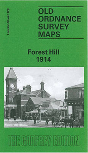
Forest Hill 1914
Forest Hill in 1914 in a fascinating series of reproductions of old Ordnance Survey plans in the Alan Godfrey Editions, ideal for anyone interested in the history of their neighbourhood or family. Two versions cover this area, stretching from Honor Oak Road and Dartmouth Road eastward to Nelgarde Road and Berlin Road. The west side of the map covers the Forest Hill area, around and including the station, extending north to the south side of Honor Oak Park station. On the east side of the map are Catford and Catford Bridge stations, St Dunstan`s College and Ladywell Recreation Ground. Stanstead Road runs between the two areas, and to the north of this are Brockley Rise, Brockley Hill and Ravensbourne Park. The various churches - Christ Church, St George`s, St Saviour`s Brockley
Rise, St Paul`s - reflect the development of the estates. There are street directory extracts on both maps.About the Alan Godfrey Editions of the 25” OS SeriesSelected towns in Great Britain and Ireland are covered by maps showing the extent of urban development in the last decades of the 19th and early 20th century. The plans have been taken from the Ordnance Survey mapping and reprinted at about 15 inches to one mile (1:4, 340). On the reverse most maps have historical notes and many also include extracts from contemporary directories. Most maps cover about one mile (1.6kms) north/south, one and a half miles (2.4kms) across; adjoining sheets can be combined to provide wider coverage.FOR MORE INFORMATION AND A COMPLETE LIST OF ALL AVAILABLE TITLES PLEASE CLICK ON THE SERIES LINK.
Rise, St Paul`s - reflect the development of the estates. There are street directory extracts on both maps.About the Alan Godfrey Editions of the 25” OS SeriesSelected towns in Great Britain and Ireland are covered by maps showing the extent of urban development in the last decades of the 19th and early 20th century. The plans have been taken from the Ordnance Survey mapping and reprinted at about 15 inches to one mile (1:4, 340). On the reverse most maps have historical notes and many also include extracts from contemporary directories. Most maps cover about one mile (1.6kms) north/south, one and a half miles (2.4kms) across; adjoining sheets can be combined to provide wider coverage.FOR MORE INFORMATION AND A COMPLETE LIST OF ALL AVAILABLE TITLES PLEASE CLICK ON THE SERIES LINK.

Product Description
Reviews/Comments
Add New
Intelligent Comparison
Archived Product

Shooters Hill 1914 Stanfords
£3.50
Archived Product

Buckhurst Hill 1914 Stanfords
£3.50
Archived Product
Notting Hill 1914 Stanfords
£2.95
Archived Product

Shooters Hill 1894 Stanfords
£3.50
Vouchers
No voucher codes found.
Do you know a voucher code for this product or supplier? Add it to Insights for others to use.
Do you know a voucher code for this product or supplier? Add it to Insights for others to use.
 Denmark