
 United Kingdom
 France
 Germany
 Netherlands
 Sweden
 USA
USA
 Italy
Italy
 Spain
Spain
More From Contributor


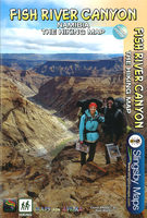
Fish River Canyon
New edition detailed activities map of the Richtersveld and Fish River Canyon including full-colour photographs of activities and areas of interest. Coverage includes a detailed map from Keetmanshoop in the north to Springbok in the south at a 1:476 000 scale, a detailed Richtersveld map at a 1:130 000 scale, a detailed Fish River Canyon map at a 1:116 000 scale, detailed map of the Luderitz Peninsula and town plans of Springbok and Keetmanshoop. Information provided on 4x4 routes, hiking, wild flowers of Namaqualand, tours in the Sperrgebied and rafting on the Orange River. Includes information on towns in the area with contact details, accommodation listings, detailed road structures, terrain map of the Richtersveld and the Fish River Canyon.

Product Description
Reviews/Comments
Add New
Vouchers
No voucher codes found.
Do you know a voucher code for this product or supplier? Add it to Insights for others to use.
Do you know a voucher code for this product or supplier? Add it to Insights for others to use.
 Denmark