
 United Kingdom
 France
 Germany
 Netherlands
 Sweden
 USA
USA
 Italy
Italy
 Spain
Spain
More From Contributor


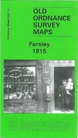
Farsley 1915
Farsley in 1915 in a fascinating series of reproductions of old Ordnance Survey plans in the Alan Godfrey Editions, ideal for anyone interested in the history of their neighbourhood or family. The map covers the small town of Farsley, west of Leeds. Most of the town centre is shown and coverage includes Farsley Beck Bottom and Bagley, continuing north to the western tip of Rodley and westward to Woodhall Hill. Features include Sunny Bank Mill, St John`s church (at foot of map), Springfield Mills, The Green, Bank Bottom Mills, Wadlands Hall, Holly Park Mills (near top left corner), Peel Ings Foundry, Broom Mills, etc. On the reverse is a 1922 directory of Farsley.About the Alan Godfrey Editions of the 25” OS Series:Selected towns in Great Britain and Ireland are covered by
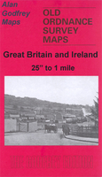
maps showing the extent of urban development in the last decades of the 19th and early 20th century. The plans have been taken from the Ordnance Survey mapping and reprinted at about 15 inches to one mile (1:4, 340). On the reverse most maps have historical notes and many also include extracts from contemporary directories. Most maps cover about one mile (1.6kms) north/south, one and a half miles (2.4kms) across; adjoining sheets can be combined to provide wider coverage.FOR MORE INFORMATION AND A COMPLETE LIST OF ALL AVAILABLE TITLES PLEASE CLICK ON THE SERIES LINK.
maps showing the extent of urban development in the last decades of the 19th and early 20th century. The plans have been taken from the Ordnance Survey mapping and reprinted at about 15 inches to one mile (1:4, 340). On the reverse most maps have historical notes and many also include extracts from contemporary directories. Most maps cover about one mile (1.6kms) north/south, one and a half miles (2.4kms) across; adjoining sheets can be combined to provide wider coverage.FOR MORE INFORMATION AND A COMPLETE LIST OF ALL AVAILABLE TITLES PLEASE CLICK ON THE SERIES LINK.

Product Description
Reviews/Comments
Add New
Intelligent Comparison
Archived Product

Parsloes 1915 Stanfords
£3.50
Archived Product

Calverley 1915 Stanfords
£3.50
Archived Product
Stanley 1915 Stanfords
£3.50
Archived Product

Barnsley 1904 Stanfords
£3.50
Archived Product

Wordsley 1901 Stanfords
£3.50
Archived Product

Bardsley 1906 Stanfords
£3.50
Archived Product
Wordsley 1901 Stanfords
£2.95
Archived Product

Kearsley 1907 Stanfords
£3.50
Vouchers
No voucher codes found.
Do you know a voucher code for this product or supplier? Add it to Insights for others to use.
Do you know a voucher code for this product or supplier? Add it to Insights for others to use.
 Denmark