More From Contributor

£30.00
A colourful cushion with a map of Europe in 1665 from the British Library archives, part of a sophisticated & decorative collection from We Love Cushions designed to bring life & style to any room setting. Countries are in different colours, offset by the light beige colouring of the seas. The cover, printed using archival inks to get the brightest finish possible, with a super soft cotton linen mix, & comes complete with the cushion pad washable at 30º. To see other cushion designs in this series please lick on the series link. ...
Archived Product
£30.00
A colourful cushion with a map of Europe in 1672 from the British Library archives, part of a sophisticated & decorative collection from We Love Cushions designed to bring life & style to any room setting. The image was taken from one of the earliest world atlases published in Amsterdam by the famous Blaeus family of cartographers. The cover, printed using archival inks to get the brightest finish possible, with a super soft cotton linen mix, & comes complete with the cushion pad washable at 30º. To see other cushion designs in this series please lick on the series link. ...
Archived Product
£12.00
Best known as the author of ` The Road to Oxiana` (published in 1937), Robert Byron developed his considerable writing skills on a travel book which has not been in print since 1926. ` Europe in the Looking Glass` describes a journey Byron made with three friends, driving across Europe between two world wars, & mixes political & historical analysis with architectural insights, classical scholarship & the day-to-day adventures of three young & not very experienced travellers. For fans of Robert Byron`s work this will be a discovery; for others it will be an introduction. ...
Archived Product
£6.99
This Insight Guides Travel Map of Europe is a double-sided, indexed, road map at 1:2.5 Million. Western Russia, Turkey, Iceland & eastern Ukraine are shown at 1:4.5 Million. This map comes with an extensive index booklet, which is attached to the front cover. ...
Archived Product
£12.99
Europe Long-distance Traffic routes map at 1:3, 600, 000 from Kümmerly + Frey presenting the network of roads, railways & ferry connections on a political base with countries shown in different colours. Names of countries are indicated by their number plate codes (GB, F, DK, etc). Names of cities & geographical features are in their original versions, so: Moskva, Wien & Warszawa or Carpatii Orientali, Egéo Pélagos & Bottniska Viken. Main seas have trilingual names: Baltic Sea – Mer Baltique – Ostsee. Coverage

Includes::
the whole of Scandinavia & Icel&, extending east to Moscow, the western coast of the Black Sea & Istanbul. The map highlights motorways & connecting dual carriageway road, & shows a selection of smaller local roads. Driving distances are marked on main routes. Map legend

Includes::
English & provides a list of number plate abbreviations with corresponding country names.* The same information but without the driving distances is also available on two maps from Kümmerly + Frey covering Europe at 1:4, 500, 000. These maps have a choice of a physical or a political base, are available as a folded map or a wall map, & extend further east & south than this title.


...
Archived Product
£18.99
Europe’s network of roads, railways & ferry connections presented by Kümmerly + Frey on a wall map at 1:4, 500, 000, size 126 x 100cm (49.5” x 39.5” approx), in a physical version with relief shading to show mountain ranges & the surrounding seas in light blue. Names of countries, cities & geographical features are in their original versions, so: Magyarország, Shqipëria & Ellada; Moskva, Wien & Warszawa; Carpatii Orientali, Egéo Pélagos & Bottniska Viken. Main seas have trilingual names: Baltic Sea – Mer Baltique – Ostsee. Coverage

Includes::
the whole of Scandinavia & Icel&, extending south to include the Mediterranean coast of Africa & east just beyond the Urals & to the Caspian Sea & the Aral Sea. Latitude & longitude lines are drawn at 4° intervals. Multilingual map legend

Includes::
English. The same information is also available as:* An identical map but in a folded format.* A map with a political rather than a physical base, showing countries in different colours, available either as a wall map or folded.* The political version enlarged to 1:3, 600, 000, with larger easier to read print, driving distances on main routes & country names expressed by their number plate codes (H, AL, GR). This version, Europe Long-distance Traffic Routes, extends less far in the east & south & is available folded only.


...
Archived Product
£13.50
Europe’s network of roads, railways & ferry connections presented by Kümmerly + Frey on a wall map at 1:4, 500, 000, size 126 x 100cm (49.5” x 39.5” approx), in a political version with countries shown in pleasant pastel colours & the surrounding seas in light blue. Names of countries, cities & geographical features are in their original versions, so: Magyarország, Shqipëria & Ellada; Moskva, Wien & Warszawa; Carpatii Orientali, Egéo Pélagos & Bottniska Viken. Main seas have trilingual names: Baltic Sea – Mer Baltique – Ostsee. Coverage

Includes::
the whole of Scandinavia & Icel&, extending south to include the Mediterranean coast of Africa & east just beyond the Urals & to the Caspian Sea & the Aral Sea. Latitude & longitude lines are drawn at 4° intervals. Multilingual map legend

Includes::
English.


...
Archived Product
£18.99
Europe’s network of roads, railways & ferry connections presented by Kümmerly + Frey on a wall map at 1:4, 500, 000, size 126 x 100cm (49.5” x 39.5” approx), in a political version with countries shown in pleasant pastel colours & the surrounding seas in light blue. Names of countries, cities & geographical features are in their original versions, so: Magyarország, Shqipëria & Ellada; Moskva, Wien & Warszawa; Carpatii Orientali, Egéo Pélagos & Bottniska Viken. Main seas have trilingual names: Baltic Sea – Mer Baltique – Ostsee. Coverage

Includes::
the whole of Scandinavia & Icel&, extending south to include the Mediterranean coast of Africa & east just beyond the Urals & to the Caspian Sea & the Aral Sea. Latitude & longitude lines are drawn at 4° intervals. Multilingual map legend

Includes::
English. The same information is also available as:* An identical map but in a folded format.* Enlarged to 1:3, 600, 000, with larger easier to read print, driving distances on main routes & country names expressed by their number plate codes (H, AL, GR). This version, Europe Long-distance Traffic Routes, extends less far in the east & south & is available folded only.* A map with a physical rather than a political base, available either as a wall map or folded.


...
Archived Product
£15.50
Large physical map of Europe with political boundaries, showing the railway network graded into 18 different types of lines. The base map with very fine cartography clearly shows various mountain ranges. Coverage extends to beyond the Urals & the eastern side of the Caspian Sea, large part of the Middle East with most of Iraq & Iran, & the coast of North Africa, &

Includes::
railway lines in all these areas. Country & geographical names are in English & cities in local languages with, where appropriate, English versions. In countries using other alphabets, larger cities are in addition given in Cyrillic, Greek, Arabic, etc. The railway network distinguishes 18 different types of lines, from new high speed lines or upgraded high speed lines to narrow gauge electrified or non-electrified. Railway ferry lines, passenger or freight, are also marked. Map legend is in English, German, French, Italian, Spanish & Russian. Also included is a panel with flags & details of area, population & the length of rail network for all European countries.

...
Archived Product
£6.99
With an easy-fold, easy-to-use format, Lonely Planet Europe Planning Map is your conveniently-sized passport to traveling with ease. Get more from your map & your trip with images & information about top country attractions, itinerary suggestions & themed lists. With this easy-to-use, full colour navigation tool in your rear pocket, you can truly get to the heart of the Europe, so begin your journey now!- Easy-fold format- Handy slipcase- Full colour & easy-to-use- Beautiful imagery- Tailored itineraries- Can`t-miss regional highlights- Detailed town index- Themed lists- Covers London, Paris, Berlin, Rome, Venice, Barcelona, Lisbon, Granada, Amsterdam, Vienna, the Matterhorn, Athens, Santorini, Istanbul, Budapest, Dubrovnik, Prague, Transylvania, British Isles, Western Europe, Central Europe, Mediterranean Europe, Eastern Europe, Scandinavia & the Baltic Sea ...
Archived Product

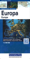
Europe K+F Physical Map

Europe’s network of roads, railways and ferry connections presented by Kümmerly + Frey on a map at 1:4, 500, 000 in a physical version with relief shading to show mountain ranges and the surrounding seas in light blue.Names of countries, cities and geographical features are in their original versions, so: Magyarország, Shqipëria and Ellada; Moskva, Wien and Warszawa; Carpatii Orientali, Egéo Pélagos and Bottniska Viken. Main seas have trilingual names: Baltic Sea – Mer Baltique – Ostsee.Coverage includes the whole of Scandinavia and Iceland, extending south to include the Mediterranean coast of Africa and east just beyond the Urals and to the Caspian Sea and the Aral Sea. Latitude and longitude lines are drawn at 4° intervals. Multilingual map legend includes English.The
map cover provides a time zones map of the world, plus climate information for six locations in Europe: Narvik, Copenhagen, Zurich, Kiev, Rome and Lisbon.The same information is also available as:* An identical wall map.* A map with a political rather than a physical base, showing countries in different colours, available either as a wall map or folded.* The political version enlarged to 1:3, 600, 000, with larger easier to read print, driving distances on main routes and country names expressed by their number plate codes (H, AL, GR). This version, Europe Long-distance Traffic Routes, extends less far in the east and south and is available folded only.
RIP - This product is no longer available on our network. It was last seen on 25.09.2019

This page now acts as a permanent archive for this product. Add more information using the comments box below to ensure it can still be found by future generations.

Use our search facility to see if it is available from an alternative contributor.
  • Availability: Out Of Stock
  • Supplier: Stanfords
  • SKU: 9783259014264
Availability: In Stock
£13.50

Product Description

Europe’s network of roads, railways & ferry connections presented by Kümmerly + Frey on a map at 1:4, 500, 000 in a physical version with relief shading to show mountain ranges & the surrounding seas in light blue. Names of countries, cities & geographical features are in their original versions, so: Magyarország, Shqipëria & Ellada; Moskva, Wien & Warszawa; Carpatii Orientali, Egéo Pélagos & Bottniska Viken. Main seas have trilingual names: Baltic Sea – Mer Baltique – Ostsee. Coverage

Includes::
the whole of Scandinavia & Icel&, extending south to include the Mediterranean coast of Africa & east just beyond the Urals & to the Caspian Sea & the Aral Sea. Latitude & longitude lines are drawn at 4° intervals. Multilingual map legend

Includes::
English. The map cover provides a time zones map of the world, plus climate information for six locations in Europe: Narvik, Copenhagen, Zurich, Kiev, Rome & Lisbon. The same information is also available as:* An identical wall map.* A map with a political rather than a physical base, showing countries in different colours, available either as a wall map or folded.* The political version enlarged to 1:3, 600, 000, with larger easier to read print, driving distances on main routes & country names expressed by their number plate codes (H, AL, GR). This version, Europe Long-distance Traffic Routes, extends less far in the east & south & is available folded only.

Reviews/Comments

Add New

Intelligent Comparison

Oooops!
We couldn't find anything!
Perhaps this product's unique.... Or perhaps we are still looking for comparisons!
Click to bump this page and we'll hurry up.

Price History

Vouchers

No voucher codes found.
Do you know a voucher code for this product or supplier? Add it to Insights for others to use.

Facebook

Jargon Buster

Blue - A primary colour
Lisbon - The capital city of Portugal
Physical - Used to describe strength or visual properties of an item
Wall - A physical barrier between two areas
Railways - A set of tracks that have been laid for the purpose of trains to travel up and down them
World - A physical grouping, commonly used to describe earth and everything associated with ti
Network - A link and communication between things. Often computers or people.
Print - A mechanical process of putting text onto paper. It can also relate to a pattern on an item.

Supplier Information

Stanfords
Stanfords was established in 1853 and opened their iconic Covent Garden flagship store in 1901. They have become the top retailer of maps, travel books and accessories in the UK and arguably offer the largest selection of maps and travel books worldwide. Famous names such as Captain Robert Falcon Scott, Ranulph Fiennes and Michael Palin have purchased from Stanfords. They now have a shop in Bristol and both stores together with other venues operate a calendar of events including talks, book signings and exhibitions. As a specialist map retailer, the map selection is comprehensive and includes road maps, street maps and walking maps from worldwide destinations, as well as a selection of world atlases and wall maps. Books include travel guides and travel literature. Stanfords also stock globes, from miniatures made of blue marble to magnificent floor-standing globes. The website features a selection of interesting articles on travel topics.
Page Updated: 2023-11-12 20:15:36

Community Generated Product Tags

Oh No! The productWIKI community hasn't generated any tags for this product yet!
Menu