
 United Kingdom
 France
 Germany
 Netherlands
 Sweden
 USA
USA
 Italy
Italy
 Spain
Spain
More From Contributor


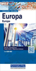


Europe K+F Long-Distance Routes Map
Europe Long-distance Traffic routes map at 1:3, 600, 000 from Kümmerly + Frey presenting the network of roads, railways and ferry connections on a political base with countries shown in different colours. Names of countries are indicated by their number plate codes (GB, F, DK, etc). Names of cities and geographical features are in their original versions, so: Moskva, Wien and Warszawa or Carpatii Orientali, Egéo Pélagos and Bottniska Viken. Main seas have trilingual names: Baltic Sea – Mer Baltique – Ostsee. Coverage includes the whole of Scandinavia and Iceland, extending east to Moscow, the western coast of the Black Sea and Istanbul.The map highlights motorways and connecting dual carriageway road, and shows a selection of smaller local roads. Driving distances are
marked on main routes. Map legend includes English and provides a list of number plate abbreviations with corresponding country names.* The same information but without the driving distances is also available on two maps from Kümmerly + Frey covering Europe at 1:4, 500, 000. These maps have a choice of a physical or a political base, are available as a folded map or a wall map, and extend further east and south than this title.
marked on main routes. Map legend includes English and provides a list of number plate abbreviations with corresponding country names.* The same information but without the driving distances is also available on two maps from Kümmerly + Frey covering Europe at 1:4, 500, 000. These maps have a choice of a physical or a political base, are available as a folded map or a wall map, and extend further east and south than this title.
Product Description
Reviews/Comments
Add New
Vouchers
No voucher codes found.
Do you know a voucher code for this product or supplier? Add it to Insights for others to use.
Do you know a voucher code for this product or supplier? Add it to Insights for others to use.
 Denmark