More From Contributor

£13.50
Europe’s network of roads, railways & ferry connections presented by Kümmerly + Frey on a map at 1:4, 500, 000 in a physical version with relief shading to show mountain ranges & the surrounding seas in light blue. Names of countries, cities & geographical features are in their original versions, so: Magyarország, Shqipëria & Ellada; Moskva, Wien & Warszawa; Carpatii Orientali, Egéo Pélagos & Bottniska Viken. Main seas have trilingual names: Baltic Sea – Mer Baltique – Ostsee. Coverage

Includes::
the whole of Scandinavia & Icel&, extending south to include the Mediterranean coast of Africa & east just beyond the Urals & to the Caspian Sea & the Aral Sea. Latitude & longitude lines are drawn at 4° intervals. Multilingual map legend

Includes::
English. The map cover provides a time zones map of the world, plus climate information for six locations in Europe: Narvik, Copenhagen, Zurich, Kiev, Rome & Lisbon. The same information is also available as:* An identical wall map.* A map with a political rather than a physical base, showing countries in different colours, available either as a wall map or folded.* The political version enlarged to 1:3, 600, 000, with larger easier to read print, driving distances on main routes & country names expressed by their number plate codes (H, AL, GR). This version, Europe Long-distance Traffic Routes, extends less far in the east & south & is available folded only.


...
Archived Product
£18.99
Europe’s network of roads, railways & ferry connections presented by Kümmerly + Frey on a wall map at 1:4, 500, 000, size 126 x 100cm (49.5” x 39.5” approx), in a physical version with relief shading to show mountain ranges & the surrounding seas in light blue. Names of countries, cities & geographical features are in their original versions, so: Magyarország, Shqipëria & Ellada; Moskva, Wien & Warszawa; Carpatii Orientali, Egéo Pélagos & Bottniska Viken. Main seas have trilingual names: Baltic Sea – Mer Baltique – Ostsee. Coverage

Includes::
the whole of Scandinavia & Icel&, extending south to include the Mediterranean coast of Africa & east just beyond the Urals & to the Caspian Sea & the Aral Sea. Latitude & longitude lines are drawn at 4° intervals. Multilingual map legend

Includes::
English. The same information is also available as:* An identical map but in a folded format.* A map with a political rather than a physical base, showing countries in different colours, available either as a wall map or folded.* The political version enlarged to 1:3, 600, 000, with larger easier to read print, driving distances on main routes & country names expressed by their number plate codes (H, AL, GR). This version, Europe Long-distance Traffic Routes, extends less far in the east & south & is available folded only.


...
Archived Product
£13.50
Europe’s network of roads, railways & ferry connections presented by Kümmerly + Frey on a wall map at 1:4, 500, 000, size 126 x 100cm (49.5” x 39.5” approx), in a political version with countries shown in pleasant pastel colours & the surrounding seas in light blue. Names of countries, cities & geographical features are in their original versions, so: Magyarország, Shqipëria & Ellada; Moskva, Wien & Warszawa; Carpatii Orientali, Egéo Pélagos & Bottniska Viken. Main seas have trilingual names: Baltic Sea – Mer Baltique – Ostsee. Coverage

Includes::
the whole of Scandinavia & Icel&, extending south to include the Mediterranean coast of Africa & east just beyond the Urals & to the Caspian Sea & the Aral Sea. Latitude & longitude lines are drawn at 4° intervals. Multilingual map legend

Includes::
English.


...
Archived Product
£18.99
Europe’s network of roads, railways & ferry connections presented by Kümmerly + Frey on a wall map at 1:4, 500, 000, size 126 x 100cm (49.5” x 39.5” approx), in a political version with countries shown in pleasant pastel colours & the surrounding seas in light blue. Names of countries, cities & geographical features are in their original versions, so: Magyarország, Shqipëria & Ellada; Moskva, Wien & Warszawa; Carpatii Orientali, Egéo Pélagos & Bottniska Viken. Main seas have trilingual names: Baltic Sea – Mer Baltique – Ostsee. Coverage

Includes::
the whole of Scandinavia & Icel&, extending south to include the Mediterranean coast of Africa & east just beyond the Urals & to the Caspian Sea & the Aral Sea. Latitude & longitude lines are drawn at 4° intervals. Multilingual map legend

Includes::
English. The same information is also available as:* An identical map but in a folded format.* Enlarged to 1:3, 600, 000, with larger easier to read print, driving distances on main routes & country names expressed by their number plate codes (H, AL, GR). This version, Europe Long-distance Traffic Routes, extends less far in the east & south & is available folded only.* A map with a physical rather than a political base, available either as a wall map or folded.


...
Archived Product
£15.50
Large physical map of Europe with political boundaries, showing the railway network graded into 18 different types of lines. The base map with very fine cartography clearly shows various mountain ranges. Coverage extends to beyond the Urals & the eastern side of the Caspian Sea, large part of the Middle East with most of Iraq & Iran, & the coast of North Africa, &

Includes::
railway lines in all these areas. Country & geographical names are in English & cities in local languages with, where appropriate, English versions. In countries using other alphabets, larger cities are in addition given in Cyrillic, Greek, Arabic, etc. The railway network distinguishes 18 different types of lines, from new high speed lines or upgraded high speed lines to narrow gauge electrified or non-electrified. Railway ferry lines, passenger or freight, are also marked. Map legend is in English, German, French, Italian, Spanish & Russian. Also included is a panel with flags & details of area, population & the length of rail network for all European countries.

...
Archived Product
£6.99
Europe Long-distance Traffic routes map at 1:3, 600, 000 from Kümmerly + Frey presenting the network of roads, railways & ferry connections on a political base with countries shown in different colours. Names of countries are indicated by their number plate codes (GB, F, DK, etc). Names of cities & geographical features are in their original versions, so: Moskva, Wien & Warszawa or Carpatii Orientali, Egéo Pélagos & Bottniska Viken. Main seas have trilingual names: Baltic Sea – Mer Baltique – Ostsee. Coverage

Includes::
the whole of Scandinavia & Icel&, extending east to Moscow, the western coast of the Black Sea & Istanbul. The map highlights motorways & connecting dual carriageway road, & shows a selection of smaller local roads. Driving distances are marked on main routes. Map legend

Includes::
English & provides a list of number plate abbreviations with corresponding country names.* The same information but without the driving distances is also available on two maps from Kümmerly + Frey covering Europe at 1:4, 500, 000. These maps have a choice of a physical or a political base, are available as a folded map or a wall map, & extend further east & south than this title.


...
Archived Product
£17.50
Decorative 108x 150cm wallmap presenting an elevated view of Europe from a position over the Mediterranean Sea, such that Svalbard can be seen disappearing over the northern horizon. The view

Includes::
Iceland & extends as far south as north Africa & the Sinaii Peninsula. Although major roads & towns are depicted, the main emphasis is the physical geography, with relief strongly implied by the use of colour & hill shading. Heights of significant peaks are stated & major rivers & lakes are distinguished. International borders are not indicated.

...
Archived Product
£28.99
Large 140 x 107cm encapsulated political map of Europe from Maps International, at a scale of 1:4, 300, 000. Countries are shown in vivid colours against light blue oceans. Country names are in large, clearly legible print. English versions for capitals & most city names are used, with population information displayed on the legend; international, state & disputed boundaries are displayed. The map has well designed relief shading to show mountainous areas enhancing the overall presentation; the colouring of the oceans shows different depths. Projection is Lamberts Conformal Conic Projection. The map contains a panel of country flags in the map corner.*LAMINATED & ENCAPSULATED WALL MAPS:*- *laminated* wall maps have a thin layer of plastic usually applied to the printed side only. They can be written on with suitable marker pens without any damage to the map but, unless laminated on both sides, they are not damp-proof.- *encapsulated* wall maps are sealed between two sheets of plastic. They are more rigid & heavier than laminated maps of the same size. They are damp-proof & do not crinkle in humid conditions. Encapsulation gives the map a shiny surface, similar to being displayed behind glass.- *please note:* many publishers & retailers often use these two terms interchangeably. Our map titles & descriptions follow the definitions provided above. ...
Archived Product
£19.99
Large 140 x 107cm paper political map of Europe from Maps International, at a scale of 1:4, 300, 000. Countries are shown in vivid colours against light blue oceans. Country names are in large, clearly legible print. English versions for capitals & most city names are used, with population information displayed on the legend; international, state & disputed boundaries are displayed. The map has well designed relief shading to show mountainous areas enhancing the overall presentation; the colouring of the oceans shows different depths. Projection is Lamberts Conformal Conic Projection. The map contains a panel of country flags in the map corner. ...
Archived Product
£37.99
Extra-large 191 x 137cm paper political map of Europe from Maps International, at a scale of 1:3, 200, 000. Countries are shown in vivid colours against light blue oceans. Country names are in large, clearly legible print. English versions for capitals & most city names are used, with population information displayed on the legend; international, state & disputed boundaries are displayed. The map has well designed relief shading to show mountainous areas enhancing the overall presentation; the colouring of the oceans shows different depths. Projection is Lamberts Conformal Conic Projection. The map contains a panel of country flags in the map corner.*LAMINATED & ENCAPSULATED WALL MAPS:*- *laminated* wall maps have a thin layer of plastic usually applied to the printed side only. They can be written on with suitable marker pens without any damage to the map but, unless laminated on both sides, they are not damp-proof.- *encapsulated* wall maps are sealed between two sheets of plastic. They are more rigid & heavier than laminated maps of the same size. They are damp-proof & do not crinkle in humid conditions. Encapsulation gives the map a shiny surface, similar to being displayed behind glass.- *please note:* many publishers & retailers often use these two terms interchangeably. Our map titles & descriptions follow the definitions provided above. ...
Archived Product

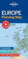
Europe Lonely Planet Planning Map

With an easy-fold, easy-to-use format, Lonely Planet Europe Planning Map is your conveniently-sized passport to traveling with ease. Get more from your map and your trip with images and information about top country attractions, itinerary suggestions and themed lists. With this easy-to-use, full colour navigation tool in your back pocket, you can truly get to the heart of the Europe, so begin your journey now!- Easy-fold format- Handy slipcase- Full colour and easy-to-use- Beautiful imagery- Tailored itineraries- Can`t-miss regional highlights- Detailed town index- Themed lists- Covers London, Paris, Berlin, Rome, Venice, Barcelona, Lisbon, Granada, Amsterdam, Vienna, the Matterhorn, Athens, Santorini, Istanbul, Budapest, Dubrovnik, Prague, Transylvania, British
Isles, Western Europe, Central Europe, Mediterranean Europe, Eastern Europe, Scandinavia & the Baltic Sea
RIP - This product is no longer available on our network. It was last seen on 25.09.2019

This page now acts as a permanent archive for this product. Add more information using the comments box below to ensure it can still be found by future generations.

Use our search facility to see if it is available from an alternative contributor.
  • Availability: Out Of Stock
  • Supplier: Stanfords
  • SKU: 9781786579102
Availability: In Stock
£6.99

Product Description

With an easy-fold, easy-to-use format, Lonely Planet Europe Planning Map is your conveniently-sized passport to traveling with ease. Get more from your map & your trip with images & information about top country attractions, itinerary suggestions & themed lists. With this easy-to-use, full colour navigation tool in your rear pocket, you can truly get to the heart of the Europe, so begin your journey now!- Easy-fold format- Handy slipcase- Full colour & easy-to-use- Beautiful imagery- Tailored itineraries- Can`t-miss regional highlights- Detailed town index- Themed lists- Covers London, Paris, Berlin, Rome, Venice, Barcelona, Lisbon, Granada, Amsterdam, Vienna, the Matterhorn, Athens, Santorini, Istanbul, Budapest, Dubrovnik, Prague, Transylvania, British Isles, Western Europe, Central Europe, Mediterranean Europe, Eastern Europe, Scandinavia & the Baltic Sea

Reviews/Comments

Add New

Intelligent Comparison

Oooops!
We couldn't find anything!
Perhaps this product's unique.... Or perhaps we are still looking for comparisons!
Click to bump this page and we'll hurry up.

Price History

Vouchers

No voucher codes found.
Do you know a voucher code for this product or supplier? Add it to Insights for others to use.

Facebook

Jargon Buster

Lisbon - The capital city of Portugal
Colour - The categorised spectrum of light visable to humans
Heart - An organ that pumps blood around the body. Usually related to love.
Pocket - A bag shaped insert in clothing used to carry items
Regional - An adjective to describe a set geographic area.

Supplier Information

Stanfords
Stanfords was established in 1853 and opened their iconic Covent Garden flagship store in 1901. They have become the top retailer of maps, travel books and accessories in the UK and arguably offer the largest selection of maps and travel books worldwide. Famous names such as Captain Robert Falcon Scott, Ranulph Fiennes and Michael Palin have purchased from Stanfords. They now have a shop in Bristol and both stores together with other venues operate a calendar of events including talks, book signings and exhibitions. As a specialist map retailer, the map selection is comprehensive and includes road maps, street maps and walking maps from worldwide destinations, as well as a selection of world atlases and wall maps. Books include travel guides and travel literature. Stanfords also stock globes, from miniatures made of blue marble to magnificent floor-standing globes. The website features a selection of interesting articles on travel topics.
Page Updated: 2023-11-12 20:15:36

Community Generated Product Tags

Oh No! The productWIKI community hasn't generated any tags for this product yet!
Menu