More From Contributor

£4.99
Devon & western Somerset presented at 1:130, 000 on an indexed Ordnance Survey Tour Map with extensive tourist information including highlighting for national & regional cycle routes. Town navigation maps show main traffic arteries, tourist facilities & sights in Exeter, Plymouth, Bideford, Barnstaple, Brixham, Ilfracombe, Minehead, Newton Abbot, Sidmouth, Taunton, Tiverton, Torquay with Paignton, & Totnes. The map

Includes::
lists of selected places of interest, market days & farmers markets, plus brief notes on the Jurassic Coast World Heritage site. Current edition of this title was published in February 2016. To see the list of titles in this series please click on the series list – Ordnance Survey’s Tour maps have extra clear, uncluttered cartography. Topography is shown by altitude colouring & relief shading, plus names of local hill or mountain ranges & heights of important peaks. Additional colouring indicates woodlands; boundaries of National Parks or designated Areas of Outstanding Natural Beauty are also marked. Road information very clearly distinguishes between different types of roads, from motorways to small local roads, with distances on main routes. Scenic routes are highlighted; motorway services, tolls, gradients on steep roads & level crossings are marked & towns used in motorway signs as Primary Route Destinations are indicated. Railway lines are shown with stations &, where appropriate, ferry routes are marked. Roads which are part of the national or regional cycle network are highlighted & shown with route numbers; the maps also show the National Trail long-distance hiking paths. An extensive range of symbols indicate various places of interest, including campsites/caravan parks & youth hostels/bunkhouses, historic buildings, sport & recreational facilities, country pubs, etc. The maps have lines of the British National Grid. The place names index is supplemented by a list of selected places of interest plus, in most titles, of market days and/or farmers markets. The maps also include city navigation maps, highlighting main traffic arteries, car parks, principal sights & facilities, etc. For more information please see descriptions & coverage images of individual maps.

...
Archived Product
£5.95
Devon, Cornwall & West Somerset road atlas from Geographers’ A-Z Map Company covering the region at 1:158, 400 (1” to 2.5 miles), plus street plans & tourist information for 25 local towns. Numerous places of interest are prominently highlighted on the map & the plans, plus listed in an extensive index. Coverage along the northern coast extends to Weston-super-Mare, & on the southern coast to Lyme Regis & Bridport. Road network is shown with Primary Route Destinations prominently marked, services on motorways & major roads, locations of safety cameras with speed limits, tolls, steep gradients, etc. Topography is indicated by colouring for national parks, areas of natural beauty & woodlands. A very wide range of symbols indicates various attractions, places of interest & facilities, which are also listed in the index of towns & villages. 25 street plans, each accompanied by a brief description & a list of attractions, cover Barnstaple, Bodmin, Brixham, Bude, Dartmouth, Exeter, Falmouth, Fowey, Ilfracombe, Lauceston, Liskeard, Lynton – Lynmouth, Minehead, Newquay, Newton Abbot, Padstow, Paignton, Penzance, Plymouth, St. Ives, Taunton, Torquay & Truro. Current 8th edition of this title was published in 2014. To see the list of titles on A-Z’s Visitor’ series please click on the series link. ...
Archived Product
£7.95
Light booklet which won't add too much weight to your panier. For each of the twenty circular routes, a full description of the itinerary is given as well as practicalities such as the best map, how to get to the starting point using public transport & some photos & information about sights along the way. It

Includes::
rides near Tavistock, Bideford, Okehampton, Tiverton, Totnes & Sidmouth.

...
Archived Product
£7.95
Pub Strolls in Devon features thirty walks, of between 1.75 & 4 miles, in a slim full colour volume, combining some of the most beautiful scenery in the county with the opportunity to enjoy a meal & a drink at a recommended, good local pub. The book contains information about how to get to the start, where to park & places of interest to visit nearby, with photographs & stroll-route overview maps with numbers corresponding to the text description. Highlights include the busy historic harbour of Plymouth, the wild moorland of Exmoor & Dartmoor, the dramatic cliffs at Lee, the birdlife at Fremington, Exeter ...
Archived Product
£20.00
Devon in a series of cloth-backed reproductions from the Old Folding Maps of county maps published in late 19th century by Letts, Son & Co, with colouring & symbols providing a wealth of information, including towns where County Courts & Quarter Sessions are held, municipal boroughs, parliamentary county & borough boundaries with the number of returnable Members, etc. North & south division of the county are in different colours, & railway lines are prominently highlighted. Also provided is a list of Devon`s 55 Hundreds. Letts county maps present each county with colouring indicating its parliamentary divisions & show a large number of smaller towns & villages. Railways are prominently highlighted; on roads “dangerous hills” are marked. Other information

Includes::
distance from London of main towns, market days, post towns, coast guard & life boat stations, etc. Each title also gives county statistics: population, area in acres, gross rental, inhabited houses, poor rate, & the number of paupers (!). Where appropriate, hachures are used to show the topography. The area outside the county boundary is not coloured but main towns plus road & rail connections are marked. Each map is backed onto cloth & presented folded in a colourful case covered with a unique design marbled paper. To see the list of all the titles in this series please click on the series link.

...
Archived Product
£6.99
Devon 30 Short walks is a handy pocket-sized box of 30 short walking routes in Devon. Contained within the box are 30 cards each with a short walking route, so walkers can easily take it with them on the walk for easy reference. All of the walks featured are between 1 & 4 miles long, allowing walkers to tackle them in a morning or afternoon. Key panels give details on distance, gradient, difficulty, surface & other practical advice. ...
Archived Product
£9.99
This compact & handy guide to short walks in Devon features walks between one & four miles long which can be covered in a morning or afternoon. There is an introduction for each walk giving background on the area, its history, wildlife & other points of interest; plus key information panels providing a summary of distance, time, gradient & ascent, level of difficulty, type of surface & access, landscape, dog friendliness, refreshments, parking & public toilets. Each walk has a highly detailed map & clear, easy-to-follow route directions. ...
Archived Product
£8.95
Devon Street Atlas from the Geographers` A-Z Map Company in a spiral-bound format slightly smaller than A4 & covering selected areas of the county including its holiday resorts at 1:16, 896 (3.75” to 1 mile). More detailed mapping at 1:8, 448 (7.5” to 1 mile) shows town centres of Exeter, Dartmouth & Plymouth. Current edition of this title was published in 2012. To see other titles in this series of A-Z county street atlases please click on the series link. A-Z also publish street atlases in a smaller A5 paperback format covering towns & cities with their surrounding areas
- for a list of titles in that series please search for SI00000932. Most A-Z county street atlases are in a spiral-bound format just smaller than A4 size, Most titles offer coverage of only the built-up areas, with selected titles covering the whole county
- as indicated in the individual descriptions & our area coverage images. Motorways plus A & B roads are highlighted by colouring & show route numbers. One way or restricted access streets, Park & Ride facilities & selected car parks are marked, as are locations of speed cameras. Also shown are selected cycleway routes. Where appropriate, A & B roads are annotated with selected house numbers for easier identification of addresses. Railway lines are shown with stations & level crossings. Colouring indicates different types of buildings: educational, hospitals & healthcare, industrial, leisure & recreational, shopping centres & markets, public buildings, & places of interest. Symbols mark locations of facilities usually indicated on street mapping: post offices, emergency services, public toilets, etc. Also marked are postcode & local authority boundaries. Each page has the lines & coordinates of the British National Grid. All the titles have a comprehensive index including, unless specified to the contrary in the description, separate entries for places of interest such as cultural & sport or recreational facilities, historical sites, nature reserves & gardens. Many titles include a separate list of hospitals & hospices in the area covered by the atlas.

...
Archived Product
£5.95
Devon Visitors’ Map from Geographers’ A-Z Map Company covering the county at 1:158, 400 (1” to 2.5 miles), plus seven street plans. Numerous places of interest are prominently highlighted on the map & the plans, plus listed in an extensive index. Road network is shown with Primary Route Destinations prominently marked, services on motorways & major roads, locations of safety cameras with speed limits, etc. Topography is indicated by colouring for national parks, areas of natural beauty & woodlands. A very wide range of symbols indicates various attractions, places of interest & facilities, which are also listed in the index of towns & villages, placed next to the map. Surrounding the map are street plans of Barnstable, Brixham, Dartmouth, Exeter, Plymouth, Paignton & Torquay. Current 8th edition of this title was published in 2015. To see the list of titles on A-Z’s Visitor’ series please click on the series link. ...
Archived Product
£7.99
Devon & Cornwall in the Eyewitness Top 10 series from Dorling Kindersley is a condensed format guide book featuring dozens of illustrated, top ten lists for the traveller regardless of their disposable budget. To save you time & money a Top 10 Things to Avoid is also included. Top 10 lists are given for things to see & do across Devon, Cornwall & the Scilly Isles, as well as the top ten features of particular locations or events. Practicalities are not forgotten as Top 10s are also provided for topics such as planning your trip, getting around & shopping. Accommodation lists provide the ten most recommended places to stay for a range of budgets, whilst restaurant top tens feature as the guide works its way through the location in question. Simple, small street plans illustrate the location of the top ten recommends within their neighbourhoods & basic, fold out maps form the inside covers. An additional pull out feature of the guide suggests ideas on how to spend your day. ...
Archived Product

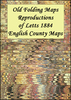
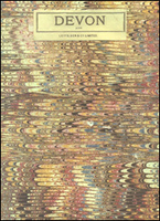
Devon 1884 Letts County Map

Devon in a series of cloth-backed reproductions from the Old Folding Maps of county maps published in late 19th century by Letts, Son & Co, with colouring and symbols providing a wealth of information, including towns where County Courts and Quarter Sessions are held, municipal boroughs, parliamentary county and borough boundaries with the number of returnable Members, etc. North and south division of the county are in different colours, and railway lines are prominently highlighted. Also provided is a list of Devon`s 55 Hundreds.Letts county maps present each county with colouring indicating its parliamentary divisions and show a large number of smaller towns and villages. Railways are prominently highlighted; on roads “dangerous hills” are marked. Other information includes
distance from London of main towns, market days, post towns, coast guard and life boat stations, etc. Each title also gives county statistics: population, area in acres, gross rental, inhabited houses, poor rate, and the number of paupers (!). Where appropriate, hachures are used to show the topography. The area outside the county boundary is not coloured but main towns plus road and rail connections are marked. Each map is backed onto cloth and presented folded in a colourful case covered with a unique design marbled paper.To see the list of all the titles in this series please click on the series link.
RIP - This product is no longer available on our network. It was last seen on 25.09.2019

This page now acts as a permanent archive for this product. Add more information using the comments box below to ensure it can still be found by future generations.

Use our search facility to see if it is available from an alternative contributor.
  • Availability: Out Of Stock
  • Supplier: Stanfords
  • SKU: 9786000012861
Availability: In Stock
£20.00

Product Description

Devon in a series of cloth-backed reproductions from the Old Folding Maps of county maps published in late 19th century by Letts, Son & Co, with colouring & symbols providing a wealth of information, including towns where County Courts & Quarter Sessions are held, municipal boroughs, parliamentary county & borough boundaries with the number of returnable Members, etc. North & south division of the county are in different colours, & railway lines are prominently highlighted. Also provided is a list of Devon`s 55 Hundreds. Letts county maps present each county with colouring indicating its parliamentary divisions & show a large number of smaller towns & villages. Railways are prominently highlighted; on roads “dangerous hills” are marked. Other information

Includes::
distance from London of main towns, market days, post towns, coast guard & life boat stations, etc. Each title also gives county statistics: population, area in acres, gross rental, inhabited houses, poor rate, & the number of paupers (!). Where appropriate, hachures are used to show the topography. The area outside the county boundary is not coloured but main towns plus road & rail connections are marked. Each map is backed onto cloth & presented folded in a colourful case covered with a unique design marbled paper. To see the list of all the titles in this series please click on the series link.

Reviews/Comments

Add New

Intelligent Comparison

Oooops!
We couldn't find anything!
Perhaps this product's unique.... Or perhaps we are still looking for comparisons!
Click to bump this page and we'll hurry up.

Price History

Vouchers

No voucher codes found.
Do you know a voucher code for this product or supplier? Add it to Insights for others to use.

Facebook

Jargon Buster

Paper - A thin sheet mainly used for writing. Available in a variety of colours. Made mainly from wood pulp.
Railways - A set of tracks that have been laid for the purpose of trains to travel up and down them
Large - something that takes up more space than normal.
Road - a manmade lane or a path that is used to speed up travel.
Design - A drawing or styles that shows the look and functionality of something before its made.

Supplier Information

Stanfords
Stanfords was established in 1853 and opened their iconic Covent Garden flagship store in 1901. They have become the top retailer of maps, travel books and accessories in the UK and arguably offer the largest selection of maps and travel books worldwide. Famous names such as Captain Robert Falcon Scott, Ranulph Fiennes and Michael Palin have purchased from Stanfords. They now have a shop in Bristol and both stores together with other venues operate a calendar of events including talks, book signings and exhibitions. As a specialist map retailer, the map selection is comprehensive and includes road maps, street maps and walking maps from worldwide destinations, as well as a selection of world atlases and wall maps. Books include travel guides and travel literature. Stanfords also stock globes, from miniatures made of blue marble to magnificent floor-standing globes. The website features a selection of interesting articles on travel topics.
Page Updated: 2023-11-12 20:15:36

Community Generated Product Tags

Oh No! The productWIKI community hasn't generated any tags for this product yet!
Menu