More From Contributor

£5.95
Devon & Cornwall on an indexed road map at 1:200, 000 (1” to 3 miles) from A-Z. Coverage along the north coast extends to Weston-super-Mare, & on the south coast to Lyme Regis & Bridport in Dorset. The index is next to the map. Current edition was published in 2016. Mapping in this regional series from A-Z has clear presentation of the road network, topographic information, places of interest, etc. Publishers’ cartography used in their 5 miles to 1” series is enlarged here to make local roads more prominent & provides all the standard motoring information: services, primary route destinations, toll barriers, gradients, locations of petrol stations & speed cameras, etc. Railway lines are shown with stations. Topography is indicated by colouring & relief shading for areas above 400 feet (122 metres), with additional colouring for woodlands. A wide range of symbols highlight various places of interest. Each title has British National Grid lines & is indexed. Selected regions are also covered by A5, paperback road atlases with the same cartography slightly enlarged, so with place names in larger print. The atlases include town centre street plans of main cities – for details please see individual descriptions. To see the list of titles in this series please click on the series link. ...
Archived Product
£9.95
Regional wall map of at 1:200, 000 (3.2 miles to 1inch) from A to Z, covering: Weston-super-Mare, Bridgwater, Bridport, Lyme Regis, Exmouth, Exeter, Torquay, Salcombe, Plymouth, Penzance, Land`s End, Newquay & Minehead.. Clear presentation of the road network shows motorways, A & B roads, some minor & local roads, with gradients of 1:5 & steeper indicated. Service stations, railway lines & stops, ferry terminals, & airports are clearly marked. Tourist information such as points of interest & local facilities are prominently highlighted with a variety of symbols. Topography is shown by altitude tints, if in rather broad bands, with spot heights (in feet) & additional colouring for woodland areas; the National Grid is overprinted on the cartography. National & unitary authority boundaries are indicated. There is an index for cities, town, & villages at the edge of the map. ...
Archived Product
£6.99
Regional wall map of at 1:200, 000 (3.2 miles to 1inch) from A to Z, covering: Weston-super-Mare, Bridgwater, Bridport, Lyme Regis, Exmouth, Exeter, Torquay, Salcombe, Plymouth, Penzance, Land`s End, Newquay & Minehead.. Clear presentation of the road network shows motorways, A & B roads, some minor & local roads, with gradients of 1:5 & steeper indicated. Service stations, railway lines & stops, ferry terminals, & airports are clearly marked. Tourist information such as points of interest & local facilities are prominently highlighted with a variety of symbols. Topography is shown by altitude tints, if in rather broad bands, with spot heights (in feet) & additional colouring for woodland areas; the National Grid is overprinted on the cartography. National & unitary authority boundaries are indicated. There is an index for cities, town, & villages at the edge of the map. ...
Archived Product
£9.99
This title
Includes:: expert advice, tracking down the best sights & experiences; suggested itineraries & highlights
...
Archived Product
£12.99
The Time Out Guide to Devon & Cornwall explores a range of things to do & see in the south-west & incorporates cultural events, local attractions, recommended pubs & restaurants, outdoor activities, local villages & towns & is suitable for residents, regular visitors or those new to the region. One of the few guides dedicated to Devon & Cornwall, the guide is organised locally by destination, allowing a comprehensive amount of detail on each local area. Time Out guides are strongly focussed on local entertainment & nightlife, in addition to principal sights & attractions, with expert local writers providing an encyclopaedic knowledge of the area. This unique quality has ensured that the guides have won a reputation for their accuracy & reliability. Each section is organised similarly, allowing readers to access the information they need easily. An overview of the area, including local towns, village & countryside of note is provided, with further sections dedicated to where to stay, eat & drink, places to visit & things to do. Thematic indexes for each county are also provided. ...
Archived Product
£5.95
Devon, Cornwall & West Somerset road atlas from Geographers’ A-Z Map Company covering the region at 1:158, 400 (1” to 2.5 miles), plus street plans & tourist information for 25 local towns. Numerous places of interest are prominently highlighted on the map & the plans, plus listed in an extensive index. Coverage along the northern coast extends to Weston-super-Mare, & on the southern coast to Lyme Regis & Bridport. Road network is shown with Primary Route Destinations prominently marked, services on motorways & major roads, locations of safety cameras with speed limits, tolls, steep gradients, etc. Topography is indicated by colouring for national parks, areas of natural beauty & woodlands. A very wide range of symbols indicates various attractions, places of interest & facilities, which are also listed in the index of towns & villages. 25 street plans, each accompanied by a brief description & a list of attractions, cover Barnstaple, Bodmin, Brixham, Bude, Dartmouth, Exeter, Falmouth, Fowey, Ilfracombe, Lauceston, Liskeard, Lynton – Lynmouth, Minehead, Newquay, Newton Abbot, Padstow, Paignton, Penzance, Plymouth, St. Ives, Taunton, Torquay & Truro. Current 8th edition of this title was published in 2014. To see the list of titles on A-Z’s Visitor’ series please click on the series link. ...
Archived Product
£7.95
Light booklet which won't add too much weight to your panier. For each of the twenty circular routes, a full description of the itinerary is given as well as practicalities such as the best map, how to get to the starting point using public transport & some photos & information about sights along the way. It

Includes::
rides near Tavistock, Bideford, Okehampton, Tiverton, Totnes & Sidmouth.

...
Archived Product
£7.95
Pub Strolls in Devon features thirty walks, of between 1.75 & 4 miles, in a slim full colour volume, combining some of the most beautiful scenery in the county with the opportunity to enjoy a meal & a drink at a recommended, good local pub. The book contains information about how to get to the start, where to park & places of interest to visit nearby, with photographs & stroll-route overview maps with numbers corresponding to the text description. Highlights include the busy historic harbour of Plymouth, the wild moorland of Exmoor & Dartmoor, the dramatic cliffs at Lee, the birdlife at Fremington, Exeter ...
Archived Product
£20.00
Devon in a series of cloth-backed reproductions from the Old Folding Maps of county maps published in late 19th century by Letts, Son & Co, with colouring & symbols providing a wealth of information, including towns where County Courts & Quarter Sessions are held, municipal boroughs, parliamentary county & borough boundaries with the number of returnable Members, etc. North & south division of the county are in different colours, & railway lines are prominently highlighted. Also provided is a list of Devon`s 55 Hundreds. Letts county maps present each county with colouring indicating its parliamentary divisions & show a large number of smaller towns & villages. Railways are prominently highlighted; on roads “dangerous hills” are marked. Other information

Includes::
distance from London of main towns, market days, post towns, coast guard & life boat stations, etc. Each title also gives county statistics: population, area in acres, gross rental, inhabited houses, poor rate, & the number of paupers (!). Where appropriate, hachures are used to show the topography. The area outside the county boundary is not coloured but main towns plus road & rail connections are marked. Each map is backed onto cloth & presented folded in a colourful case covered with a unique design marbled paper. To see the list of all the titles in this series please click on the series link.

...
Archived Product

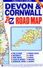
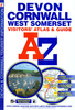
Devon & Somerset West OS Tour Map 5

Devon and western Somerset presented at 1:130, 000 on an indexed Ordnance Survey Tour Map with extensive tourist information including highlighting for national and regional cycle routes. Town navigation maps show main traffic arteries, tourist facilities and sights in Exeter, Plymouth, Bideford, Barnstaple, Brixham, Ilfracombe, Minehead, Newton Abbot, Sidmouth, Taunton, Tiverton, Torquay with Paignton, and Totnes. The map includes lists of selected places of interest, market days and farmers markets, plus brief notes on the Jurassic Coast World Heritage site. Current edition of this title was published in February 2016.To see the list of titles in this series please click on the series list – Ordnance Survey’s Tour maps have extra clear, uncluttered cartography.
Topography is shown by altitude colouring and relief shading, plus names of local hill or mountain ranges and heights of important peaks. Additional colouring indicates woodlands; boundaries of National Parks or designated Areas of Outstanding Natural Beauty are also marked. Road information very clearly distinguishes between different types of roads, from motorways to small local roads, with distances on main routes. Scenic routes are highlighted; motorway services, tolls, gradients on steep roads and level crossings are marked and towns used in motorway signs as Primary Route Destinations are indicated. Railway lines are shown with stations and, where appropriate, ferry routes are marked.Roads which are part of the national or regional cycle network are highlighted and shown with
route numbers; the maps also show the National Trail long-distance hiking paths. An extensive range of symbols indicate various places of interest, including campsites/caravan parks and youth hostels/bunkhouses, historic buildings, sport and recreational facilities, country pubs, etc. The maps have lines of the British National Grid. The place names index is supplemented by a list of selected places of interest plus, in most titles, of market days and/or farmers markets.The maps also include city navigation maps, highlighting main traffic arteries, car parks, principal sights and facilities, etc. For more information please see descriptions and coverage images of individual maps.
RIP - This product is no longer available on our network. It was last seen on 25.09.2019

This page now acts as a permanent archive for this product. Add more information using the comments box below to ensure it can still be found by future generations.

Use our search facility to see if it is available from an alternative contributor.
  • Availability: Out Of Stock
  • Supplier: Stanfords
  • SKU: 9780319263181
Availability: In Stock
£4.99

Product Description

Devon & western Somerset presented at 1:130, 000 on an indexed Ordnance Survey Tour Map with extensive tourist information including highlighting for national & regional cycle routes. Town navigation maps show main traffic arteries, tourist facilities & sights in Exeter, Plymouth, Bideford, Barnstaple, Brixham, Ilfracombe, Minehead, Newton Abbot, Sidmouth, Taunton, Tiverton, Torquay with Paignton, & Totnes. The map

Includes::
lists of selected places of interest, market days & farmers markets, plus brief notes on the Jurassic Coast World Heritage site. Current edition of this title was published in February 2016. To see the list of titles in this series please click on the series list – Ordnance Survey’s Tour maps have extra clear, uncluttered cartography. Topography is shown by altitude colouring & relief shading, plus names of local hill or mountain ranges & heights of important peaks. Additional colouring indicates woodlands; boundaries of National Parks or designated Areas of Outstanding Natural Beauty are also marked. Road information very clearly distinguishes between different types of roads, from motorways to small local roads, with distances on main routes. Scenic routes are highlighted; motorway services, tolls, gradients on steep roads & level crossings are marked & towns used in motorway signs as Primary Route Destinations are indicated. Railway lines are shown with stations &, where appropriate, ferry routes are marked. Roads which are part of the national or regional cycle network are highlighted & shown with route numbers; the maps also show the National Trail long-distance hiking paths. An extensive range of symbols indicate various places of interest, including campsites/caravan parks & youth hostels/bunkhouses, historic buildings, sport & recreational facilities, country pubs, etc. The maps have lines of the British National Grid. The place names index is supplemented by a list of selected places of interest plus, in most titles, of market days and/or farmers markets. The maps also include city navigation maps, highlighting main traffic arteries, car parks, principal sights & facilities, etc. For more information please see descriptions & coverage images of individual maps.

Reviews/Comments

Add New

Intelligent Comparison

Oooops!
We couldn't find anything!
Perhaps this product's unique.... Or perhaps we are still looking for comparisons!
Click to bump this page and we'll hurry up.

Price History

Vouchers

No voucher codes found.
Do you know a voucher code for this product or supplier? Add it to Insights for others to use.

Facebook

Jargon Buster

Hiking - An outdoor activity envolving walking in nature
Plymouth - A city on the coast of Devon
World - A physical grouping, commonly used to describe earth and everything associated with ti
Car - A machine used for transport which runs on roads
Natural - not manmade
Network - A link and communication between things. Often computers or people.
Small - something that takes up less space than normal.
Road - a manmade lane or a path that is used to speed up travel.
Altitude - Something that can be quite high in relation to sea or ground level.
Regional - An adjective to describe a set geographic area.
Primary - the beginning of something, of chief importance.
Individual - A single separate item or person.

Supplier Information

Stanfords
Stanfords was established in 1853 and opened their iconic Covent Garden flagship store in 1901. They have become the top retailer of maps, travel books and accessories in the UK and arguably offer the largest selection of maps and travel books worldwide. Famous names such as Captain Robert Falcon Scott, Ranulph Fiennes and Michael Palin have purchased from Stanfords. They now have a shop in Bristol and both stores together with other venues operate a calendar of events including talks, book signings and exhibitions. As a specialist map retailer, the map selection is comprehensive and includes road maps, street maps and walking maps from worldwide destinations, as well as a selection of world atlases and wall maps. Books include travel guides and travel literature. Stanfords also stock globes, from miniatures made of blue marble to magnificent floor-standing globes. The website features a selection of interesting articles on travel topics.
Page Updated: 2023-11-12 20:15:36

Community Generated Product Tags

Oh No! The productWIKI community hasn't generated any tags for this product yet!
Menu