More From Contributor

£20.00
Devon in a series of cloth-backed reproductions from the Old Folding Maps of county maps published in late 19th century by Letts, Son & Co, with colouring & symbols providing a wealth of information, including towns where County Courts & Quarter Sessions are held, municipal boroughs, parliamentary county & borough boundaries with the number of returnable Members, etc. North & south division of the county are in different colours, & railway lines are prominently highlighted. Also provided is a list of Devon`s 55 Hundreds. Letts county maps present each county with colouring indicating its parliamentary divisions & show a large number of smaller towns & villages. Railways are prominently highlighted; on roads “dangerous hills” are marked. Other information

Includes::
distance from London of main towns, market days, post towns, coast guard & life boat stations, etc. Each title also gives county statistics: population, area in acres, gross rental, inhabited houses, poor rate, & the number of paupers (!). Where appropriate, hachures are used to show the topography. The area outside the county boundary is not coloured but main towns plus road & rail connections are marked. Each map is backed onto cloth & presented folded in a colourful case covered with a unique design marbled paper. To see the list of all the titles in this series please click on the series link.

...
Archived Product
£6.99
Devon 30 Short walks is a handy pocket-sized box of 30 short walking routes in Devon. Contained within the box are 30 cards each with a short walking route, so walkers can easily take it with them on the walk for easy reference. All of the walks featured are between 1 & 4 miles long, allowing walkers to tackle them in a morning or afternoon. Key panels give details on distance, gradient, difficulty, surface & other practical advice. ...
Archived Product
£9.99
This compact & handy guide to short walks in Devon features walks between one & four miles long which can be covered in a morning or afternoon. There is an introduction for each walk giving background on the area, its history, wildlife & other points of interest; plus key information panels providing a summary of distance, time, gradient & ascent, level of difficulty, type of surface & access, landscape, dog friendliness, refreshments, parking & public toilets. Each walk has a highly detailed map & clear, easy-to-follow route directions. ...
Archived Product
£8.95
Devon Street Atlas from the Geographers` A-Z Map Company in a spiral-bound format slightly smaller than A4 & covering selected areas of the county including its holiday resorts at 1:16, 896 (3.75” to 1 mile). More detailed mapping at 1:8, 448 (7.5” to 1 mile) shows town centres of Exeter, Dartmouth & Plymouth. Current edition of this title was published in 2012. To see other titles in this series of A-Z county street atlases please click on the series link. A-Z also publish street atlases in a smaller A5 paperback format covering towns & cities with their surrounding areas
- for a list of titles in that series please search for SI00000932. Most A-Z county street atlases are in a spiral-bound format just smaller than A4 size, Most titles offer coverage of only the built-up areas, with selected titles covering the whole county
- as indicated in the individual descriptions & our area coverage images. Motorways plus A & B roads are highlighted by colouring & show route numbers. One way or restricted access streets, Park & Ride facilities & selected car parks are marked, as are locations of speed cameras. Also shown are selected cycleway routes. Where appropriate, A & B roads are annotated with selected house numbers for easier identification of addresses. Railway lines are shown with stations & level crossings. Colouring indicates different types of buildings: educational, hospitals & healthcare, industrial, leisure & recreational, shopping centres & markets, public buildings, & places of interest. Symbols mark locations of facilities usually indicated on street mapping: post offices, emergency services, public toilets, etc. Also marked are postcode & local authority boundaries. Each page has the lines & coordinates of the British National Grid. All the titles have a comprehensive index including, unless specified to the contrary in the description, separate entries for places of interest such as cultural & sport or recreational facilities, historical sites, nature reserves & gardens. Many titles include a separate list of hospitals & hospices in the area covered by the atlas.

...
Archived Product
£7.99
Devon & Cornwall in the Eyewitness Top 10 series from Dorling Kindersley is a condensed format guide book featuring dozens of illustrated, top ten lists for the traveller regardless of their disposable budget. To save you time & money a Top 10 Things to Avoid is also included. Top 10 lists are given for things to see & do across Devon, Cornwall & the Scilly Isles, as well as the top ten features of particular locations or events. Practicalities are not forgotten as Top 10s are also provided for topics such as planning your trip, getting around & shopping. Accommodation lists provide the ten most recommended places to stay for a range of budgets, whilst restaurant top tens feature as the guide works its way through the location in question. Simple, small street plans illustrate the location of the top ten recommends within their neighbourhoods & basic, fold out maps form the inside covers. An additional pull out feature of the guide suggests ideas on how to spend your day. ...
Archived Product
£8.99
An unbeatable, pocket-sized guide to Cornwall & Devon, packed with insider tips & ideas, colour maps, top 10 lists, & a laminated pull-out map
- all designed to help you see the very best of Cornwall & Devon. Admire Exeter`s historic cathedral, traverse Dartmoor`s expansive wilderness on foot, enjoy stunning beaches on the Isles of Scilly, discover a thriving art scene in St Ives or marvel at the Eden Project`s spectacular giant greenhouses. From Top 10 beaches to the Top 10 train rides
- discover the best of Cornwall & Devon with this easy-to-use travel guide. Inside Top 10 Cornwall & Devon:- Seven easy-to-follow itineraries perfect for a day trip, a weekend or a week- Top 10 lists showcase Cornwall & Devon`s best attractions, covering Lanhydrock, Porthcurno & the Minack, Penzance, Padstow & many more- Free laminated pull-out map of Cornwall & Devon, plus five colour neighbourhood maps- In-depth neighbourhood guides explore Cornwall & Devon`s most interesting areas, with the best places for shopping, going out & sightseeing
- Colour-coded chapters divided by area make it easy to find information quickly & plan your day
- Essential travel tips including our expert choices of where to stay, eat, shop & sightsee, plus useful transport, visa & health information- Colour maps help you navigate with ease- Covers North & South Devon, North & South Cornwall, the Isles of Scilly & more Staying for longer as part of a bigger trip around Great Britain? Try our DK Eyewitness Travel Guide Great Britain. About DK Eyewitness Travel: DK`s Top 10 guides take the work out of planning a short trip, with easy-to-read maps, tips & tours to inform & enrich your weekend trip or cultural break. DK is the world`s leading illustrated reference publisher, producing beautifully designed books for adults & children in over 120 countries.


...
Archived Product
£7.99
DK Eyewitness Top 10 Travel Guide: Devon & Cornwall will lead you straight to the very best on offer. Whether you`re looking for the things not to miss at the Top 10 sights, or want to find the best beaches & bays; this guide is the perfect pocket-sized companion. You can rely on dozens of Top 10 lists
- from the Top 10 museums to the Top 10 best cream teas
- there`s even a list of the Top 10 things to avoid. The guide is divided by area with restaurant reviews for each, as well as recommendations for hotels, bars & places to shop. You`ll find the insider knowledge every visitor needs & explore every corner effortlessly with DK Eyewitness Top 10 Travel Guide: Devon & Cornwall & its FREE pull-out map. DK Eyewitness Top 10 Travel Guide: Devon & Cornwall
- showing you what others only tell you.


...
Archived Product
£7.99
Devon & Cornwall in the Eyewitness Top 10 series from Dorling Kindersley is a condensed format guide book featuring dozens of illustrated, top ten lists for the traveller regardless of their disposable budget. To save you time & money a Top 10 Things to Avoid is also included. Top 10 lists are given for things to see & do across Devon, Cornwall & the Scilly Isles, as well as the top ten features of particular locations or events. Practicalities are not forgotten as Top 10s are also provided for topics such as planning your trip, getting around & shopping. Accommodation lists provide the ten most recommended places to stay for a range of budgets, whilst restaurant top tens feature as the guide works its way through the location in question. Simple, small street plans illustrate the location of the top ten recommends within their neighbourhoods & basic, fold out maps form the inside covers. An additional pull out feature of the guide suggests ideas on how to spend your day. ...
Archived Product
£5.99
Whether you are seeking indulgent cream teas, brilliant beaches, Cornish myths & legends or the wilderness of moorl&, this Footprint Focus guide will prove an invaluable companion to any trip to Devon & Cornwall. The most westerly point of England has an independent spirit that will enchant any visitor, & Footprint`s up-to-date listings of the best of restaurants, accommodation, activities & off-the-beaten-track places to visit will ensure that you make the most of your trip. Essentials section with useful advice on getting to & around Devon, Cornwall & the Isles of Scilly. Comprehensive, up-to-date listings of where to eat, sleep & play.

Includes::
information on tour operators & activities, from surfing to exploring castles. Detailed maps for the region. Slim enough to fit in your pocket. With detailed information on all the attractions, plus many lesser-known sights, Footprint Focus Devon & Cornwall (
Includes: Isles of Scilly) provides concise & comprehensive coverage of one of Britain`s best-loved regions. The content of the Footprint Focus Devon & Cornwall (
Includes: Isles of Scilly) guide has been extracted from Footprint Engl&.


...
Archived Product

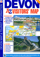
Devon A-Z Visitors` Map

Devon Visitors’ Map from Geographers’ A-Z Map Company covering the county at 1:158, 400 (1” to 2.5 miles), plus seven street plans. Numerous places of interest are prominently highlighted on the map and the plans, plus listed in an extensive index. Road network is shown with Primary Route Destinations prominently marked, services on motorways and major roads, locations of safety cameras with speed limits, etc. Topography is indicated by colouring for national parks, areas of natural beauty and woodlands. A very wide range of symbols indicates various attractions, places of interest and facilities, which are also listed in the index of towns and villages, placed next to the map. Surrounding the map are street plans of Barnstable, Brixham, Dartmouth, Exeter, Plymouth,
Paignton and Torquay. Current 8th edition of this title was published in 2015. To see the list of titles on A-Z’s Visitor’ series please click on the series link.
RIP - This product is no longer available on our network. It was last seen on 25.09.2019

This page now acts as a permanent archive for this product. Add more information using the comments box below to ensure it can still be found by future generations.

Use our search facility to see if it is available from an alternative contributor.
  • Availability: Out Of Stock
  • Supplier: Stanfords
  • SKU: 9781782570233
Availability: In Stock
£5.95

Product Description

Devon Visitors’ Map from Geographers’ A-Z Map Company covering the county at 1:158, 400 (1” to 2.5 miles), plus seven street plans. Numerous places of interest are prominently highlighted on the map & the plans, plus listed in an extensive index. Road network is shown with Primary Route Destinations prominently marked, services on motorways & major roads, locations of safety cameras with speed limits, etc. Topography is indicated by colouring for national parks, areas of natural beauty & woodlands. A very wide range of symbols indicates various attractions, places of interest & facilities, which are also listed in the index of towns & villages, placed next to the map. Surrounding the map are street plans of Barnstable, Brixham, Dartmouth, Exeter, Plymouth, Paignton & Torquay. Current 8th edition of this title was published in 2015. To see the list of titles on A-Z’s Visitor’ series please click on the series link.

Reviews/Comments

Add New

Intelligent Comparison

Oooops!
We couldn't find anything!
Perhaps this product's unique.... Or perhaps we are still looking for comparisons!
Click to bump this page and we'll hurry up.

Price History

Vouchers

No voucher codes found.
Do you know a voucher code for this product or supplier? Add it to Insights for others to use.

Facebook

Jargon Buster

Plymouth - A city on the coast of Devon
speed - A measurement of how fast an object travels between two points
Safety - prevents damage being caused.
Natural - not manmade
Network - A link and communication between things. Often computers or people.
Road - a manmade lane or a path that is used to speed up travel.
Wide - Something with a large width.
Primary - the beginning of something, of chief importance.

Supplier Information

Stanfords
Stanfords was established in 1853 and opened their iconic Covent Garden flagship store in 1901. They have become the top retailer of maps, travel books and accessories in the UK and arguably offer the largest selection of maps and travel books worldwide. Famous names such as Captain Robert Falcon Scott, Ranulph Fiennes and Michael Palin have purchased from Stanfords. They now have a shop in Bristol and both stores together with other venues operate a calendar of events including talks, book signings and exhibitions. As a specialist map retailer, the map selection is comprehensive and includes road maps, street maps and walking maps from worldwide destinations, as well as a selection of world atlases and wall maps. Books include travel guides and travel literature. Stanfords also stock globes, from miniatures made of blue marble to magnificent floor-standing globes. The website features a selection of interesting articles on travel topics.
Page Updated: 2023-11-12 20:15:36

Community Generated Product Tags

Oh No! The productWIKI community hasn't generated any tags for this product yet!
Menu